
Lake Ontario’s New York shoreline
By Communications and Publishing
2017 (approx.)

Detailed Description
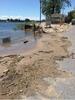
As floodwaters recede, USGS scientists document high water marks, which include debris carried by flood water. The USGS Flood Inundation Mapper incorporates data about past flooding on Lake Ontario’s New York shoreline, including high water marks. Photo by Jared Marion, USGS.
Sources/Usage
Public Domain.