
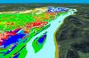
Land cover data draped over aerial photography and lidar, Upper MS riv

Detailed Description
Land cover data draped over lidar and aerial photography for the Upper Mississippi River System floodplain, between Minneapolis, Minnesota, and Cairo, Illinois.