
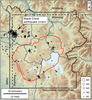
Map of earthquakes in the Yellowstone area (2017)

Detailed Description
Map of earthquakes in the Yellowstone area in 2017 that were individually located using traditional methods by University of Utah Seismograph Stations. The Maple Creek earthquake swarm, northwest of the caldera (red outline), is the second-longest-lasting ever recorded in the region. Black line shows Park boundary, and white lines are roads. Dashed lines are state boundaries.
Sources/Usage
Public Domain.