
Map of the Grand Bay National Estuarine Research Reserve

Detailed Description
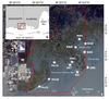
Figure 1: Map of the Grand Bay National Estuarine Research Reserve (red boundary line) with white stars depicting the location of shoreline erosion study sites (a). The inset map (b) shows the location of the study region on the border of Mississippi and Alabama, USA, in the northern Gulf of America. Sites names refer to: BHM = Bayou Heron Mouth; MBN, MBW, MBS = Middle Bay North, West, and South, respectively; GBE = Grand Batture East; BSI = Bird Island; SPAL = North Jose Bay; MET = Met Station Island; PACN, PACM, PACS = Point aux Chenes North, Middle, and South, respectively. Data sources: Shoreline from © OpenStreetMap contributors (https://www.openstreetmap.org/ accessed on 30 October 2018). Image basemap from © Maxar Technologies, 2020 (https://www.maxar.com/, accessed on 28 July 2021). All rights reserved. Courtesy of Journal of Remote Sensing.
Sources/Usage
This is an open access article distributed under the Creative Commons Attribution License which permits unrestricted use, distribution, and reproduction in any medium, provided the original work is properly cited.