
Map shows hazard zone for pyroclastic flows and surges around poten...
By Volcano Hazards Program
2012 (approx.)

Detailed Description
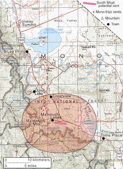
Map shows hazard zone for pyroclastic flows and surges around potential vents in the Mammoth Mountain area of the Long Valley Caldera.
Sources/Usage
Public Domain.
Related

Pyroclastic Flow and Surge Hazard Zones from Potential Vents in the Mammoth Mountain Area, Long Valley Caldera, California
This hazard zone is based on explosive eruptions from vents located along the chain in the past 10,000 years that are known to have ejected <1 square kilometers (0.25 square miles) of magma and generated pyroclastic flows or surges.
Pyroclastic Flow and Surge Hazard Zones from Potential Vents in Long Valley Caldera, California
Areas as far as 15 km (10 mi) from an explosive eruption could be swept by hot, fast-moving pyroclastic flows and surges.
Related
Pyroclastic Flow and Surge Hazard Zones from Potential Vents in the Mammoth Mountain Area, Long Valley Caldera, California
This hazard zone is based on explosive eruptions from vents located along the chain in the past 10,000 years that are known to have ejected <1 square kilometers (0.25 square miles) of magma and generated pyroclastic flows or surges.
Pyroclastic Flow and Surge Hazard Zones from Potential Vents in Long Valley Caldera, California
Areas as far as 15 km (10 mi) from an explosive eruption could be swept by hot, fast-moving pyroclastic flows and surges.