
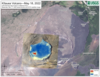
May 18, 2022—Kīlauea summit UAS thermal maps
By Kīlauea

Detailed Description
Unoccupied aircraft systems (UAS) flights on May 18, 2022, allowed for aerial visual and thermal imagery to be collected of Halema‘uma‘u crater at the summit of Kīlauea. The active lake surface is limited to the western portion of the crater. The scale of the thermal map ranges from blue to red, with blue colors indicative of cooler temperatures and red colors indicative of warmer temperatures. USGS has special use permits from the National Park Service to conduct official UAS missions as part of HVO’s mission to monitor active volcanoes in Hawaii, assess their hazards, issue warnings, and advance scientific understanding to reduce impacts of volcanic eruptions.
Sources/Usage
Public Domain.