
Research vessel Alaskan Gyre

Detailed Description
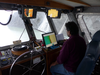
Within a stone’s throw of the steep shoreline, the USGS research vessel Alaskan Gyre collects multibeam bathymetry data above the Taan Fiord landslide. Note the upper right chart plotter screen shows the vessel on land in the center of the screen. This area had not had a proper bathymetric survey since deglaciation about 30 years ago.
Sources/Usage
Public Domain.