
Satellite image shows June 27th lava flow

Detailed Description
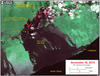
This satellite image was captured on Monday, November 30, by the Advanced Land Imager instrument onboard NASA's Earth Observing 1 satellite. The image is provided courtesy of NASA's Jet Propulsion Laboratory. Although this is a false-color image, the color map has been chosen to mimic what the human eye would expect to see. Bright red pixels depict areas of very high temperatures and show active lava. White areas are clouds.
The image shows that scattered breakouts continue to be active northeast of Pu‘u ‘Ō‘ō in two main areas. First, small scattered breakouts are active as far as 5.8 km (3.6 miles) from the vent on Pu‘u ‘Ō‘ō, continuing the activity we have seen over the past several months. Second, the breakout that began on November 25 continues to be active, but this breakout is still relatively minor and extends no farther than 2 km (1.2 miles) from Pu‘u ‘Ō‘ō.