
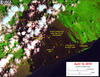
Satellite image shows location of breakouts on flow field

Detailed Description
This satellite image was captured on Thursday, April 12, by the Landsat 8 satellite. Although this is a false-color image, the color map has been chosen to mimic what the human eye would expect to see. Bright red pixels depict areas of high temperatures and show active lava. White areas are clouds.
The image shows that breakouts continue in several areas on the flow field. The largest breakout is in the upper flow field, about 1 km (0.6 miles) east of Pu‘u ‘Ō‘ō. The closest breakouts to the coast include a few small areas that are active near the top of the pali.