
Selenium in Ecosystems: San Francisco Bay Satellite Image

Detailed Description
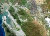
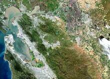
A satellite view of the San Francisco Bay-Delta Estuary showing details of the hydrologic system that is shaped by the Sacramento and San Joaquin Rivers and extends to the Pacific Ocean.
Sources/Usage
Public Domain.
Related

Linking Selenium Sources to Ecosystems: Refining
The San Francisco Bay-Delta receives selenium (Se) internally from oil refineries and externally through riverine agricultural discharges. Predator species considered at risk from Se consume the estuary’s dominant bivalve, C. amurensis, an efficient bioaccumulator of Se. Modeling predicts site-specific ecological risk and derives a range of protective Se concentrations for use by decision-makers.
Related
Linking Selenium Sources to Ecosystems: Refining
The San Francisco Bay-Delta receives selenium (Se) internally from oil refineries and externally through riverine agricultural discharges. Predator species considered at risk from Se consume the estuary’s dominant bivalve, C. amurensis, an efficient bioaccumulator of Se. Modeling predicts site-specific ecological risk and derives a range of protective Se concentrations for use by decision-makers.