
September 2009 Flooding Sweetwater Creek at Interstate 20, Lithia Springs, Georgia
By South Atlantic Water Science Center (SAWSC)
September 2009 (approx.)
Detailed Description
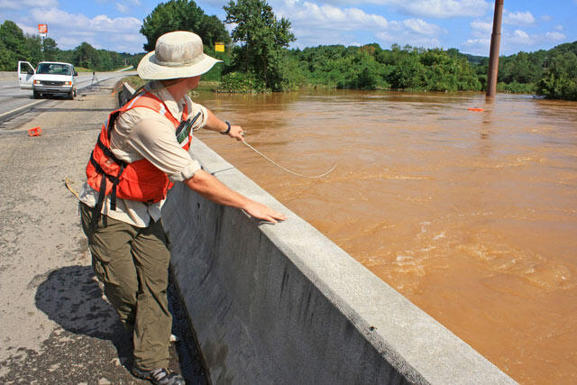
This is the Interstate 20 bridge over Sweetwater Creek. The USGS hydrographer is hand-pulling an Acoustic Doppler Current Profiler across the channel. The instrument, on the small orange catamaran in the picture, determines the depth of the channel and the discharge of the water and transmits data to a laptop in the van in the far left of the photo. The channel was up to 30 feet deep in places and discharge was around 25,000 cubic feet per second.
Sources/Usage
Public Domain.
Related

Epic September 2009 Flooding - Georgia
Many days of continuous heavy rain in mid-September 2009 resulted in flooding in many parts of Georgia, especially in north Georgia and the Atlanta region. The rains produced streamflows of record proportions. rivers and streams had magnitudes so great that the odds of it happening were less than 0.2 percent in any given year. In other words, there was less than a 1 in 500 chance that parts of...
Related
Epic September 2009 Flooding - Georgia
Many days of continuous heavy rain in mid-September 2009 resulted in flooding in many parts of Georgia, especially in north Georgia and the Atlanta region. The rains produced streamflows of record proportions. rivers and streams had magnitudes so great that the odds of it happening were less than 0.2 percent in any given year. In other words, there was less than a 1 in 500 chance that parts of...