
Synthetic Aperture Radar (SAR) satellite images of Pacific walruses
By Alaska Science Center
September 2022 (approx.)

Detailed Description
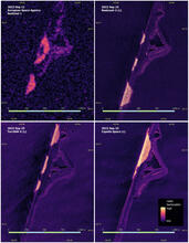
Figure comparing Synthetic Aperture Radar (SAR) satellite images of Pacific walruses on a terrestrial haulout near Point Lay, Alaska, as collected by four different SAR instruments possessing different spatial resolution capabilities (Sentinel-1, Radarsat-2, TerraSAR-X, and Capella Space).
USGS has found that SAR imagery can detect walruses when they rest on shore in large numbers and is pursuing studies to understand how satellite imagery can support improved management of the Pacific walrus. Read USGS study at: https://doi.org/10.3390/rs13214266
Sources/Usage
Public Domain.
Anthony Fischbach, USGS Alaska Science Center