
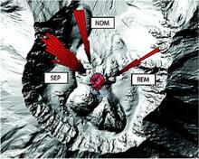
Tilt directions illustrated by a rose plot at Mount St. Helens duri...
By Volcano Hazards Program
2010 (approx.)

Detailed Description
Rose plots of hand-picked tilt azimuths. Azimuths converge near the south end of the 1980s lava dome. Red oval shows approximate location of 1980 conduit, estimated from the location of a welt which grew on the crater floor following the 1980 eruption and was later buried by a series of lava domes. Black cross shows the location of the center of the radial coordinate system. Background shaded relief map is from February 2006.
Sources/Usage
Public Domain.
Anderson et. al., 2010