
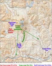
Topographic map, Mount St. Helens, C.E. 1919 annotated with locatio...
By Volcano Hazards Program
1905 (approx.)

Detailed Description
Due to the cataclysmic eruption of May 18, 1980, many of the locations annotated on this map are now either covered or no longer visible.
Sources/Usage
Public Domain.
Adapted from