
USGS Baton Rouge Streamgage

Detailed Description
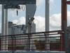
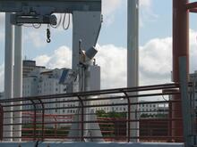
The USGS streamgage at the Baton Rouge City Docks. Streamgages like this one are located throughout Louisiana and the entire country along rivers and streams. They collect important data like water levels, streamflow, water quality, and other measurements. This gage collects water level information every 15 minutes and transmits data every hour via the GOES Weather satellite to the USGS website, which displays the realtime data for 120 days. This information ensures the US Army Corps of Engineers has accurate, up-to-date information with which to base its river management decisions.
Sources/Usage
Public Domain.