
USGS San Diego Hydrogeology project study area
By California Water Science Center
March 2022 (approx.)

Detailed Description
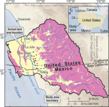
Map illustrating the USGS San Diego Hydrogeology project study area, which extends offshore of San Diego. Sedimentary deposits are shown in yellow; hard rock is shown in pink; streams and water bodies are shown in blue; USGS monitoring-well sites are indicated by red dots. (Click to enlarge.)
Sources/Usage
Public Domain.