
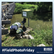
USGS scientists Dave Brower (left) and Taylor Naglieri (right) working on logging data that was being collected by Rob Lorens at # 01582500 Gunpower Falls at Glencoe MD, in northern Baltimore County, MD

Detailed Description
Hydrologic Technicians Dave Brower, and Taylor Naglieri are shown logging data that was being collected by Rob Lorens in the stream (not pictured). The photo was taken at # 01582500 Gunpower Falls at Glencoe MD, in northern Baltimore County, MD
The site on the west bank is just across the bridge from the Torrey C. Brown rails-to-trail multi-use path ... the same Railroad that Lincoln took to give the Gettysburg Address in 1863!
The data from this gage represents approximately 160square miles of watershed before the Gunpowder River flows into the Loch Raven Reservoir, which primarily supplies drinking water to Baltimore City and parts of Baltimore County.
Access data for this gage:
USGS Current Conditions for USGS 01582500 GUNPOWDER FALLS AT GLENCOE, MD
Sources/Usage
Public Domain.