
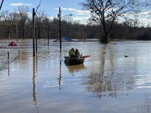
USGS water experts measure floodwaters at Green River in Munfordville, KY

Detailed Description
USGS water experts Logan VanWatermulen and Shawn LeMaster measure how high and fast floodwaters move at Green River in Munfordville, KY on February 17. This real-time data is used by emergency managers to help protect lives and property. The Green River streamgage has been collecting data since 1915 and is funded by the U.S. Army Corps of Engineers and USGS. The data are used by the National Oceanic and Atmospheric Agency and the National Weather Service for flood forecasting.
Sources/Usage
Public Domain.