
Geologic Mapping and Foundational Science
We deliver detailed mapping and foundational science about our Nation and world’s geology and geologic resources.
Delivering knowledge to be built upon.
Collecting data is often the most time, cost and labor-intensive part of answering scientific questions and producing new knowledge. Today, with accelerating computational power, the ability to use and analyze massive data sets has never been greater – but this power can only be harnessed if large, high-quality datasets exist.
With our long-standing mission and nation-wide network of scientists and partners, we are uniquely positioned to coordinate the collection, compilation and preservation of large, geologic data sets that span time and space, and that can be used to answer many kinds of scientific questions.
EXPLORE
FOUNDATIONAL GEOLOGIC MAPPING
COMPILING LARGE DATASETS
PRESERVING DATA FOR THE FUTURE
It all starts with a map.
High quality maps are essential to high quality decisions. One kind of foundational data we deliver are maps necessary to understand and visualize the Nation’s geology structure and energy and mineral resources.
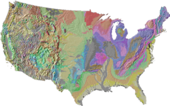
- Our National Cooperative Geologic Mapping Program is the primary source in the U.S. for geologic map production. Geologic maps show what rocks are present at and below the Earth’s surface. This information is essential for predicting potential energy and mineral resources, identifying natural hazards like earthquakes, understanding water resource availability, planning infrastructure projects, and a wide range of other purposes.
- Our Earth Mapping Resources Initiative (Earth MRI) collects a suite of data to map the surface and subsurface of the Nation, including geophysical, topographic, geologic, geochemical, hyperspectral and mine waste data. Earth MRI focuses on collecting data in areas with potential critical mineral resources.
- Our Mineral Resources Program and Energy Resources Program also deliver local, regional, or national-scale maps related to specific geologic resources.
Data across time and space.
Even with advances in computing, models used to answer critical questions are only as good as the quality of the data that are used to develop them. We are developing the kinds of large, quality databases needed for this age.
Our strong partnerships are key to our databases, which often include data collected or analyzed by USGS, as well as by a wide network of State, Tribal, industry, academic and other partners. At the nexus of this broad network, we are able to compile useful databases that span wide ranges of time and space.
Here are some examples:
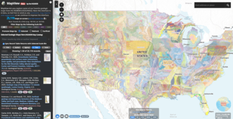
- Our National Geologic Map Database is the official archive of geologic maps of the Nation. This database is publicly available from a USGS web site and serves approximately 200,000 users per month.
- Our Mineral Resources Program provides national databases of known mineral deposits, mine and mine waste features, and geochemical and geochronological data.
- Our Energy Resources Program provides national databases of the locations of orphaned wells, the geochemistry of waters produced during petroleum and geothermal energy production, and coal resources.
- Our National Minerals Information Center has over 100 years of data on U.S. mineral production and trade that can be used to track past patterns and predict future ones.
Data preservation reduces duplicative efforts, saving time and money.
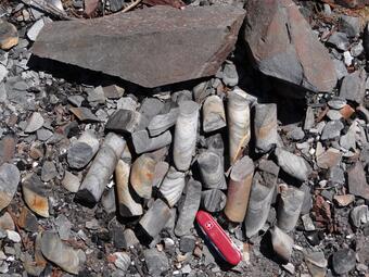
Our National Geological and Geophysical Data Preservation Program maintains both physical and digital collections of geologic data and promotes their use and access. Our ReSciColl digital catalogue of geologic samples, photographs, maps and other data contains over 5 million entries. Additionally, our other digital resource, the National Index of Borehold Information (NIBI), provides advanced search and access to a centralized index of subsurface resources. The Map Viewer application in NIBI allows for an interactive way to explore, filter and query NGGDPP borehole data on a map.
The Program also maintains a physical repository that contains tens of thousands of geologic samples including borehole cores donated by industry. These data are used regularly by industry and scientists, with visits to both the physical and digital space occurring nearly every day.
We deliver detailed mapping and foundational science about our Nation and world’s geology and geologic resources.
Delivering knowledge to be built upon.
Collecting data is often the most time, cost and labor-intensive part of answering scientific questions and producing new knowledge. Today, with accelerating computational power, the ability to use and analyze massive data sets has never been greater – but this power can only be harnessed if large, high-quality datasets exist.
With our long-standing mission and nation-wide network of scientists and partners, we are uniquely positioned to coordinate the collection, compilation and preservation of large, geologic data sets that span time and space, and that can be used to answer many kinds of scientific questions.
EXPLORE
FOUNDATIONAL GEOLOGIC MAPPING
COMPILING LARGE DATASETS
PRESERVING DATA FOR THE FUTURE
It all starts with a map.
High quality maps are essential to high quality decisions. One kind of foundational data we deliver are maps necessary to understand and visualize the Nation’s geology structure and energy and mineral resources.
- Our National Cooperative Geologic Mapping Program is the primary source in the U.S. for geologic map production. Geologic maps show what rocks are present at and below the Earth’s surface. This information is essential for predicting potential energy and mineral resources, identifying natural hazards like earthquakes, understanding water resource availability, planning infrastructure projects, and a wide range of other purposes.
- Our Earth Mapping Resources Initiative (Earth MRI) collects a suite of data to map the surface and subsurface of the Nation, including geophysical, topographic, geologic, geochemical, hyperspectral and mine waste data. Earth MRI focuses on collecting data in areas with potential critical mineral resources.
- Our Mineral Resources Program and Energy Resources Program also deliver local, regional, or national-scale maps related to specific geologic resources.
Data across time and space.
Even with advances in computing, models used to answer critical questions are only as good as the quality of the data that are used to develop them. We are developing the kinds of large, quality databases needed for this age.
Our strong partnerships are key to our databases, which often include data collected or analyzed by USGS, as well as by a wide network of State, Tribal, industry, academic and other partners. At the nexus of this broad network, we are able to compile useful databases that span wide ranges of time and space.
Here are some examples:
- Our National Geologic Map Database is the official archive of geologic maps of the Nation. This database is publicly available from a USGS web site and serves approximately 200,000 users per month.
- Our Mineral Resources Program provides national databases of known mineral deposits, mine and mine waste features, and geochemical and geochronological data.
- Our Energy Resources Program provides national databases of the locations of orphaned wells, the geochemistry of waters produced during petroleum and geothermal energy production, and coal resources.
- Our National Minerals Information Center has over 100 years of data on U.S. mineral production and trade that can be used to track past patterns and predict future ones.
Data preservation reduces duplicative efforts, saving time and money.
Our National Geological and Geophysical Data Preservation Program maintains both physical and digital collections of geologic data and promotes their use and access. Our ReSciColl digital catalogue of geologic samples, photographs, maps and other data contains over 5 million entries. Additionally, our other digital resource, the National Index of Borehold Information (NIBI), provides advanced search and access to a centralized index of subsurface resources. The Map Viewer application in NIBI allows for an interactive way to explore, filter and query NGGDPP borehole data on a map.
The Program also maintains a physical repository that contains tens of thousands of geologic samples including borehole cores donated by industry. These data are used regularly by industry and scientists, with visits to both the physical and digital space occurring nearly every day.