
Our science supports decisions at the mineral-energy nexus, helping decisionmakers plan for energy independence, security and resilience.
The Minerals-Energy Connection
America’s energy infrastructure is built by minerals, from the power plants that produce electricity, power lines that move it and batteries that store it. Today, energy needs are changing. New mineral-intensive infrastructure is needed to meet rising energy demands and to advance next-generation energy technologies, from smart grids to energy storage. At the same time, the rapid expansion of digital infrastructure, such as data centers, is intensifying the need for both mineral and energy resources.
Minerals to Build America’s Energy Future
The vitality of minerals to building America’s future energy systems is underscored by the USGS’ List of Critical Minerals, the Department of Energy (DOE)’s List of Critical Materials, and multiple of President Trump’s executive orders (EO 14154, EO 14156 and EO 14213).
How USGS is Helping
Building America’s energy future will require putting together many puzzle pieces – from what minerals we can source, to what energy resources we can develop, and how efficiently we can use mineral and energy resources.
The four research Programs within the USGS Geology, Energy and Minerals Mission Area deliver complimentary science that work together to help make sense of these puzzle pieces, and how they could fit together.
Explore Our Science in Action
Coal and Rare Earth Elements
Lithium, Petroleum and Geothermal
Critical Minerals and Geologic Hydrogen
Underground Energy Storage
Mining for coal… and rare earth elements?
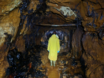
Is there more energy to be unlocked from coal? Waste from coal processing, precipitates from coal acid mine drainage, and fly ash, a very fine grain solid produced during the burning of coal, contain valuable rare earth elements (REEs), a subset of USGS identified critical minerals. REEs are a group of 17 chemically similar metallic elements that are increasingly required for a range of modern applications in defense and renewable energy technologies and in commercial products, primarily as magnets, batteries, and catalysts.
USGS-led research has identified coal and mineral components, such as aluminum and silicon, in fly ash with the highest REE concentrations. REEs bound in aluminosilicate glasses are currently difficult to recover, but we work with the Department of Energy to study the methods and limitations around effective REE extraction from coal waste.
REEs are necessary components in more than 200 products across a wide range of applications. Significant defense applications include electronic displays, guidance systems, lasers, and radar and sonar systems. And although magnets made of REE often represent only a small fraction of the total weight of the products they are in, without them, cell phone microphones and speakers would not be possible.
The Smackover: a new lithium boom in a petroleum producing region?
The Smackover Formation is a relic of an ancient sea that left an extensive, porous, and permeable limestone geologic unit under parts of Arkansas, Louisiana, Texas, Alabama, Mississippi, and Florida. The Formation has been a prolific oil producer for over 100 years, and a major economic driver in the region, spurring transformative booms in the 1920s and 1960s.
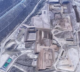
Today, USGS science is shedding light on a resource that could spur a new wave of economic activity in the region: lithium. Global demand has been rising rapidly for lithium, which is used to make batteries in everything from consumer electronics to cars. In addition to oil, the briny waters in the Smackover Formation contain lithium that could be brought to the surface and extracted through a series of chemical steps.
Building on decades of research in the Gulf Coast region, the USGS estimated between 5 and
19 million tons of lithium reserves are located beneath southwestern Arkansas alone. If commercially recoverable, this amount of lithium could meet global demand several times over. These estimates are contributing to a new wave of investment in the region by major petroleum and other energy companies who have begun feasibility studies and test sites for extracting lithium in the area.
Through this science, USGS is highlighting ways towards coproduction of a vital energy resource and a mineral key to energy technologies.
Building on decades of research in the Gulf Coast region, the USGS estimated between 5 and 19 million tons of lithium reserves are located beneath southwestern Arkansas alone. If commercially recoverable, this amount of lithium could meet global demand several times over. These estimates are contributing to a new wave of investment in the region by major petroleum and other energy companies who have begun feasibility studies and test sites for extracting lithium in the area.
Through this science, USGS is highlighting ways towards coproduction of a vital energy resource and a mineral key to energy technologies.
The Salton Sea: energy and minerals from the salt (and heat) of the Earth
The Salton Sea in the Imperial Valley of California could be a boon of energy and lithium. Below the man-made shallow lake, groundwater heated by the Earth holds the potential for one of the largest geothermal fields in the world. The salty brines that hold this geothermal potential also hold another valuable resource: lithium. This could be a prime location to coproduce geothermal energy and lithium at the same time by extracting both lithium and heat from the brines that are circulated towards the surface during geothermal energy production.
USGS mapping and science is helping to provide insights into how feasible these operations might be and where they would be ideally targeted. In 2020, for instance, in partnership with the Department of Energy, USGS collected high-resolution magnetic and radiometric data using specially equipped, low-flying aircraft that capture features below the Earth’s surface. These data are providing information not only about potential geothermal, lithium and other mineral resources, but also about potential hazards to future infrastructure like earthquakes.
In this region, USGS is equipping decision makers and local communities with the information they need to shape both their local and national energy and mineral future.
Mapping is essential for identifying the Nation’s energy and mineral resources.
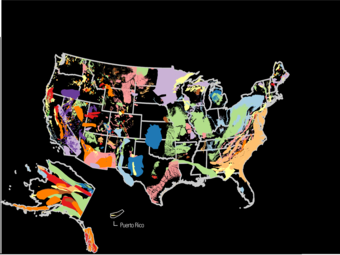
USGS is mapping both the surface and subsurface of the Earth, allowing scientists to “see” new areas of potential for resources. One example is mapping by the Earth Mapping Resources Initiative (Earth MRI) which focuses on collecting data in areas with potential for critical minerals. However, several of the areas covered by Earth MRI are also being mined for the information they might provide about another resource: geologic hydrogen.
Geologic hydrogen is a resource of emerging interest that could have enormous potential, but is still not well understood. Formed deep below the ground, typically near very old rocks under specific geologic conditions, geologic hydrogen is a gas that could be a continuous source of energy with a relatively low environmental impact.
Using low-flying flights that can measure the magnetic and radiometric qualities of rocks beneath the Earth’s surface, scientists in both the public and private sectors are gaining never before looks at regions of the U.S. that could host this resource, and in the future even develop it.
The Earth is able to store energy – just like a very large battery.
Rocks below the Earth’s surface have cracks, fissures and spaces that can be filled with gases like hydrogen, or fluids with thermal energy (i.e. that are hot or cold). When energy is needed, the gases or liquids can be extracted and used to generate electricity, or heat and cool buildings.
Still an emerging field of science and technology, underground energy storage has the potential to make energy grids more efficient, replacing some need for industrial scale batteries or even new energy production infrastructure. For instance, underground thermal energy storage used to directly heat and cool buildings could help meet demands for energy consumption. Gases used to produce energy like hydrogen or carbon dioxide could also be stored underground until needed. All of these purposes could help reduce the need for additional mineral-intensive energy infrastructure.
USGS is at the cutting edge of this emerging resource, studying the thermodynamics, capacity and implications of underground energy storage – fundamental information that is directly supporting a nascent energy industry. USGS is currently assessing how much space might be available below the Nation’s surface to store energy resources like natural gas or hydrogen.
Our science supports decisions at the mineral-energy nexus, helping decisionmakers plan for energy independence, security and resilience.
The Minerals-Energy Connection
America’s energy infrastructure is built by minerals, from the power plants that produce electricity, power lines that move it and batteries that store it. Today, energy needs are changing. New mineral-intensive infrastructure is needed to meet rising energy demands and to advance next-generation energy technologies, from smart grids to energy storage. At the same time, the rapid expansion of digital infrastructure, such as data centers, is intensifying the need for both mineral and energy resources.
Minerals to Build America’s Energy Future
The vitality of minerals to building America’s future energy systems is underscored by the USGS’ List of Critical Minerals, the Department of Energy (DOE)’s List of Critical Materials, and multiple of President Trump’s executive orders (EO 14154, EO 14156 and EO 14213).
How USGS is Helping
Building America’s energy future will require putting together many puzzle pieces – from what minerals we can source, to what energy resources we can develop, and how efficiently we can use mineral and energy resources.
The four research Programs within the USGS Geology, Energy and Minerals Mission Area deliver complimentary science that work together to help make sense of these puzzle pieces, and how they could fit together.
Explore Our Science in Action
Coal and Rare Earth Elements
Lithium, Petroleum and Geothermal
Critical Minerals and Geologic Hydrogen
Underground Energy Storage
Mining for coal… and rare earth elements?
Is there more energy to be unlocked from coal? Waste from coal processing, precipitates from coal acid mine drainage, and fly ash, a very fine grain solid produced during the burning of coal, contain valuable rare earth elements (REEs), a subset of USGS identified critical minerals. REEs are a group of 17 chemically similar metallic elements that are increasingly required for a range of modern applications in defense and renewable energy technologies and in commercial products, primarily as magnets, batteries, and catalysts.
USGS-led research has identified coal and mineral components, such as aluminum and silicon, in fly ash with the highest REE concentrations. REEs bound in aluminosilicate glasses are currently difficult to recover, but we work with the Department of Energy to study the methods and limitations around effective REE extraction from coal waste.
REEs are necessary components in more than 200 products across a wide range of applications. Significant defense applications include electronic displays, guidance systems, lasers, and radar and sonar systems. And although magnets made of REE often represent only a small fraction of the total weight of the products they are in, without them, cell phone microphones and speakers would not be possible.
The Smackover: a new lithium boom in a petroleum producing region?
The Smackover Formation is a relic of an ancient sea that left an extensive, porous, and permeable limestone geologic unit under parts of Arkansas, Louisiana, Texas, Alabama, Mississippi, and Florida. The Formation has been a prolific oil producer for over 100 years, and a major economic driver in the region, spurring transformative booms in the 1920s and 1960s.
Today, USGS science is shedding light on a resource that could spur a new wave of economic activity in the region: lithium. Global demand has been rising rapidly for lithium, which is used to make batteries in everything from consumer electronics to cars. In addition to oil, the briny waters in the Smackover Formation contain lithium that could be brought to the surface and extracted through a series of chemical steps.
Building on decades of research in the Gulf Coast region, the USGS estimated between 5 and
19 million tons of lithium reserves are located beneath southwestern Arkansas alone. If commercially recoverable, this amount of lithium could meet global demand several times over. These estimates are contributing to a new wave of investment in the region by major petroleum and other energy companies who have begun feasibility studies and test sites for extracting lithium in the area.
Through this science, USGS is highlighting ways towards coproduction of a vital energy resource and a mineral key to energy technologies.
Building on decades of research in the Gulf Coast region, the USGS estimated between 5 and 19 million tons of lithium reserves are located beneath southwestern Arkansas alone. If commercially recoverable, this amount of lithium could meet global demand several times over. These estimates are contributing to a new wave of investment in the region by major petroleum and other energy companies who have begun feasibility studies and test sites for extracting lithium in the area.
Through this science, USGS is highlighting ways towards coproduction of a vital energy resource and a mineral key to energy technologies.
The Salton Sea: energy and minerals from the salt (and heat) of the Earth
The Salton Sea in the Imperial Valley of California could be a boon of energy and lithium. Below the man-made shallow lake, groundwater heated by the Earth holds the potential for one of the largest geothermal fields in the world. The salty brines that hold this geothermal potential also hold another valuable resource: lithium. This could be a prime location to coproduce geothermal energy and lithium at the same time by extracting both lithium and heat from the brines that are circulated towards the surface during geothermal energy production.
USGS mapping and science is helping to provide insights into how feasible these operations might be and where they would be ideally targeted. In 2020, for instance, in partnership with the Department of Energy, USGS collected high-resolution magnetic and radiometric data using specially equipped, low-flying aircraft that capture features below the Earth’s surface. These data are providing information not only about potential geothermal, lithium and other mineral resources, but also about potential hazards to future infrastructure like earthquakes.
In this region, USGS is equipping decision makers and local communities with the information they need to shape both their local and national energy and mineral future.
Mapping is essential for identifying the Nation’s energy and mineral resources.
USGS is mapping both the surface and subsurface of the Earth, allowing scientists to “see” new areas of potential for resources. One example is mapping by the Earth Mapping Resources Initiative (Earth MRI) which focuses on collecting data in areas with potential for critical minerals. However, several of the areas covered by Earth MRI are also being mined for the information they might provide about another resource: geologic hydrogen.
Geologic hydrogen is a resource of emerging interest that could have enormous potential, but is still not well understood. Formed deep below the ground, typically near very old rocks under specific geologic conditions, geologic hydrogen is a gas that could be a continuous source of energy with a relatively low environmental impact.
Using low-flying flights that can measure the magnetic and radiometric qualities of rocks beneath the Earth’s surface, scientists in both the public and private sectors are gaining never before looks at regions of the U.S. that could host this resource, and in the future even develop it.
The Earth is able to store energy – just like a very large battery.
Rocks below the Earth’s surface have cracks, fissures and spaces that can be filled with gases like hydrogen, or fluids with thermal energy (i.e. that are hot or cold). When energy is needed, the gases or liquids can be extracted and used to generate electricity, or heat and cool buildings.
Still an emerging field of science and technology, underground energy storage has the potential to make energy grids more efficient, replacing some need for industrial scale batteries or even new energy production infrastructure. For instance, underground thermal energy storage used to directly heat and cool buildings could help meet demands for energy consumption. Gases used to produce energy like hydrogen or carbon dioxide could also be stored underground until needed. All of these purposes could help reduce the need for additional mineral-intensive energy infrastructure.
USGS is at the cutting edge of this emerging resource, studying the thermodynamics, capacity and implications of underground energy storage – fundamental information that is directly supporting a nascent energy industry. USGS is currently assessing how much space might be available below the Nation’s surface to store energy resources like natural gas or hydrogen.