



As above, so below? Trends in groundwater and streamflow across the United States 1980-2020
Joint trend analysis of streamflow and groundwater on a national scale is a critical step toward understanding how national water budget components respond concurrently and interactively to environmental drivers. A new USGS study shows that groundwater and streamflow don’t always respond to drivers of change in the same way.
Climate, land-use, and disturbance are driving long-term global trends in groundwater levels and streamflow. At large scales, these trends are typically considered separately, despite the well-established concept that groundwater and surface-water comprise a single resource. A new USGS study examined trends in groundwater and surface water through time from 1980 to 2020 as a basis for more holistic understanding of the drivers of water availability over large spatial scales.
Connected and disconnected systems
Water availability is affected by many factors with impacts on the quantity flowing through belowground aquifers and in aboveground streams. Drought, rising temperatures, diminishing snowpack, and increased water use can reduce local water stores, while precipitation, flooding, irrigation and managed aquifer recharge can increase local water resources.
In some areas of the country, groundwater and surface water are tightly connected such that these influences result in complementary changes in storage. In other areas, limited groundwater-surface water connectivity means that some drivers might cause diverging impacts on water availability. For example, intense flooding can increase streamflow through runoff while decreasing groundwater infiltration and recharge.
Patterns of (dis)agreement
USGS monitors groundwater level and streamflow at thousands of monitoring locations across the United States. Researchers used this rich history of data to calculate trends in groundwater (annual mean depth) and streamflow (annual low 7-day averages) across the United States over 21-year (2000-2020), 31-year (1990-2020), and 41-year (1980-2020) periods.
Groundwater and surface water data were analyzed at individual sites and aggregated across broader regions. Analyses were grouped by aquifer to represent subsurface processes, by hydrologic regions to capture surface water behavior, surficial geology, and by Hydrologic Landscape Regions, which combine geology, climate, and topography. Integrating groundwater and surface water data by regions was conducted to provide a more integrated classification framework to treat groundwater and surface water as a unified resource.
Results showed that, at individual sites, streamflow tended to increase while groundwater levels tended to decline. Potential drivers of these contrasting trends may be changes in water management practices such as groundwater pumping that decouple surface and groundwater systems, changes in winter season processes such as mid-winter melt events, or changes in the seasonal timing of peak and low flows. In the upper Midwest, for example, trends showed a large region of surface water quantity increases, which correspond with increases in winter rain, rain-on-snow events, and mid-winter melt events. These winter-based processes can affect the amount of snow water that is diverted into streamflow versus used to recharge groundwater.
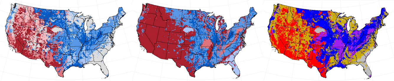
When aggregated to larger regions and evaluated over longer time periods, trends in groundwater and surface water quantity aligned more closely, although a pattern of increasing low flow and declining groundwater persisted. The strongest agreement emerged when sites were grouped by Hydrologic Landscape Regions, suggesting that a combination of climate, topographic relief, and geology offers the best window into how surface and subsurface water systems respond together.
Areas that had similar wetting trends between groundwater and surface water tended to have low soil and bedrock permeability, flatter terrain, and relatively high baseflow fraction, which indicates that groundwater recharge is an important part of streamflow. Climate also affected trends, with arid regions in the Western U.S. showing more agreement on decreasing water quantity trends and moderately humid areas such as the Midwest and Eastern U.S. showing more agreement on wetting trends.
Joint trend analysis of streamflow and groundwater on a national scale is a critical step toward understanding how national water budget components respond concurrently and interactively to environmental drivers. Integrated water availability assessments may benefit from a framework that blends climate, topography, and geology to treat groundwater and surface water as a unified resource.