



USGS Awards $1.7 Million to 26 States to Preserve Data for Energy, Groundwater, Minerals Exploration
Funding will help states catalog and protect historic data also used to map hazards
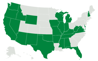
RESTON, Va. — The U.S. Geological Survey announced $1,685,806 in matching grants to 26 state geological surveys to inventory, catalog and preserve historic geoscientific data and physical samples critical to understanding the nation's energy, groundwater and mineral resources, and mapping geologic hazards like landslides.
“Geologic data are key to exploring for America’s energy, groundwater and minerals. These data include maps and reports that are sitting in government and corporate filing cabinets, desk drawers, and storage annexes all across the Nation. This kind of valuable information has usually been painstakingly produced by hand over the past two centuries of American geologic exploration. These USGS awards are our commitment to making all existing geologic data available to help explore for the Nation’s resources,” said USGS Director Ned Mamula.
As the United States works to strengthen domestic supply chains, the data and samples held in storage by state geological surveys have become increasingly valuable. These data help exploration geologists and hydrologists to identify new mineral potential, assess groundwater availability, and support infrastructure and hazard planning, often without the need for costly new fieldwork.
The grants come as national attention on data preservation grows. In August, the National Petroleum Council, an advisory committee of independent energy experts, highlighted the value of the USGS National Geological and Geophysical Data Preservation Program, which administers the grants, provided to address rising demand for secure domestic energy and mineral resources.
"As the need for domestic sources of critical minerals grows, so does the value of the data already collected and now sitting in state archives. These grants help our state partners unlock that value through better preservation, cataloging and digital access," said USGS Associate Director for Geology, Energy and Minerals Sarah Ryker.
Every federal dollar awarded is matched by state funding, doubling the investment and magnifying its impact. The program supports the preservation of crucial geological data and physical samples that enable future scientific discoveries related to critical minerals, groundwater resources and geologic hazards. In support of the USGS Earth Mapping Resources Initiative, the Data Preservation Program also facilitates the submission of up to 300 samples per State for geochemical analysis of existing materials with critical mineral potential.
Beyond preservation, the grants help modernize how this information is stored and shared. Improved physical storage conditions protect samples and cores for future research without the cost of reacquisition. Updating data formats and digital access, such as well log digitization and conversion to industry-standard formats supports web use by scientists, policymakers and the public.
The new National Geological and Geophysical Data Preservation Program Awards are:
- Alabama (Geological Survey of Alabama): Will relocate and catalog roughly 4,300 fossil specimens and 1,000 rock thin sections, and geochemically evaluate 150 rock, mineral, and core samples for critical mineral potential.
- Arkansas (Office of the State Geologist – Arkansas): Will inventory 120,000 historical water well construction reports, preserve cuttings in the Norman F. Williams well sample library, and submit up to 300 whole rock and borehole samples for critical mineral analysis.
- Arizona (University of Arizona – Arizona Geological Survey): Will build a web map of critical mineral samples, digitize the John Peterson mineral exploration collection, create a well cuttings digital repository, and sample drill core for geochemical analysis.
- California (California Geological Survey): Will modernize the California Well Sample Repository by creating a barcoded inventory and searchable database for 2,515 boxes of core, cuttings, and sidewall core from 1,738 wells.
- Delaware (Delaware Geological Survey): Will digitize and preserve historical Delaware Bay sediment-core and benthic sampling data through an online map interface.
- Florida (Florida Geological Survey): Will complete curation and cataloging of the Walter Schmidt Museum of Florida Geology's specimen collection, including stratigraphic reference samples.
- Iowa (Iowa Geological Survey): Will digitize at least 75 geophysical logs into LiDAR point cloud data files and submit 300 samples for whole-rock geochemical analysis of critical mineral potential.
- Idaho (Idaho Geological Survey): Will process and catalog Mines and Prospects, Mylars, and Images databases, develop new digital infrastructure, and submit 200 samples for critical mineral analysis.
- Illinois (Illinois State Geological Survey): Will combine two mismatched water well databases into one centralized, public database called ILLWATER.
- Indiana (Indiana Geological & Water Survey): Will stabilize and photograph damaged core boxes and paper records and update the statewide borehole-information system.
- Kentucky (University of Kentucky, Kentucky Geological Survey): Will catalog and digitize historic geologic maps related to critical minerals and energy resources, making them available through interactive map services.
- Michigan (Western Michigan University – Michigan Geological Survey): Will scan and digitally preserve evaporite drill cores using a new spectral gamma ray core logger, supporting critical mineral and energy assessments.
- Missouri (Missouri Department of Natural Resources, Missouri Geological Survey): Will photograph 1,250 boxes of core, build a core log database, and process whole-rock geochemistry samples.
- Mississippi (Mississippi Dept. of Environmental Quality, Office of Geology): Will preserve core and samples from 4 boreholes showing elevated lithium concentrations relevant to critical mineral exploration.
- New Hampshire (NH Dept. of Environmental Services – NH Geological Survey): Will digitize paper Water Well Inventory records for 20 municipalities in Hillsborough and Merrimack Counties.
- New Mexico (New Mexico Institute of Mining & Technology): Will develop a public web presence for the Mineral Museum, digitize drillers' logs, and support critical mineral data accessibility.
- Nevada (University of Nevada Reno – Nevada Bureau of Mines and Geology): Will digitize historic mining production ledgers and modernize core photography infrastructure at the Great Basin Science Sample and Records Library.
- Oklahoma (University of Oklahoma – Oklahoma Geological Survey): Will generate scanned digital content and inventory records for well data, core and cuttings samples, and critical minerals materials.
- Oregon (Oregon Department of Geology and Mineral Industries): Will continue organizing and digitizing historic assay records from DOGAMI's geochemical laboratories, adding thousands more to a searchable mineral database.
- Tennessee (Tennessee Geological Survey): Will add collections content to an ArcGIS web map, expand core repository storage, and compile critical mineral borehole data for the Mascot-Jefferson City District.
- Texas (University of Texas Bureau of Economic Geology): Will digitize geophysical logs from south Texas counties and provide samples for a statewide critical mineral assessment.
- Virginia (Virginia Department of Energy, Geology and Mineral Resources Program): Will reconcile its Rock Repository, digitize historic mining documents and maps, and conduct geochemical analyses for critical minerals characterization.
- Washington (Washington Geological Survey): Will preserve the Paul E. Hammond Collection, a 58-year career's worth of geologic mapping data for Washington State, including 7,000 physical samples.
- Wisconsin (University of Wisconsin–Madison – Wisconsin Geological and Natural History Survey): Will catalog large-format maps, shoreline erosion research materials, and update the Aquifer Properties Database.
- West Virginia (West Virginia Geological & Economic Survey): Will inventory, re-box, and photograph rock core samples and submit 300 samples for critical mineral geochemical analysis.
- Wyoming (Wyoming State Geological Survey): Will digitize legacy geologic maps of the South Pass granite-greenstone belt and submit 300 samples for critical mineral analysis.
The National Geological and Geophysical Data Preservation Program, administered by USGS, provides annual grants to state geological surveys to inventory, catalog and preserve geoscientific data and samples. Other organizations may participate by partnering with eligible state agencies. More information is available here.
###
The USGS provides science for a changing world. Learn more at https://www.usgs.gov or follow us on Facebook @USGeologicalSurvey, YouTube @USGS, Instagram @USGS, or X at @USGS.