



Media Alert: Low-level Flights to Image Geology over Western Idaho
USGS airborne survey will map critical minerals, energy resources, and earthquake hazards
RESTON, Va. – The U.S. Geological Survey plans low-level helicopter flights over western Idaho in October and early November to image geology using airborne geophysical technology.
The flights are a collaborative effort between the U.S. Geological Survey’s Earth Mapping Resources Initiative and the Idaho Geological Survey (IGS). The USGS Earth Mapping Resources Initiative is an effort to modernize the nation’s maps of geology and mineral resources, and to identify energy and groundwater resources and natural hazards.
"Partnership with state surveys helps accomplish national goals like mapping the critical minerals the U.S. needs. The Idaho Geological Survey is helping with the work of the nation—and adding to state knowledge crucial to water resources, hazards and the resource economy," said Jamey Jones, science coordinator for the U.S. Geological Survey's Earth Mapping Resources Initiative.
"The opportunity to focus USGS resources in western Idaho, in an area of renewed interest from the mineral industry, will significantly advance our understanding of the regional geology in this complex part of the state. The new geophysical data will support ongoing geologic mapping and research, help identify areas for further investigation, and strengthen Idaho’s ability to responsibly steward its economic and natural resources,” said Claudio Berti, State Geologist and Director of the Idaho Geological Survey.
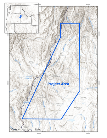
The survey will cover a portion of the Hitt Mountains, and Cuddy and Horse Mountain in west central Idaho. Historical mining records within the survey area indicate a broad distribution of critical minerals such as antimony, copper, gold, lead, manganese, molybdenum, silver and zinc. This survey extends prior Earth MRI surveys across Idaho designed to enhance the geologic characterization of Idaho’s unique critical mineral resources. In addition to mineral exploration, the survey provides baseline data for future earth-science studies, such as those related to geologic hazards or groundwater assessments.
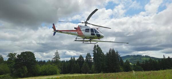
The survey includes magnetic and radiometric data collection from helicopters along pre-planned flight lines spaced 660 feet (200 meters) apart at a nominal terrain clearance of 330 feet (100 meters). The USGS has contracted NRG Exploration USA Inc. and Woolpert to collect the airborne magnetic and radiometric data. Their AS350 helicopters will be equipped with an elongated “stinger” that extends from the main cabin or helicopter skids and houses sensors collecting data. These scientific instruments are completely passive with no emissions that pose a risk to humans, animals, or plant life. No photography or video data will be collected. The aircraft will be flown by experienced pilots who are specially trained and approved for low-level flying. These pilots work with the FAA to ensure flights are safe and in accordance with U.S. law. The surveys will be conducted during daylight hours only.
Flights will be based out of Council Municipal Airport (U82) and will fly over the following counties: Adams and Washington in Idaho, locally edging into Baker and Wallowa in Oregon.
Earth MRI includes airborne geophysical surveys like this one, geochemical reconnaissance surveys, topographic mapping using LiDAR technology, hyperspectral surveys, and geologic mapping projects. The data collected are made freely available to the public on the USGS ScienceBase website.

###
The USGS provides science for a changing world. Learn more at https://www.usgs.gov or follow us on Facebook @USGeologicalSurvey, YouTube @USGS, Instagram @USGS, or X at @USGS.