
Volcano Watch — Volcanic explosions provide the foundation for agriculture
The ash deposits on the southeastern part of the Island of Hawai‘i have fortuitously presented an agricultural opportunity in an otherwise rocky and hilly landscape. An underappreciated fact is that the explosive nature of our volcanoes provided this opportunity.
Around Pāhala are several ash layers comprised of fine-grained volcanic deposits, generally called “soil.” The ashes are a mixture of altered glass, rare vitric (glassy) shards, Pele's hair, pumice, and olivine crystals. They are derived from pristine ash-fall deposits, weathered and reworked ash, and sediments. Ancient soil horizons are present in some localities.
In dry areas, these ashy soils are friable, in some places dense and compact, but in most cases, they are sandy, loose, and dusty. In higher-rainfall areas, the ash appears clay-like. The clay was important to the sugar industry, not only as a growing medium, but also as a control on groundwater circulation in the region.
Collectively, these ash deposits were, in many ways, the underpinnings of the Ka‘ū sugar cane industry. The soils formed from these ashes sustained cane growth on relatively young flows, especially on the southeastern part of the Big Island. Volcanic ash has been interlayered with the agricultural development of the Pāhala to Nā‘ālehu region of the Big Island since the beginning of the plantation era.
the weathered ash, which has transformed to clay, is semi-permeable and alters the flow of groundwater. Rain that falls on lava flows trickles through the flows until it encounters a weathered ash layer. Because the ash acts as a barrier, the water flows across the top of the ash in the form of underground streams.
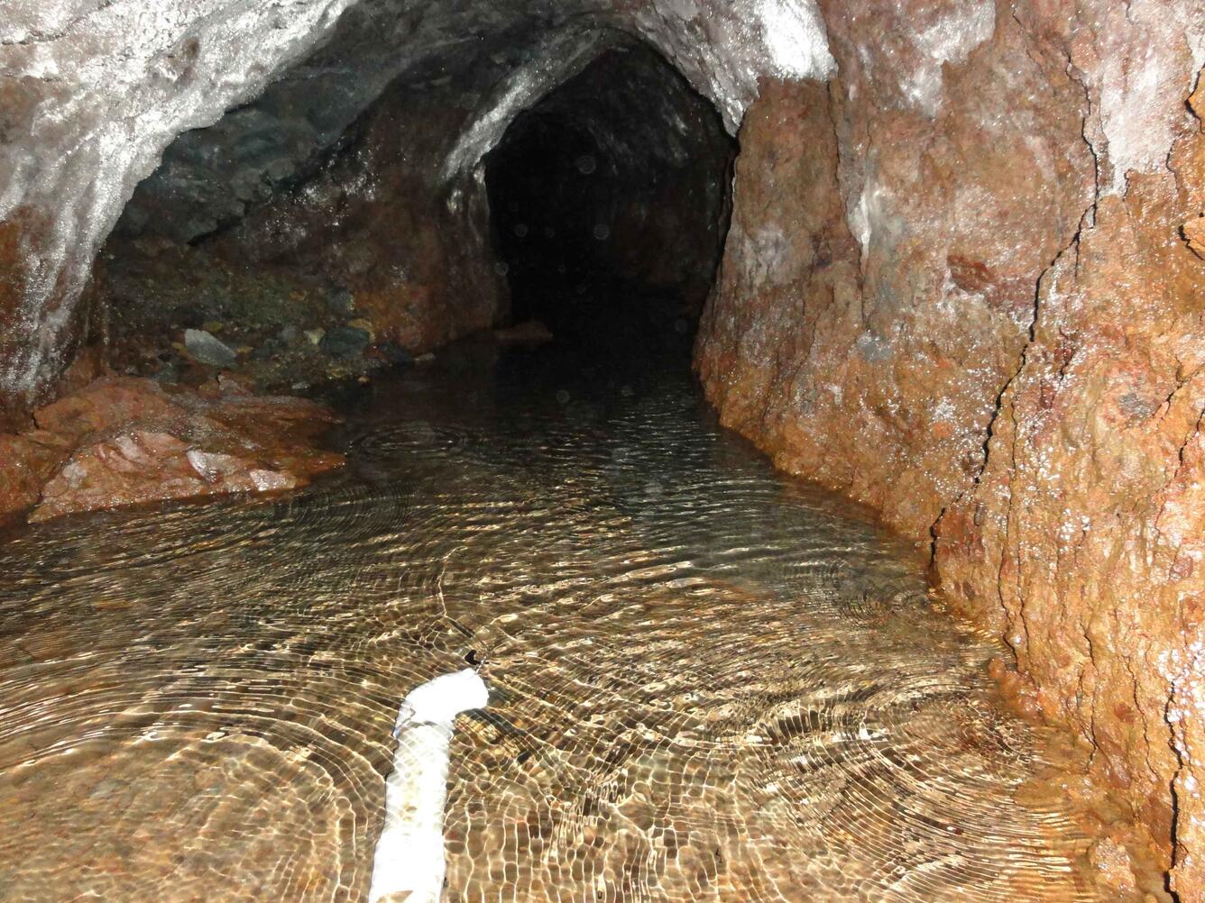
Hydrologists hired by plantations came to recognize that the ash beds were mostly impervious to water and would cause the rainfall to move horizontally. The ash layers mantled the existing topography, and water migrated to the low spots. Exploiting this fact, they constructed tunnels at the contact between the overlying flow and the underlying ash bed. The tunnels were built along the contour of the slope to intersect as many subterranean streams as possible.
Since it is easier to excavate ash than lava rock, most of the tunnels were dug within the ash layers. Due to the impervious nature of the ash, workers were careful, in their excavations, to keep the floor of the tunnel intact; otherwise, the floor had to be lined with concrete. Sometimes, where more than one ash horizon was stacked upon another, workers purposefully penetrated the overlying layers to harvest additional water.
In the plantation era, a great amount of effort and capital was invested in creating a series of water tunnels to capture groundwater. The tunnels have such names as Mountain House, Clark, Noguchi, Fukuda, Weda, ‘Alili, Makakupu, Plantation Spring, and MOAULA Gulch. Each supplied between 80,000 to 1,200,000 gallons of water per month.
The plantations were very pleased to have water for irrigation, but with annual rainfalls of 100-130 inches of rain per year, the water could be used for other purposes. In the early days of the plantation, from 1880 to 1948, bundles of sugar cane were floated to mills through flumes. In its heyday, the Nā‘ālehu sugar company had over 70 miles of permanent flumes floating cane to two mills—one at Honu‘apoand the other at Nā‘ālehu!
After 1948, roads and trucks were used to transport cane and the flume system was abandoned. Although the water was not used for the transport of cane, it remained a community resource for potable water and agricultural purposes.
Today, water from the Mountain House tunnel and Haao Springs is still used by the community. In addition, the Olson Trust is trying to obtain the necessary permits to use the water from tunnels closer to Wood Valley to generate electricity and irrigate crops.
The ash deposits on the southeastern part of the Island of Hawai‘i have fortuitously presented an agricultural opportunity in an otherwise rocky and hilly landscape. An underappreciated fact is that the explosive nature of our volcanoes provided this opportunity.
Volcano Activity Update
Kīlauea continues to erupt at its summit and East Rift Zone. This past week, the summit lava lake level varied between about 14 and 32 m (46 - 105 ft) below the vent rim. The 61g flow was still active, with lava entering the ocean near Kamokuna and small surface breakouts downslope of Puʻu ʻŌʻō, above the pali, and on the coastal plain. The 61g flows do not pose an immediate threat to nearby communities.
Mauna Loa is not erupting. During the past week, small-magnitude earthquakes continued to occur beneath the volcano, most commonly beneath the east flank at depths greater than 5 km (3 miles) and in the summit region, upper Southwest Rift Zone, and upper west flank at depths less than 5 km (3 miles). GPS measurements continue to show deformation related to inflation of a magma reservoir beneath the summit and upper Southwest Rift Zone. No significant change in the summit fumarole temperature or gas output was noted this past week.
Three earthquakes were reported felt on the Island of Hawai'i during the past week. On Friday, March 17 at 6:09 p.m. HST, a magnitude 3.5 earthquake occurred 11 km (7 mi) west of Waikoloa at a depth of 41 km (26 mi). On Sunday, March 19 at 2:17 p.m. HST, a magnitude 2.7 earthquake occurred 8 km (5 mi) southwest of Volcano at a depth of 33 km (20 mi). On Thursday, March 23 at 10:27 a.m. HST, a magnitude 4.4 earthquake occurred 10 km (6 mi) south of Volcano at a depth of 5 km (3 mi). The latter was the largest felt event of the week with 193 responses indicating a maximum intensity of V.
Visit the HVO website (http://hvo.wr.usgs.gov) for past Volcano Watch articles, Kīlauea daily eruption updates and other volcano status reports, current volcano photos, recent earthquakes, and more; call (808) 967-8862 for a Kīlauea summary update; email questions to askHVO@usgs.gov.
Volcano Watch (http://hvo.wr.usgs.gov/volcanowatch/) is a weekly article and activity update written by U.S. Geological Survey`s Hawaiian Volcano Observatory scientists and colleagues.