
Elevation-Derived Hydrography READ Rules: Connector: Terrain Breach
Used to breach terrain (or elevation) features that block the flow in a drainage network, such as a small rise in elevation, landslides, moraines, glacial till, or naturally formed berms. A Connector: Terrain Breach feature is used to breach flow blockages on the elevation surface; with no known built feature connecting upstream and downstream flow (Figure 49).
Use
In contrast, the Underground Conduit (FCode 42002) is used to represent an underground flowpath in known karst, permafrost, and thermokarst terrain; the culvert connector (FCode 33401) is used to connect upstream and downstream flow through a transportation feature; and connector (FCode 33400) is used to connect underground flow from upstream to downstream through built environments such as a dam.

Delineation
The limit of Connector: Terrain Breech is the virtual line connecting two nonadjacent network segments, extending from the lowest point on one side of the obstruction to a point at or below the starting point on the other side of the obstruction.
Representation Rules
Delineate features as points, lines, or polygons based on their area or length along different axes (Table 25).
| Kind of feature object | Area | Shortest Axis | Longest Axis |
| 0-dimensional (point) | -- | -- | -- |
| 1-dimensional (line) | -- | greater than 0 | -- |
| 2-dimensional (polygon) | -- | -- | -- |
Special Conditions
None.
Data Extraction
Capture Conditions
If Connector: Terrain Breach is required to maintain connectivity through a rise in elevation between two network feature objects,
then capture.
If Connector: Terrain Breach with a rise in elevation extends in length for three pixels or more than the source resolution (3 meters for lidar, 15 meters for IfSAR) within the terrain,
then capture.
Attribute Information
FClass 1—Hydrography feature defined within the collection criteria of the elevation-derived hydrography specifications.
FCode 33405—Connector: Terrain Breach (Used to breach terrain (or elevation) features that lock the flow in a drainage network, such as a small rise in elevation, landslides, moraines, glacial till, or naturally formed berms).
EClass 3— Linear feature used for breaching.
Source Interpretation Guidelines
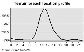
The following conditions indicate when and why the capture of Connector: Terrain Breach is required (Figure 50):
• When Connector: Terrain Breach is part of a network that is represented as connected.
• When there is a gap caused by a rise in elevation greater than or equal to 1 meter in lidar and greater than or equal to 2 meters in IfSAR.
Do not use the Connector: Terrain Breach feature type to represent underground flowpaths in known karst, permafrost or thermokarst terrain, see Underground Conduit in Appendix 1.
A Connector: Terrain Breach feature is not necessary:
• If the rise in elevation requires z-values along the linear feature to be less than 1 meter below the surface for lidar (Figure 51), or 2 meters below the surface for IfSAR source elevation, or
• If the rise in elevation extends in length for three pixels or less than the source resolution (3 meter for lidar, 15 meters for IfSAR) within the terrain.

Special Conditions
None.