
New 3D Elevation Program Fact Sheet for Tennessee
Learn about 3D Elevation Program (3DEP) lidar data for Tennessee in the new fact sheet -
The 3D Elevation Program - Supporting Tennessee's Economy
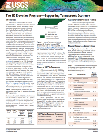
High-resolution elevation data are critical to Tennessee's economy, enabling state agencies, local governments, and the general public to enhance precision farming activities, implement natural resource management strategies, and identify landslide hazards and sinkholes.
Quality level 2 lidar is available across the State as a result of partnership with the U.S. Geological Survey through the 3D Elevation Program.
Download the new 3DEP State Fact Sheet to learn about available lidar and the many beneficial uses of the data. You can access the fact sheet through the linked button above and at the USGS publication page. Fact sheets for other states are also available in the 3DEP State Fact Sheet repository.
To view and access 3DEP lidar data, please visit the USGS LidarExplorer. To download these and other National Map products, please visit The National Map Downloader.