



Announcing Volcano Awareness Month Programs in January 2027!
Every January, the USGS Hawaiian Volcano Observatory organizes Volcano Awareness Month — a chance for all of us who live, work, or visit the Hawaiian Islands to learn about the volcanoes and earthquakes that shape this landscape.
Join us at one of the many free events being offered in January 2027 to commemorate the Island of Hawaiʻi's 18th annual Volcano Awareness Month.
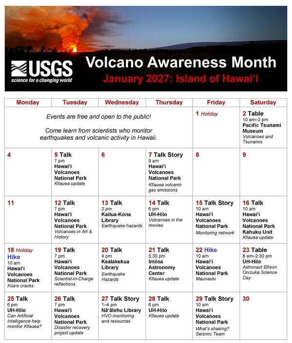
Saturday, January 2: TABLE
Volcanoes and Tsunamis—Come to Know the Flows
The USGS Hawaiian Volcano Observatory monitors earthquakes and volcanoes in Hawaii and American Samoa. Several local earthquakes within the past two centuries have generated local tsunamis in Hawaii. Join USGS-Hawaiian Volcano Observatory geologist Kendra J. Lynn and field engineer Miki Warren as they share volcano and earthquake resources during the Pacific Tsunami Museum First Saturday free admission event, which honors volcanic heritage, explores the connection between volcanoes and tsunamis, and promotes community awareness and preparedness.
- When: 10 a.m.–2 p.m.
- Where: Pacific Tsunami Museum, 130 Kamehameha Avenue, Hilo, HI 96720 (https://tsunami.org/)
Tuesday, January 5: TALK
Kīlauea update: Eruptions, insights, and what’s next...
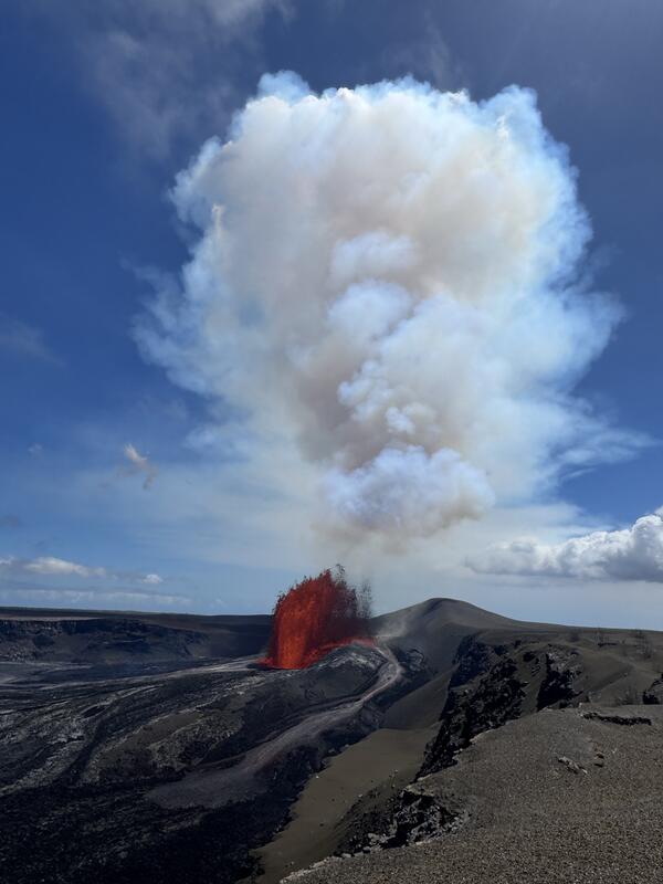
More than 50 episodes of lava fountains erupted within the summit caldera of Kīlauea since December 23, 2024. Scientists have been able to provide forecast windows for when fountaining could start, and they document changes to the landscape, including growth of a cone on the crater rim and tephra deposits downwind. The tallest lava fountains in the first part of 2026 resulted in tephra fall in areas around Kīlauea summit, causing temporary closures of Hawaiʻi Volcanoes National Park and Highway 11. In August 2026, activity shifted away from lava fountaining, with new vents passively erupting on the caldera floor briefly in September and an intrusion beneath the surface accompanied by earthquakes and new ground cracks at the beginning of October. How was this activity monitored? What does this shift in eruptive style mean? What might Kīlauea do next? Join USGS Hawaiian Volcano Observatory geologist Mike Zoeller as he answers these questions and more. Variations of this presentation will be repeated by different speakers at the Kahuku Unit of Hawaiʻi Volcanoes National Park on January 16, Imiloa Astronomy Center on January 21, and the University of Hawaiʻi at Hilo on January 28.
- When: 7 p.m.
- Where: Kīlauea Visitor Center Auditorium in Hawaiʻi Volcanoes National Park, 1 Crater Rim Drive, Volcano, HI 96785 (entrance fees may apply, https://www.nps.gov/havo/planyourvisit/directions.htm)
Thursday, January 7: TALK STORY
Kīlauea’s summit volcanic gas emissions & monitoring challenges
During and between eruptive episodes at the summit of Kīlauea, volcanic gas is emitted. The amounts vary greatly depending on eruptive activity, and challenges to measuring emission rates have been introduced by shifting wind conditions, access roads being buried by tephra, and monitoring equipment being buried and damaged. As sulfur dioxide is transported downwind, it reacts in the atmosphere to form the visible haze that is observed downwind of Kīlauea, known as vog. Come talk story with USGS-Hawaiian Volcano Observatory volcano gas specialist Tricia Nadeau, as she describes the gas characteristics of Kīlauea and the far-reaching hazards associated emissions.
- When: 9 a.m.
- Where: Uēkahuna Overlook in Hawaiʻi Volcanoes National Park (entrance fees may apply, https://www.nps.gov/havo/planyourvisit/directions.htm)
Tuesday, January 12: TALK
Volcanoes in art and history
What do Mary Shelley's Frankenstein, impressionist art, the French Revolution, and the Panama Canal have in common? They were all influenced by volcanic activity! Volcanoes impact where people live, what people eat, art, literature, and even the outcomes of wars in ways we don’t often think about. Join University of Hawai‘i at Hilo geology professor Lis Gallant as she highlights the deep ties between art, history, and volcanoes and breaks down the science behind what has captivated humans for millennia.
- When: 7 p.m.
- Where: Kīlauea Visitor Center Auditorium in Hawaiʻi Volcanoes National Park, 1 Crater Rim Drive, Volcano, HI 96785 (entrance fees may apply, https://www.nps.gov/havo/planyourvisit/directions.htm)
Wednesday, January 13: TALK
When the ground shakes: understanding earthquake hazards in Hawaii
The magnitude-6 earthquake beneath the west side of the Island of Hawaiʻi on May 22 this year was felt statewide. It damaged homes, triggered rockfalls, and caused power outages. This earthquake was just one among tens of thousands of earthquakes that occur each year in Hawaii, which is one of the most seismically active places in the United States. Join Ninfa Bennington, USGS Hawaiian Volcanic Observatory seismologist, as she talks about the different types of earthquakes in Hawaii and which have been most damaging in the recent past. Learn how earthquakes are monitored, how you can participate in the process of earthquake monitoring and ways that you can prepare and react when you experience the ground shaking. This presentation will be repeated by a different speaker at the Kealakekua Public Library on January 20.
- When: 2 p.m.
- Where: Kailua-Kona Public Library, 75-138 Hualalai Rd, Kailua Kona, HI 96740 (https://www.librarieshawaii.org/branch/kailua-kona-public-library/)
Thursday, January 14: TALK
Lights, camera, action! Volcanoes in the movies
What happens when you mix Hollywood and volcanoes? We’ll examine how volcanic eruptions are portrayed on the silver-screen and separate cinematic fiction from scientific fact. Join University of Hawaiʻi at Hilo geology professor Thomas Lee for an entertaining look at whether blockbuster favorites such as Dante's Peak and Volcano get a passing grade in Geology!
- When: 6 p.m.
- Where: University of Hawaiʻi at Hilo Wentworth Building (Bldg 348) Room 1, Main Campus, 200 West Kawili Street, Hilo, HI 96720 (https://hilo.hawaii.edu/uhh/maps.php)
Friday, January 15: TALK STORY
Talk Story with HVO Field Engineers
Field engineers maintain the network of instrumentation in Hawaii that allows scientists to monitor volcanic activity below and above the ground surface. Eruption and weather-related challenges to maintaining instrumentation over the past year have included tephra fall from lava fountains at the summit of Kīlauea, which have buried monitoring equipment and shattered solar panels, as well as historic Kona Low storms and hurricanes that affected the network telemetry. Join USGS Hawaiian Volcano Observatory field engineers Kevan Kamibayashi and Miki Warren as they describe creative solutions to these challenges, which enable scientists to continue monitoring volcanic activity.
- When: 10–11 a.m.
- Where: Uēkahuna Overlook in Hawaiʻi Volcanoes National Park (entrance fees may apply, https://www.nps.gov/havo/planyourvisit/directions.htm)
Saturday, January 16: TALK
Kīlauea update: Eruptions, insights, and what’s next…
More than 50 episodes of lava fountains erupted within the summit caldera of Kīlauea since December 23, 2024. Scientists have been able to provide forecast windows for when fountaining could start, and they document changes to the landscape, including growth of a cone on the crater rim and tephra deposits downwind. The tallest lava fountains in the first part of 2026 resulted in tephra fall in areas around Kīlauea summit, causing temporary closures of Hawaiʻi Volcanoes National Park and Highway 11. In August 2026, activity shifted away from lava fountaining, with new vents passively erupting on the caldera floor briefly in September and an intrusion beneath the surface accompanied by earthquakes and new ground cracks at the beginning of October. How was this activity monitored? What does this shift in eruptive style mean? What might Kīlauea do next? Join USGS Hawaiian Volcano Observatory geologist Natalia Deligne as she answers these questions and more. Variations of this presentation will be repeated by different speakers at Hawaiʻi Volcanoes National Park on January 5, Imiloa Astronomy Center on January 21, and the University of Hawaiʻi at Hilo on January 28.
- When: 10 a.m.
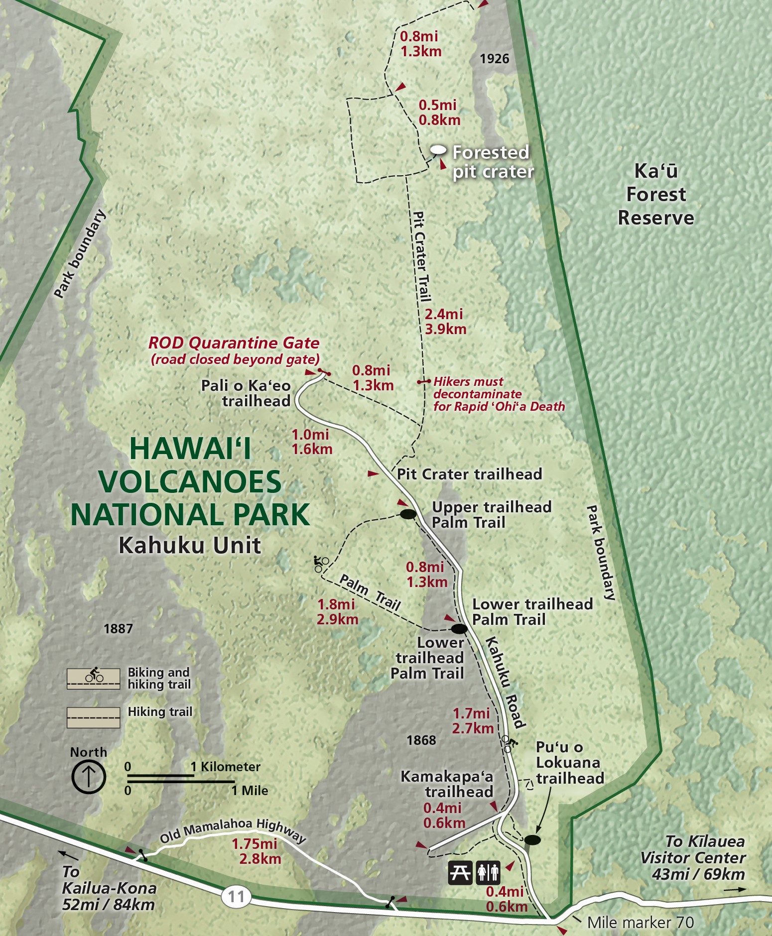
- Where: Kahuku Unit Visitor Contact Station, Hawaiʻi Volcanoes National Park, mile marker 70.5 on Highway 11 (https://www.nps.gov/havo/images/HAVO_Kahuku-Map.jpg)
Monday, January 18: GUIDED HIKE
Following the cracks: the Koaʻe fault system of Kīlauea
The Koa‘e fault system connects Kīlauea’s East and Southwest Rift Zones south of the caldera. Faults here appear as low cliffs, or “scarps” along Hilina Pali Road in Hawai‘i Volcanoes National Park and the area provides an important long-term record of Kīlauea south flank motion. These fault slip during major earthquakes, such as those of May 4, 2018—near the beginning of Kīlauea’s 2018 eruption. Join University of Hawai‘i at Hilo geology professor Steve Lundblad as he describes how geology students track ground movements in the Koa‘e fault system, measuring active faults and tracking magmatic intrusions. Explore the fault system on-the-ground and learn how measurements complement USGS Hawaiian Volcano Observatory geodetic instruments to keep track of this active part of the Kīlauea volcano.
- When: 10 a.m.–12 p.m.
- Where: Kulanaokuaiki Campground in Hawaiʻi Volcanoes National Park (entrance fees may apply, https://www.nps.gov/havo/planyourvisit/directions.htm)
- Amenities: vault toilet at the parking lot; no running water
- Estimated distance: 1 mile (1.6 km) round-trip
- Walk rating: easy, but crosses loose, gravel-like lava fragments and rough, uneven surfaces
- For your safety: wear sturdy closed-toe walking shoes; bring protective gear for sun and rain; bring drinking water
- More info: https://www.nps.gov/havo/planyourvisit/kulanaokuaiki-campground.htm
Tuesday, January 19: TALK
An eruptive tenure: reflections on six years as Scientist-in-Charge
After six years leading the USGS Hawaiian Volcano Observatory, Ken Hon will retire in December 2026. Ken’s career spans nearly four decades—from the Puʻuʻōʻō eruption on the East Rift Zone of Kīlauea in the late 1980s to leading the observatory through nine eruptions at Kīlauea and Mauna Loa and thousands of earthquakes across Hawaii and American Samoa between 2020–2026. Under Ken’s leadership, the USGS Hawaiian Volcano Observatory launched its first livestreaming cameras, expanded monitoring networks, strengthened partnerships, and supported communities through rapidly changing volcanic conditions. He also helped move forward new USGS facilities that will serve future generations of scientists. Join Ken Hon, former Scientist-in-Charge at the USGS Hawaiian Volcanic Observatory, as he reflects on the activity and challenges during his tenure of leadership at the observatory.
- When: 7 p.m.
- Where: Kīlauea Visitor Center Auditorium in Hawaiʻi Volcanoes National Park, 1 Crater Rim Drive, Volcano, HI 96785 (entrance fees may apply, https://www.nps.gov/havo/planyourvisit/directions.htm)
Wednesday, January 20: TALK
When the ground shakes: understanding earthquake hazards in Hawaii
The magnitude-6 earthquake beneath the west side of the Island of Hawaiʻi on May 22 this year was felt statewide. It damaged homes, triggered rockfalls, and caused power outages. This earthquake was just one among tens of thousands of earthquakes that occur each year in Hawaii, which is one of the most seismically active places in the United States. Join Jefferson Chang, USGS Hawaiian Volcanic Observatory seismologist, as he talks about the different types of earthquakes in Hawaii and which have been most damaging in the recent past. Learn how earthquakes are monitored, how you can participate in the process of earthquake monitoring and ways that you can prepare and react when you experience the ground shaking. This presentation will be repeated by a different speaker at the Kailua-Kona Public Library on January 13.
- When: 4 p.m.
- Where: Kealakekua Public Library, 81-6619 Hawaii Belt Rd, Kealakekua, HI 96750 (https://www.librarieshawaii.org/branch/kealakekua-public-library/)
Thursday, January 21: TALK
Kīlauea update: Eruptions, insights, and what’s next…
More than 50 episodes of lava fountains erupted within the summit caldera of Kīlauea since December 23, 2024. Scientists have been able to provide forecast windows for when fountaining could start, and they document changes to the landscape, including growth of a cone on the crater rim and tephra deposits downwind. The tallest lava fountains in the first part of 2026 resulted in tephra fall in areas around Kīlauea summit, causing temporary closures of Hawaiʻi Volcanoes National Park and Highway 11. In August 2026, activity shifted away from lava fountaining, with new vents passively erupting on the caldera floor briefly in September and an intrusion beneath the surface accompanied by earthquakes and new ground cracks at the beginning of October. How was this activity monitored? What does this shift in eruptive style mean? What might Kīlauea do next? Join USGS Hawaiian Volcano Observatory acting Scientist-in-Charge David Phillips as he answers these questions and more. Variations of this presentation will be repeated by different speakers at Hawaiʻi Volcanoes National Park on January 5, the Kahuku Unit of Hawaiʻi Volcanoes National Park on January 16, and the University of Hawaiʻi at Hilo on January 28.
- When: 5:30 p.m.
- Where: Imiloa Astronomy Center, 600 Imiloa Place, Hilo, HI 96720 (entrance fees may apply, https://imiloahawaii.org/)
Friday, January 22: GUIDED HIKE
Hike where lava fountained and flowed: the 1969–74 Maunaulu eruption
Volcanologist Cheryl Gansecki will lead a guided walk beginning along the fissure that started the Maunaulu eruption on the upper East Rift Zone of Kīlauea on May 24, 1969. The eruption went on for another five years and was characterized by 12 lava fountaining episodes that transitioned to continuous eruption of lava flows which eventually reached the ocean. The eruption ultimately built a lava shield, Maunaulu (“growing mountain”). The first part of the walk is an exploration of the initial fissures and remarkable volcanic features in the area for about 1 hour/1 mile (1.6 km). For those wanting a little more adventure, the hike will then continue to the Maunaulu shield and explore features such as a perched pond, lava channels and summit crater. That part of the walk will be an additional 2 hours and 2.8 miles (4.5 km) roundtrip. During the walk, Cheryl will describe the Maunaulu eruptions and discuss how fissures form, lava fountains erupt, and how these eruptions create the landscape you see.
- When: 10 a.m.–11 a.m. or 1:00 p.m.
- Where: Maunaulu in Hawaiʻi Volcanoes National Park (entrance fees may apply, https://www.nps.gov/havo/planyourvisit/directions.htm)
- Amenities: vault toilet at the parking lot; no running water
- Estimated distance: 1 mile (1.6 km) or 4 miles (6.4 km) total round-trip (with optional longer hike)
- Walk rating: easy, but crosses loose, gravel-like lava fragments and rough, uneven surfaces; longer hike is moderate with about 240 feet (75 meters) of elevation change
- For your safety: wear sturdy closed-toe walking shoes; bring protective gear for sun and rain; bring drinking water and snacks or lunch if you plan to do the longer hike option
- More info: https://www.nps.gov/havo/planyourvisit/upload/mauna_ulu_trail_guide.pdf and https://www.nps.gov/havo/planyourvisit/hike_day_puuhuluhulu.htm
Saturday, January 23: BOOTH
Ellison Onizuka Day
With the blessing of the Onizuka family, the team at the Pacific International Space Center for Exploration Systems (PISCES), along with the Hawaii Science and Technology Museum, invite you to participate in Astronaut Ellison Onizuka Science Day at the University of Hawai’i at Hilo on January 23, 2027! This free, family friendly event is open to the public and will feature exciting exhibits from local organizations and companies, plus fun, hands-on workshops for keiki in grades 3-12. USGS Hawaiian Volcano Observatory field engineers Miki Warren and Raymond Adams, both graduates of the University of Hawaiʻi at Hilo, will be hosting a table with volcano information at this event. More information on this event is available at: https://pacificspacecenter.com/onizuka-science-day/.
- When: 8 a.m.–2:30 p.m.
- Where: University of Hawaiʻi at Hilo main campus, 200 West Kawili Street, Hilo, HI 96720 (https://hilo.hawaii.edu/uhh/maps.php)
Monday, January 25: TALK
Can Artificial Intelligence help monitor Kīlauea?
VULCAN-AI is a University of Hawaiʻi (UH) research project exploring where artificial intelligence can support volcano monitoring. In this talk, a student team from UH-Hilo and UH-Mānoa, including Kye Steele, Samuel Watson, and Cee Cee Crabtree, shares what they are building using data and updates from the USGS Hawaiian Volcano Observatory (HVO): tools that help count, compare, and explain data, with every result checked against the observatory’s official record. We will be honest about what worked, what did not, and why authoritative forecasts and warnings stay with HVO. Bring your questions about how these tools work, what they can and cannot see, and how they might help the people who live with Kīlauea.
- When: 6 p.m.
- Where: University of Hawaiʻi at Hilo Wentworth Building (Bldg 348) Room 1, Main Campus, 200 West Kawili Street, Hilo, HI 96720 (https://hilo.hawaii.edu/uhh/maps.php)
Tuesday, January 26: TALK
The road to recovery: an update on projects after the 2018 disaster
Following the destructive lower East Rift Zone eruption and summit collapse of Kīlauea in 2018, the U.S. Geological Survey and National Park Service were supported by the Additional Supplemental Appropriations for Disaster Relief Act of 2019 (H.R. 2157) for recovery and rebuilding activities. Join Hawaiʻi Volcanoes National Park environmental protection specialist Danielle Foster and USGS Hawaiian Volcano Observatory acting Scientist-in-Charge David Phillips as they describe progress on various recovery projects, including Kīlauea Visitor Center renovations and construction of the USGS Hawaiian Volcano Observatory field station.
- When: 7 p.m.
- Where: Kīlauea Visitor Center Auditorium in Hawaiʻi Volcanoes National Park, 1 Crater Rim Drive, Volcano, HI 96785 (entrance fees may apply, https://www.nps.gov/havo/planyourvisit/directions.htm)
Wednesday, January 27: TALK STORY
Hawaiian Volcano Observatory resource table and talk story
Come talk story with USGS Hawaiian Volcano Observatory chief field engineer Kevan Kamibayashi as he hosts a table of resources from 1:00–4:00 p.m. at the Nāʻālehu Public Library. Do you have questions about the Kīlauea summit eruption, volcanic hazards, how eruptions are monitored, or what it’s like working for a volcano observatory? Kevan, who has worked for the Hawaiian Volcano Observatory for over 25 years, will be available to answer those questions and more. Come talk story, browse resources, and learn more about the volcanoes in your backyard.
- When: 1–4 p.m.
- Where: Nāʻālehu Public Library, 95-5669 Mamalahoa Highway, Naalehu, HI 96772 (https://www.librarieshawaii.org/branch/naalehu-public-library/)
Thursday, January 28: TALK
Kīlauea update: Eruptions, insights, and what’s next…
More than 50 episodes of lava fountains erupted within the summit caldera of Kīlauea since December 23, 2024. Scientists have been able to provide forecast windows for when fountaining could start, and they document changes to the landscape, including growth of a cone on the crater rim and tephra deposits downwind. The tallest lava fountains in the first part of 2026 resulted in tephra fall in areas around Kīlauea summit, causing temporary closures of Hawaiʻi Volcanoes National Park and Highway 11. In August 2026, activity shifted away from lava fountaining, with new vents passively erupting on the caldera floor briefly in September and an intrusion beneath the surface accompanied by earthquakes and new ground cracks at the beginning of October. How was this activity monitored? What does this shift in eruptive style mean? What might Kīlauea do next? Join USGS Hawaiian Volcano Observatory geologist Matt Patrick as he answers these questions and more. Variations of this presentation will be repeated by different speakers at Hawaiʻi Volcanoes National Park on January 5, the Kahuku Unit of Hawaiʻi Volcanoes National Park on January 16, and the Imiloa Astronomy Center on January 21.
- When: 6 p.m.
- Where: University of Hawaiʻi at Hilo Wentworth Building (Bldg 348) Room 1, Main Campus, 200 West Kawili Street, Hilo, HI 96720 (https://hilo.hawaii.edu/uhh/maps.php)
Friday, January 29: TALK STORY
What’s shaking? Seismic update
The Island of Hawaiʻi is among areas of the United States with the highest seismic hazard. The thousands of earthquakes that occur in the State of Hawaii each year are monitored by the USGS Hawaiian Volcano Observatory. Join USGS Hawaiian Volcano Observatory seismic analyst Peter Dotray and Research Corporation of the University of Hawaiʻi geophysicist Maddie Hawk, as they describe their role in determining an earthquake’s magnitude, location, and depth, as well as the network of instrumentation across the landscape that allows these determinations to be made.
- When: 10 a.m.
- Where: Wahinekapu (Steming Bluff) overlook in Hawaiʻi Volcanoes National Park (entrance fees may apply, https://www.nps.gov/havo/planyourvisit/directions.htm)