
Photo and Video Chronology — January 16, 2025 — Episode 4 of Kīlauea summit eruption continues
By Hawaiian Volcano Observatory
January 16, 2025
The summit eruption at Kīlauea volcano that began on December 23 entered its fourth eruptive episode yesterday morning at about 9:15 a.m. HST, and continues this morning.
Media
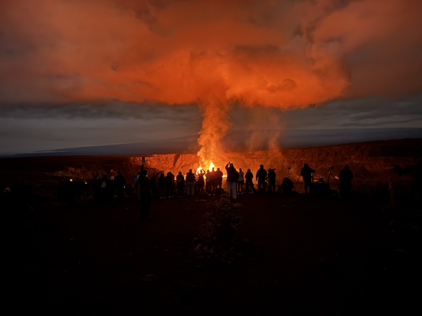
Early morning view of visitors gathered at Keanakākoʻi Overlook in Hawaiʻi Volcanoes National Park to view the ongoing Kīlauea eruption within Halema'uma'u in Kaluapele (the summit caldera). As of the morning on January 16, 2025, both the north and south vents are erupting lava fountains which are feeding lava flows in the southwest part of the caldera. The Keanakākoʻi Overloook is approximately 2.4 km (1.5 miles) away from the erupting vents. USGS photo by K. Mulliken.
Sources/Usage: Public Domain. View Media Details
Media
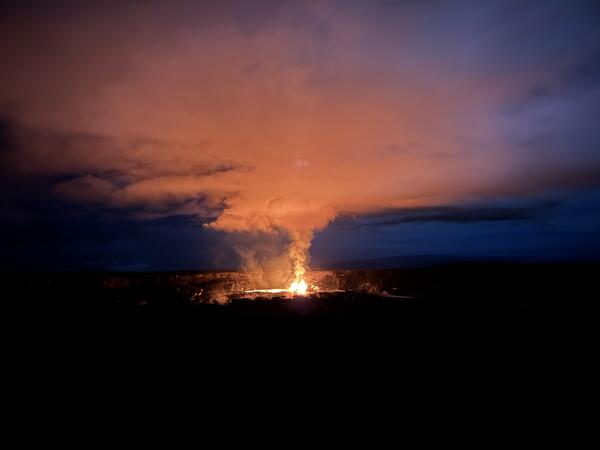
Early morning view of the ongoing Kīlauea eruption within Halema'uma'u in Kaluapele (the summit caldera) on January 16, 2025. This telephoto view is from the Volcano House overlook within Hawaiʻi Voclanoes National Park. USGS photo by K. Mulliken.
Sources/Usage: Public Domain. View Media Details
Media
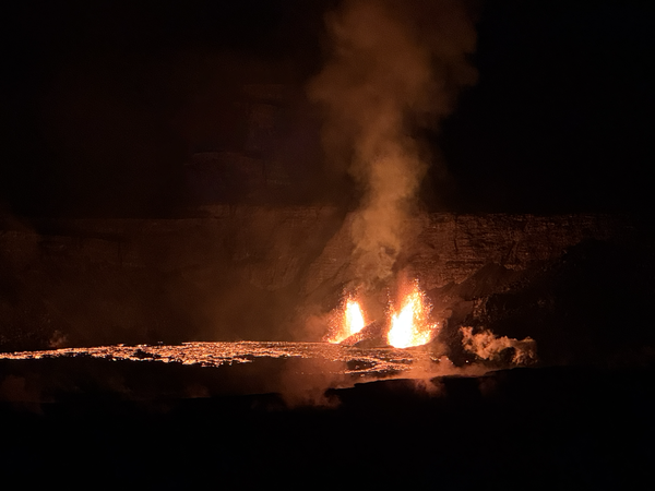
Telephoto view of the two vents erupting in the southwest part of Kīlauea summit caldera at approximately 6 a.m. HST. This view is to the southwest, from Volcano House within Hawaiʻi Volcanoes National Park. USGS photo by K. Mulliken.
Sources/Usage: Public Domain. View Media Details
Media
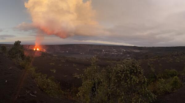
Panorama view of the Kīlauea summit eruption from Keanakākoʻi Overlook in Hawaiʻi Volcanoes National Park. The Keanakākoʻi Overlook is on the south side of Kaluapele (Kīlauea summit caldera) and the view is the northwest. On the left, the two erupting vents are visible within Halemaʻumaʻu in the southwest part of Kaluapele. The caldera walls behind the erupting vents are approximately 210 meters (690 feet) tall. Uēkahuna is visible as the highest part of the caldera wall near the center of the image. The steaming pali (cliffs) of the area that collapsed in 2018 (informally referred to as the downdropped block) is visible in the middle of the right side of the image, with the upper caldera floor extending to the right side of the image. Mauna Loa is visible in the background of the image. USGS photo by K. Mulliken.
Sources/Usage: Public Domain. View Media Details
Media
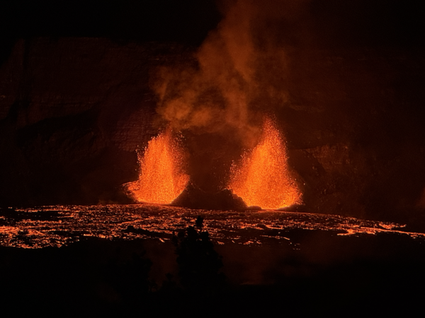
Telephoto view of the two vents erupting in the southwest part of Halema'uma'u in Kaluapele (Kīlauea summit caldera) at approximately 6 a.m. HST on January 16, 2025. USGS Hawaiian Volcano Observatory geologists in the field this morning measured the lava fountains as reaching approximately 60 meters (197 feet) high. Lava fountains are feeding lava flows that are active in Halemaʻumaʻu in the southwest part of the caldera. USGS photo by K. Mulliken.
Sources/Usage: Public Domain. View Media Details
Media
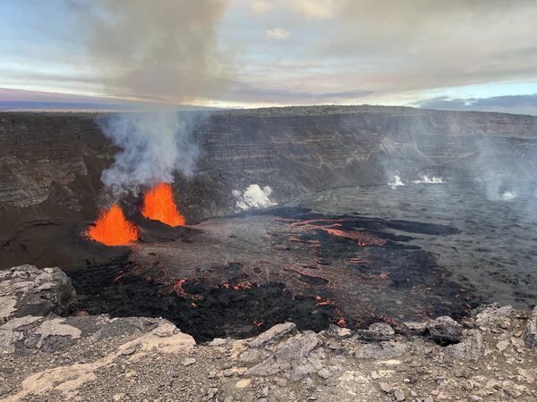
View of the Kīlauea summit eruption in Hawaiʻi Volcanoes National Park, from the south rim of the caldera. The caldera wall behind the erupting vents is approximately 210 meters (690 feet) tall. This morning, USGS Hawaiian Volcano Observatory field crews reported lava fountain heights of 50 meters (160 feet) and 40 m (140 feet) from north and south vents, respectively. At about 8:25 a.m. this morning, field crews reported that parts of the south vent collapsed, with an associated reduction of about half in south vent lava fountain height. Lava flow activity has remained confined to the southwest crater floor area near the active vents. USGS photo by K. Lynn.
Sources/Usage: Public Domain. View Media Details
Media
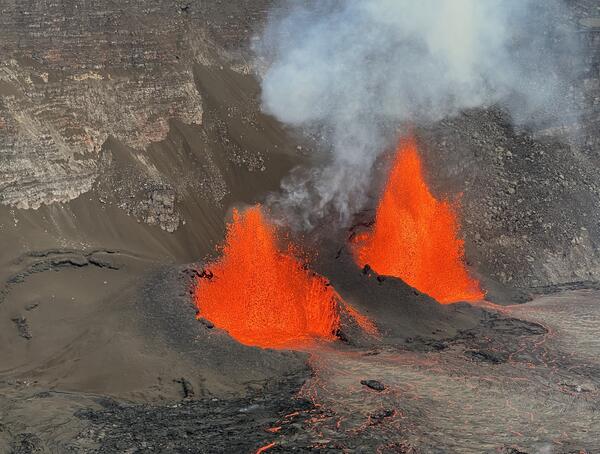
USGS Hawaiian Volcano Observatory scientists observe the continuation of the ongoing Kīlauea eruption during its fourth eruptive episode. The eruption had been paused since January 3, 2025, and resumed on January 15, 2025. Today, January 16, 2025, the south fountain (left) has an average height of about 40 meters (131 feet), and the north fountain (right) ranges in height between 50–60 meters (164–197 feet). Fountain heights have slightly decreased in height from yesterday's maximum measured fountain heights of 90–100 meters (295–328). USGS photo by H. Winslow.
Sources/Usage: Public Domain. View Media Details
Media
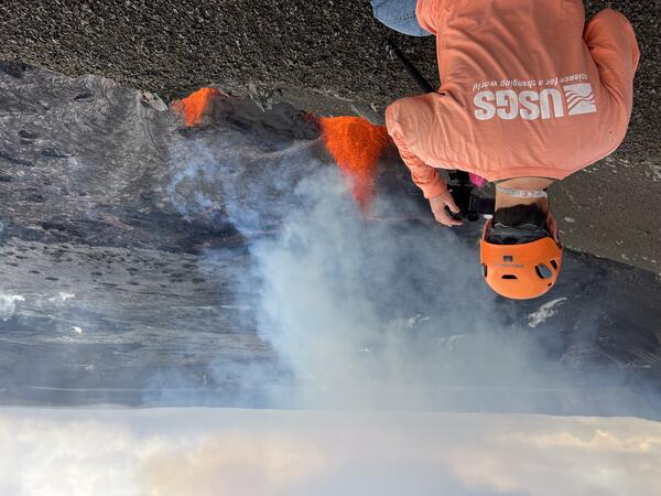
During the reactivation of the Kīlauea summit eruption, USGS Hawaiian Volcano Observatory scientists setup high resolution cameras to record eruption dynamics. While on field shifts, scientists measure fountain and cone heights, take thermal and observational images, and collect samples for monitoring purposes. During the field shift on January 16, 2025, staff were able to collect time-stamped airfall samples falling out of the plume. This photo is looking NE toward Volcano House from the west caldera rim. USGS photo by H. Winslow.
Sources/Usage: Public Domain. View Media Details