
Photo & Video Chronology — July 20, 2025 — Episode 29 at Kīlauea summit
By Hawaiian Volcano Observatory
July 22, 2025
Episode 29 of the ongoing Halemaʻumaʻu eruption ended at 6:35 p.m. HST, July 20, 2025, after over 13 hours of sustained lava fountaining.
Media

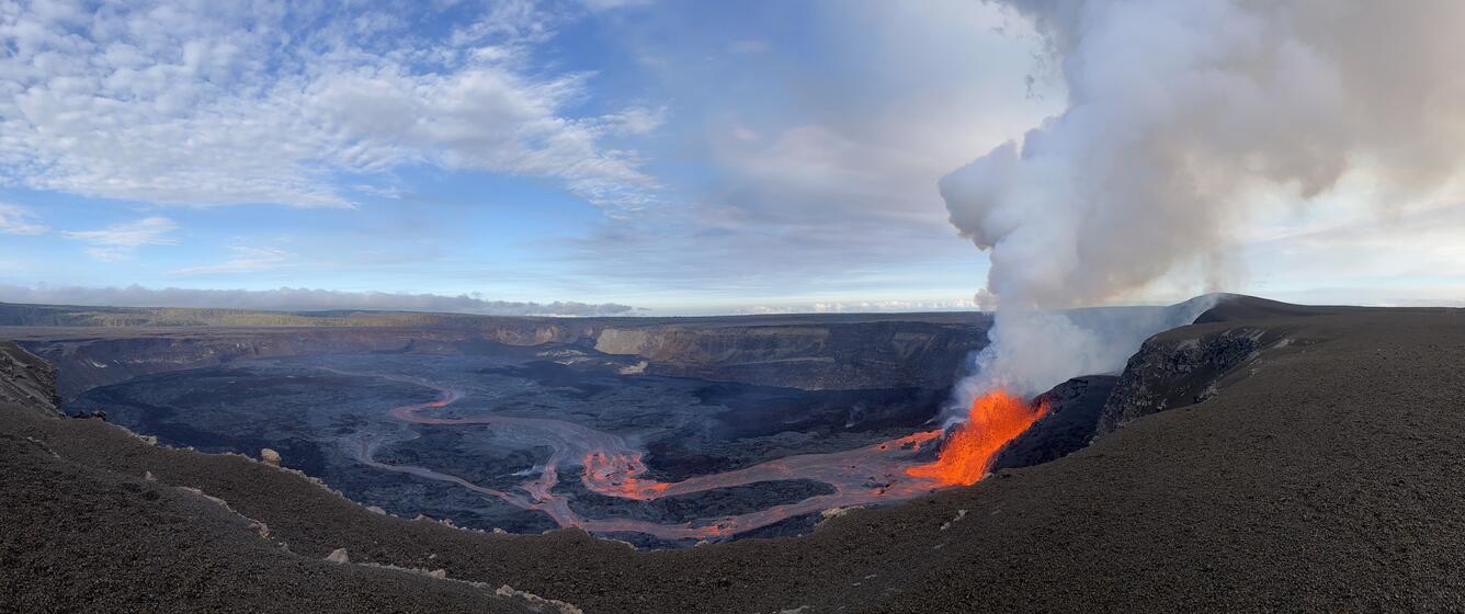
This view of episode 29 lava fountains within Halema‘uma‘u crater at the summit of Kīlauea was captured through the lens of a laser rangefinder device that USGS Hawaiian Volcano Observatory scientists were using to measure eruptive features. This photo was taken at 7:10 a.m. H.S.T. on July 20, 2025, nearly 2 hours after the start of episode 29. The north vent is at the center of the photo, and is noticeable wider than recent episodes. For scale, the prominent mound in front of north vent is approximately 27 meters (89 feet) high. The south vent was active for about 6 of the 13 hours of episode 29, and is seen here left (south) of north vent exhibiting low level fountaining. USGS photo by N. Deligne.
Sources/Usage: Public Domain. View Media Details
Media

During episode 29 of lava fountaining from the ongoing Kīlauea summit eruption, a USGS scientist uses a laser rangefinder from the caldera rim to measure the width and distance of lava channels—data that helps estimate the flow’s velocity. USGS staff visit this hazardous area with permission from Hawai‘i Volcanoes National Park. From this area of the crater rim, the team of scientists were able to record lava flowing at speeds of 16–20 feet per second (5–6 meters per second). USGS photo by N. Thomas.
Sources/Usage: Public Domain. View Media Details
Media

During episode 29 of lava fountaining at the ongoing Kīlauea summit eruption, USGS scientists approached the caldera rim—with permission from Hawai‘i Volcanoes National Park—to measure volcanic gas emissions. The lava fountain seen here, on the morning of July 20, reached approximately 100 feet (30 meters) high. Using an FTIR (Fourier Transform Infrared Spectroscopy) instrument, the team analyzed gases released during the eruption. Measuring volcanic gas composition and concentration helps scientists better understand magma storage and supports ongoing volcanic hazard assessments. USGS photo by M. Benage.
Sources/Usage: Public Domain. View Media Details
Media

Lava fountaining from episode 29 of the ongoing Halemaʻumaʻu eruption began around 5:15 a.m. HST on July 20. The eruption produced large lava flows from the north vent, which traveled approximately 1.5 miles (2.5 kilometers) across the caldera floor. USGS photo by M. Benage.
Sources/Usage: Public Domain. View Media Details
Media
Sources/Usage: Public Domain. View Media Details
Media

Sources/Usage: Public Domain. View Media Details