
Photo & Video Chronology — March 10 & 11, 2026 — Kīlauea episode 43 eruption and fallout
By Hawaiian Volcano Observatory
March 11, 2026
Over its 9‑hour duration, episode 43 generated significant tephra fall across Hawaiʻi Volcanoes National Park and nearby communities. The eruption prompted elevated alert levels, road closures and ash fall warnings as winds carried ash, Pele’s hair, and tephra to Puna, Hilo, and the Hamakua coast.
Media
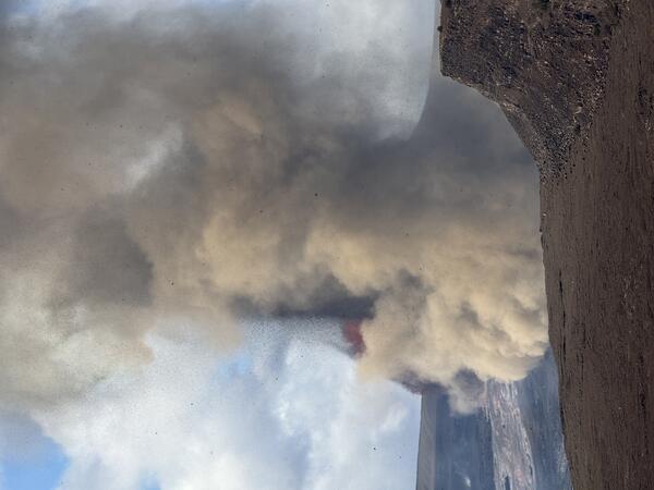
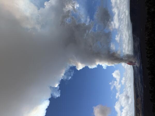
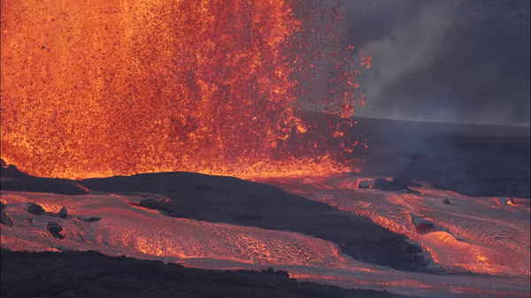
The onset of episode 43 fountaining of the ongoing Halemaʻumaʻu eruption at the summit of Kīlauea occurred at 9:17 a.m. HST on March 10, 2026, about an hour after the start of precursory eruptions at 8:20 a.m. HST. The start of episode 43 was marked by a sharp increase in tremor and deflationary tilt recorded at the Uēkahuna tiltmeter (UWD). At first, the north vent grew rapidly, exceeding 100 meters (330 feet) in height by 10:00 a.m. and both north and south vents exceeding 1000 feet (300 meters) by 10:50 a.m. HST. North and south vent fountain heights peaked shortly after 11:00 a.m. HST, with maximum fountain heights during the episode estimated to be at least 1300 feet (400 meters) from both vents. After about 12:00 p.m. HST, the south vent fountain remained consistently about 10-30 percent higher than the north vent fountains for the majority of the eruption. By 2:00 p.m. HST the south vent had dropped to 1000 feet (300 meters) high and the north vent about 700 feet (220 meters) high. By 5:00 p.m. fountain heights for the south and north vents had dropped to 700 feet (220 meters) and 600 feet (180 meters) respectively. Episode 43 lava fountaining from the north and south vents stopped at approximately 6:21 p.m. HST. USGS photo.
Sources/Usage: Public Domain. View Media Details
Media
Episode 43 of the Kīlauea summit eruption ended after about 9 hours with both the north and south vents active. The highest peak or instantaneous effusion rate of 1000 cubic yards (800 cubic meters) per second occurred around 10:30 a.m. HST on March 10. Episode 43 ended with an average effusion rate of 400 cubic yards per second (300 cubic meters per second). An estimated 16 million cubic yards (12 million cubic meters) of lava erupted and covered about 50% of Halemaʻumaʻu crater floor. The Uēkahuna tiltmeter (UWD) recorded about 33.7 microradians of deflationary tilt during episode 43. The total erupted volume since December 2024 is now close to 325 million cubic yards (250 million cubic meters). USGS photo.
Sources/Usage: Public Domain. View Media Details
Media
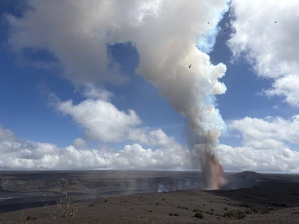
Episode 43 of the ongoing Kīlauea summit eruption occurred on March 10. Lava fountains from the north and south vents on the western side of Halema‘uma‘u crater floor produced a large eruption plume of volcanic gases and rock fragments (tephra). Tephra, ash, and pele’s hair fell to the north and east of the vents because of winds blowing from the southwest, which caused closures within Hawai‘i Volcanoes National Park and a section of Highway 11. Several small pieces of tephra are visible falling in this image. USGS photo taken on March 10, 2026, from Volcano House by L. DeSmither.
Sources/Usage: Public Domain. View Media Details
Media
On March 10, 2026, lava fountains erupted from two main vents within Halema‘uma‘u crater. During the ongoing episodic Kīlauea summit eruption, which began on December 23, 2024. There have been 43 episodes so far. USGS photo taken by L. DeSmither from Keanakāko‘i.
Sources/Usage: Public Domain. View Media Details
Media
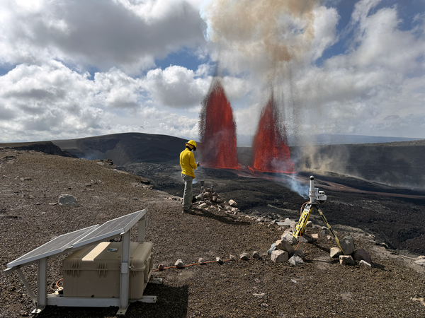
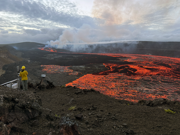
A USGS scientist performs maintenance on an eruption monitoring camera during episode 43 of the ongoing Kīlauea summit eruption. Work within this area, which is closed to the public, is done with permission from Hawai‘i Volcanoes National Park. USGS photo taken by L. DeSmither on March 10, 2026.
Sources/Usage: Public Domain. View Media Details
Media
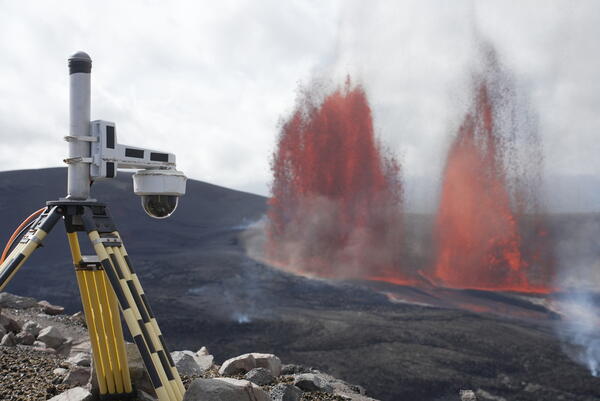
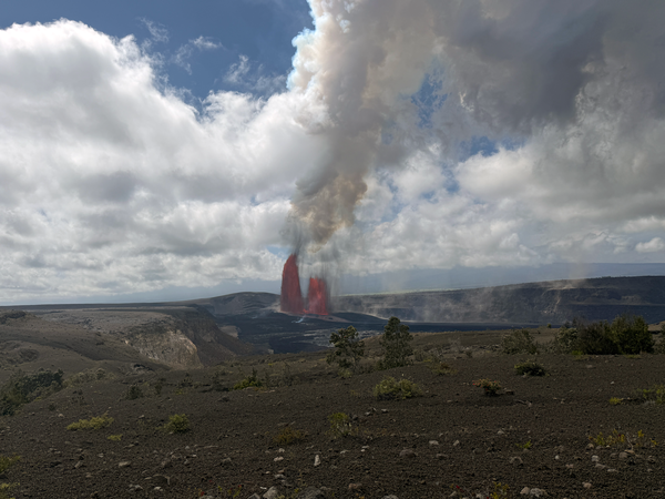
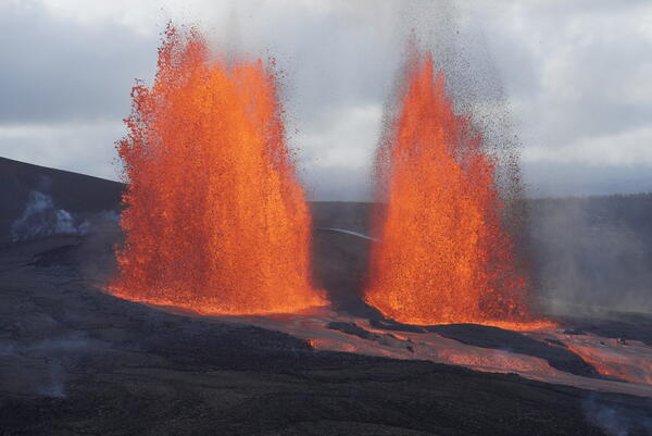
The V3cam is situated on the south rim of the caldera, at the summit of Kīlauea, and provides good views of the two separate fountains that have been active during the ongoing episodic eruption in Halemaʻumaʻu. This photo shows episode 43 lava fountaining activity with the south (left) and north (right) fountains active. USGS photo by M. Patrick.
Sources/Usage: Public Domain. View Media Details
Media
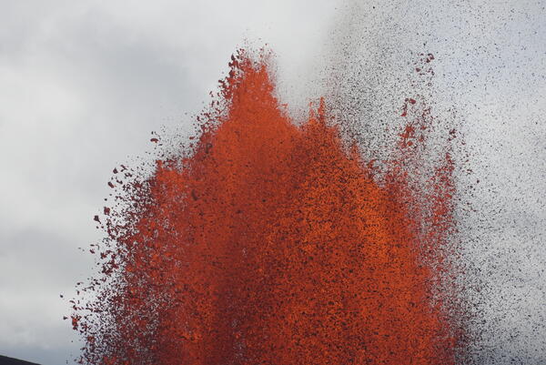
The top portion of the south lava fountain during episode 43 lava fountaining activity at the summit of Kīlauea, showing the range of sizes of clasts the separate out from the fountain. USGS photo by M. Patrick.
Sources/Usage: Public Domain. View Media Details
Media
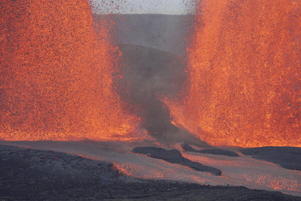
This photo shows the gap between the south (left) and north (right) lava fountains on March 10, 2026, as well as the lava channels that transport lava from the vent to the eastern crater floor. These fountains were active during episode 43 at the summit of Kīlauea. USGS photo by M. Patrick.
Sources/Usage: Public Domain. View Media Details
Media
Activity during the episode 43 lava fountains at the summit of Kīlauea, from the south rim of the crater. This area provided clear views of the north and south fountains, and the lava channels that transported lava from the vent into the eastern portion of the crater floor. USGS photo by M. Patrick.
Sources/Usage: Public Domain. View Media Details
Media
This photo shows the gap between the south (left) and north (right) lava fountains on March 10, 2026, as well as the lava channels that transport lava from the vent to the eastern crater floor. These fountains were active during episode 43 at the summit of Kīlauea. USGS photo by M. Patrick.
Sources/Usage: Public Domain. View Media Details
Media
This photo was taken from the south rim of Halemaʻumaʻu crater and shows the south and north fountains active during episode 43 at the summit of Kīlauea. USGS photo by M. Patrick.
Sources/Usage: Public Domain. View Media Details
Media
Episode 43 of the ongoing Halema‘uma‘u eruption at Kīlauea summit ended at 6:21 p.m. HST on March 10. About 15 minutes after the end of the episode, USGS scientists serviced a webcam near Keanakāko‘i on the southeast caldera rim. Active lava flows continued to slowly advance along the crater floor, and stand out here in the low lighting. The north and south vents (upper left) continue to emit a plume of volcanic gases and water vapor. USGS photo taken by L. DeSmither.
Sources/Usage: Public Domain. View Media Details
Media
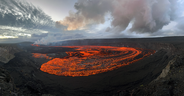
Episode 43, which began at 9:17 a.m. HST on March 10, erupted for just over 9 hours before pausing again at 6:21 p.m. This panoramic view of episode 43 lava flows on Halema‘uma‘u crater floor was taken a few minutes after the fountaining stopped. USGS photo taken by L. DeSmither near Keanakāko‘i on the southeast rim of the caldera.
Sources/Usage: Public Domain. View Media Details
Media
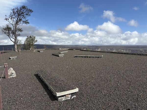
Episode 43 at the summit of Kīlauea was comparable in size to episodes 41 and 42, but due to light winds it produced tephra fallout similar to but not as great as episode 41. The plume sent tephra falling within Hawaiʻi Volcanoes National Park along the north rim of Kaluapele (Kīlauea caldera) and into adjacent communities. The heaviest tephra fall was recorded at Uēkahuna overlook in Hawaiʻi Volcanoes National Park, shown here, where 2-inch tephra began falling at around 10:20 a.m. HST and which received about 4-7 inches of accumulation total. USGS photo.
Sources/Usage: Public Domain. View Media Details
Media
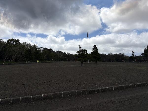
This photograph shows the grassy area around the flagpole at the Kilauea Military Camp in Hawaiʻi Volcanoes National Park. Tephra about 4-5 inches in diameter started falling at this location at about 10:20 a.m. HST, and in total the area received about 2 inches of accumulation that completely covered the ground surface. USGS photo.
Sources/Usage: Public Domain. View Media Details
Media
Fallout from Kīlauea episode 43 is continuing to be cleared as of the morning of March 11, 2026. This photo shows a pile of tephra that was cleared from a roadway in Kilauea Military Camp, in Hawaiʻi Volcanoes National Park, where the fallout continuously covered the ground. USGS photo.
Sources/Usage: Public Domain. View Media Details
Media
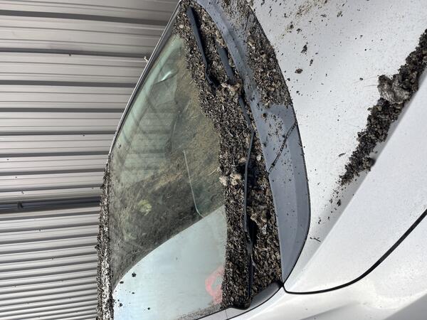
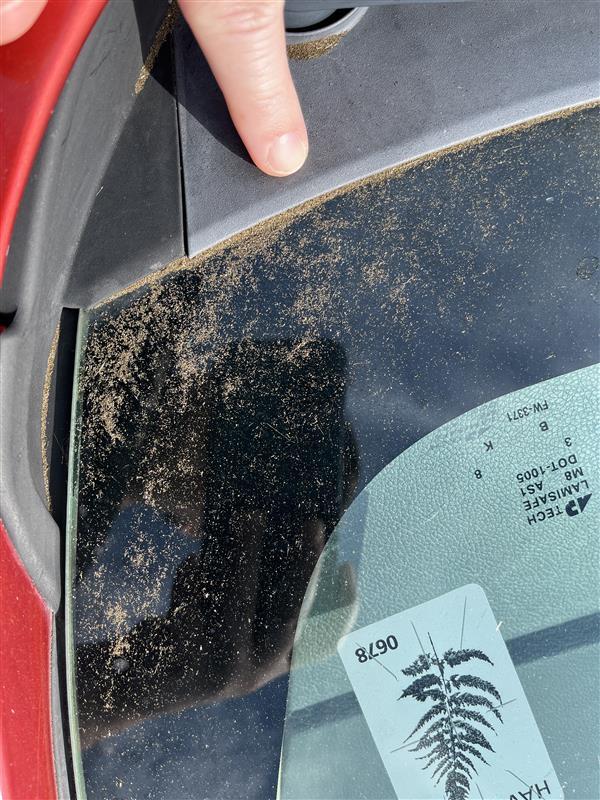
This car was parked within Hawai‘i Volcanoes National Park, nearly 3 miles (4.7 km) east-northeast of north and south vents of the ongoing eruption of Kīlauea volcano. The photo shows about 7 hours of tephra fall accumulation from episode 43. The owner of the vehicle was careful not to use the windshield wipers until the tephra had been removed to avoid scratching the windshield. USGS photo by N. Deligne.
Sources/Usage: Public Domain. View Media Details
Media
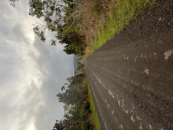
Episode 43 of Kīlauea's ongoing eruption occurred on March 10, 2026. This photo is taken on the Mauna Loa Road within Hawai‘i Volcanoes National Park, looking northwest. This photo shows the edge of the episode 43 tephra deposit. The tephra deposit (brown) on the road is nearly continuous where the photographer is standing, but disappears further along the road in the distance. USGS photo by N. Deligne.
Sources/Usage: Public Domain. View Media Details
Media
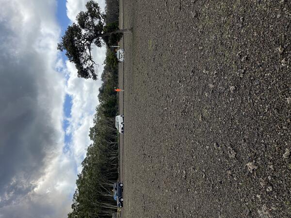
The Volcano Golf Course, located north-northeast of the eruptive vents at the summit of Kīlauea received fallout from episode 43 lava fountains that nearly continuously covered the ground with tephra particles up to several inches in diameter. USGS photo.
Sources/Usage: Public Domain. View Media Details
Media
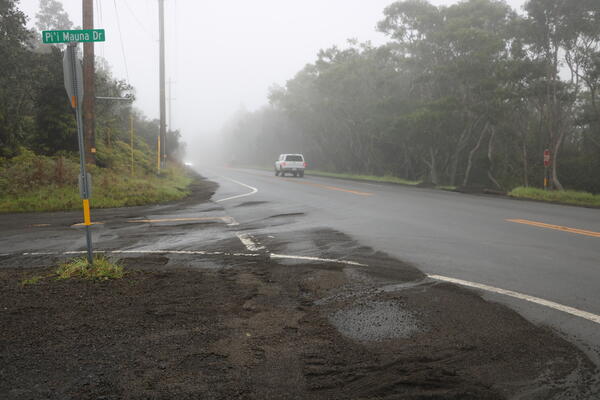
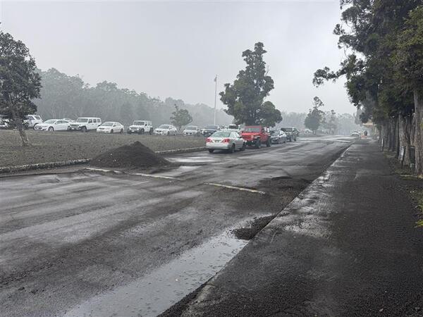
Highway 11 near Hawaiʻi Volcanoes National Park was affected by fallout from episode 43 lava fountains at the summit of Kīlauea on March 10, 2026. The Highway, which was nearly continuously covered with tephra, was closed on March 10 as material was cleared using heavy equipment. By the morning of March 11, the road had been re-opened and this photograph shows the remaining tephra on the shoulder near the turnoff to the Volcano Golf Course community, across from the Kilauea Military Camp. USGS photo.
Sources/Usage: Public Domain. View Media Details
Media
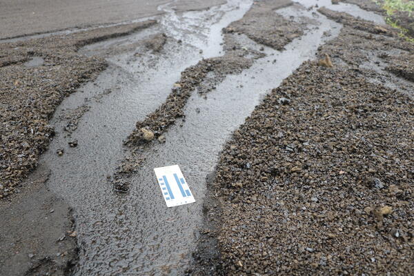
Heavy rainfall the evening of March 10-11 eroded pathways in the tephra deposit from Kīlauea episode 43 lava fountaining. This photo was taken near the Volcano Golf Course and shows the tephra fallout deposit and underlying road. USGS photo.
Sources/Usage: Public Domain. View Media Details
Media
Nearly 5 hours into episode 43 of the ongoing eruption at Kīlauea, the lawn at Kīlauea Military Camp was covered with about an inch of tephra (2 to 3 cm). The underlying grass was barely visible. The deposit included reticulite bombs (large foamy tephra clasts) mixed in with smaller denser lapilli tephra. USGS photo by N. Deligne.
Sources/Usage: Public Domain. View Media Details
Media
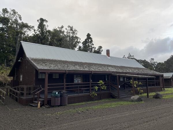
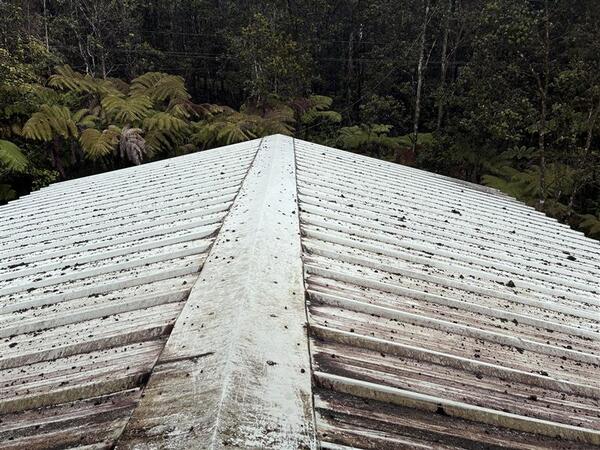
This building within Hawai‘i Volcanoes National park is nearly 3 miles (4.7 km) east-northeast of north and south vents of the ongoing eruption of Kīlauea volcano. Tephra from episode 41 and 43 lava fountains of the ongoing Kīlauea eruption was deposited on this building. The upper portion of the roof is steeper and so falling tephra slide down it. The lower part of the roof has a shallow enough slope to accumulate tephra. This photo was taken nearly 4 hours after the start of episode 43, but the tephra on the lower part of the roof is from both episodes 41 and 43. The tephra on the ground is almost entirely all from episode 43. USGS photo by N. Deligne.
Sources/Usage: Public Domain. View Media Details
Media
In Volcano Village, located northeast of the eruptive vents at the summit of Kīlauea, fallout from episode 43 was less extensive than the areas to the west. This photograph shows a parking area that nearly continuously covered with tephra particles ranging up to a couple inches in diameter. USGS photo.
Sources/Usage: Public Domain. View Media Details
Media
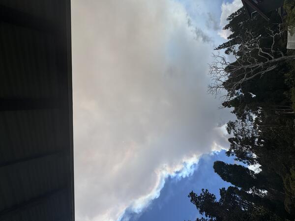
The dual fountains that erupted during Kīlauea summit eruption episode 43 on March 10, 2026, produced significant heat and ash, creating an eruption plume. The plume reached 10,000 feet (3050 meters) above sea level at 10:10 a.m. HST, over 20,000 feet (6100 meters) by 11:30 a.m. HST, and over 25,000 feet (7600 meters) above sea level by 10:50 a.m. HST. The maximum plume height exceeded 30,000 feet (9100 meters) above sea level by 11:30 a.m. HST. Light southwest winds at lower elevations pushed the plume and tephra fall to the north and east. This photograph, which looks toward the summit of Kīlauea, shows the plume traveling overhead. USGS photo.
Sources/Usage: Public Domain. View Media Details
Media
Tephra fallout from Kīlauea episode 43 lava fountaining accumulated on a water tank cover in Volcano Village, photographed on March 11, 2026. USGS photo.
Sources/Usage: Public Domain. View Media Details
Media
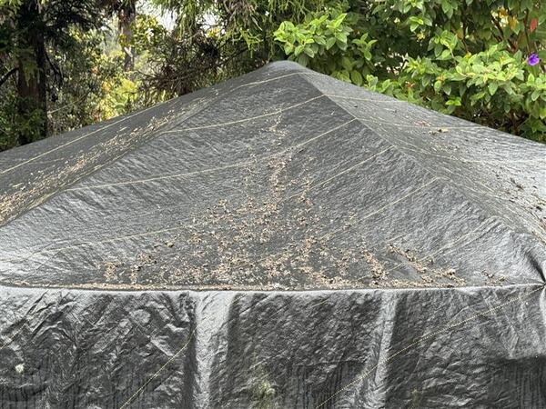
Tephra fallout from episode 43 lava fountaining at the summit of Kīlauea accumulated on a roof in Mauna Loa Estates, east of the eruptive vents. Fallout in this area was less severe than what occurred during episode 41, and included particles up to 3 inches in diameter but coverage was not continuous. USGS photo.
Sources/Usage: Public Domain. View Media Details
Media
Sources/Usage: Public Domain. View Media Details
Media
Ash fallout from Kīlauea summit lava fountaining episode 43 in Hilo just before 3 p.m. HST on March 10, 2026. USGS photo.
Sources/Usage: Public Domain. View Media Details
Media
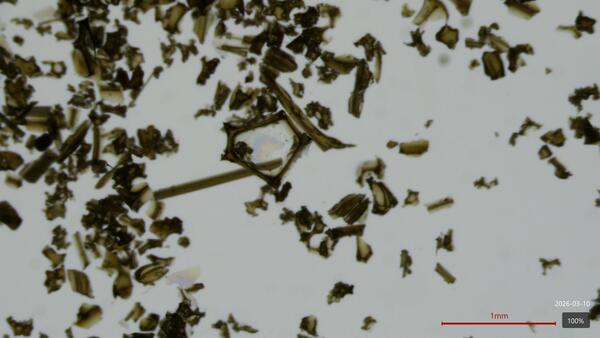
Microscopic images of Pele's hair and ash deposited in Hilo during Kīlauea's episode 43 fountains on March 10, 2026. The area in the center shows a bubble wall that was cooled and preserved. UHH/USGS photo by L. Gallant.
Sources/Usage: Public Domain. View Media Details