
By Hawaiian Volcano Observatory
March 14, 2025
USGS Hawaiian Volcano Observatory scientists captured aerial photography during a helicopter overflight on March 14 to map tephra deposits and other changes of the ongoing Halemaʻumaʻu eruption of Kīlauea within Hawaiʻi Volcanoes National Park.
Media
Sources/Usage: Public Domain. View Media Details
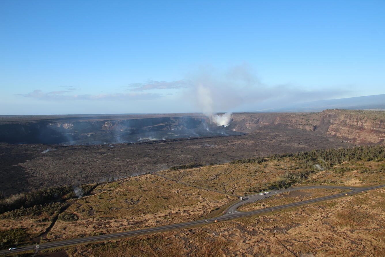
Media

A wide aerial view of the summit caldera (Kaluapele) at Kīlauea volcano, showing recent lava flows (center of photo) filling the deepest portion of Halema‘uma‘u crater. The white outgassing plume from the recently active vents is carried to the southwest in the tradewinds. The lower slopes of Mauna Loa's Southwest Rift Zone are visible in the background (center right). USGS photo taken by M. Patrick on March 14, 2025.
Sources/Usage: Public Domain. View Media Details
Media

A closer view of Halema‘uma‘u and the downdropped block, within the deepest portion of Kīlauea's summit caldera. Lava flows have crept eastward (towards bottom left in photo) as the crater floor rises with recent infilling. USGS photo taken on March 14, 2025, by M. Patrick.
Sources/Usage: Public Domain. View Media Details
Media

A low-angle aerial view of the vents where episodic fountaining has been occurring since the start of the ongoing Kīlauea summit eruption on December 23, 2024. A white plume of volcanic gas rises from the north vent (center right) and south vent (center left) cones in the southwest corner of Halema‘uma‘u crater, as viewed during a monitoring overflight. A discontinuous portion of road is visible in the lower left, which is a section of Crater Rim Drive that collapsed during 2018. The southeast flank of Mauna Loa is visible in the background. USGS photo by N. Deligne.
Sources/Usage: Public Domain. View Media Details
Media

On the morning of March 14, USGS Hawaiian Volcano Observatory scientists conducted an overflight of Kīlauea summit to capture thermal and surficial imagery of the ongoing (paused) eruption. Three days after the end of episode 13, this telephoto aerial view shows the north cone degassing in the southwest corner of Halema‘uma‘u. Gas from south vent comprises most of the upper center of the photo, obscuring south cone. USGS photo by N. Deligne.
Sources/Usage: Public Domain. View Media Details
Media

Sources/Usage: Public Domain. View Media Details
Media

This low-level aerial view of the tephra deposit from Kīlauea's ongoing summit eruption was captured during a Hawaiian Volcano Observatory helicopter overflight on Friday, March 14. Looking south over the area downwind of the eruptive vents within Halema‘uma‘u (itself out of view to the left), the closed portion of Crater Rim Drive southwest of the crater is seen blanketed in tephra from recent lava fountains. Fresh tire tracks in the tephra, since the episode 13 eruption concluded, were formed by geologists who access this area for sample collection and other important volcano monitoring activities that support hazard assessment. USGS photo taken by M. Zoeller.
Sources/Usage: Public Domain. View Media Details
Media

On Friday, March 14, Hawaiian Volcano Observatory geologists on a morning helicopter overflight captured aerial photography to map tephra deposits downwind (southwest) of vents from the Kīlauea summit eruption that began December 23, 2024. This oblique view to the north provides an overview of the tephra deposit, visible as a darker brown streak running across the terrain from right to left (near center of image), spanning about 1 mile (1.6 kilometers) in this view. Part of the closed portion of Crater Rim Drive in Hawai‘i Volcanoes National Park is visible near the right edge of the frame, with Halema‘uma‘u crater just out of view to the upper right. Although eruptive activity is currently paused, a plume of volcanic gas emissions (concentrated in the upper right) continues from the vents. USGS photo by M. Zoeller.
Sources/Usage: Public Domain. View Media Details
Media

An aerial view of the December 31, 1974 fissures and lava flows taken during an overflight of Kīlauea summit and upper Southwest Rift Zone on March 14, 2025. The 1974 eruption lasted 6 hours and occurred in Kīlauea's upper Southwest Rift Zone. More information about this eruption is available here: https://www.usgs.gov/observatories/hvo/news/volcano-watch-new-years-eve-1974-kilauea-volcanos-most-recent-southwest-rift. USGS photo by N. Deligne.
Sources/Usage: Public Domain. View Media Details