
Photo & Video Chronology — March 31, 2026 — Kīlauea summit monitoring overflight
By Hawaiian Volcano Observatory
March 31, 2026
USGS Hawaiian Volcano Observatory scientists completed a helicopter overflight of the Kīlauea summit on March 31, 2026, during which they captured photos of the eruptive vents in Halemaʻumaʻu, along with the tephra deposit from the ongoing episodic lava fountaining eruption.
Media
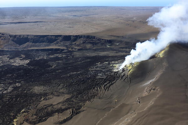
USGS Hawaiian Volcano Observatory scientists completed a helicopter overflight of the Kīlauea summit on March 31, 2026, during which they captured this overview photo of the eruptive vents in western Halema‘uma‘u crater. Both the north and south vents were vigorously degassing at the time, and a low pass over the two revealed a weakly spattering lava pond about 30 meters (100 feet) down in the south vent. USGS photo by M. Zoeller.
Sources/Usage: Public Domain. View Media Details
Media
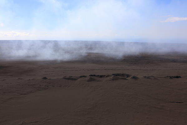
The tephra deposit from the ongoing Kīlauea summit eruption has dramatically changed the landscape in the predominant downwind direction (southwest) of Halema‘uma‘u crater. In this photo captured during the USGS Hawaiian Volcano Observatory helicopter overflight on March 31, a 200–400-year-old spatter cone complex known as Cone Peak is seen blanketed in recent tephra fall with only a few jagged rocks peeking out. For scale, this complex spans about 650 meters (2,100 feet) from end to end in this view. USGS photo by M. Zoeller.
Sources/Usage: Public Domain. View Media Details
Media
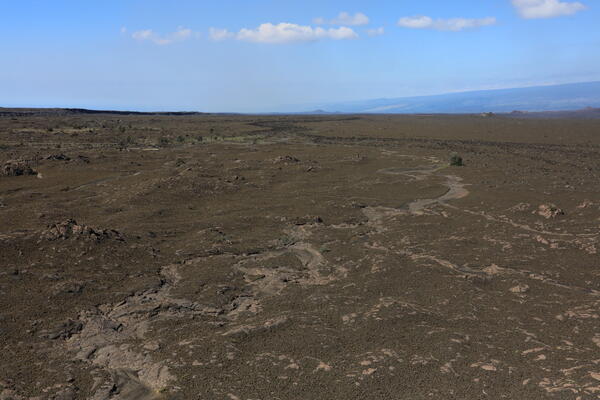
Despite the expansive nature of the tephra deposit from the ongoing Kīlauea summit eruption, recent rains from Kona low storms have taken their toll. In this photo captured during the USGS Hawaiian Volcano Observatory helicopter overflight on March 31, an ephemeral stream has eroded through the deposit to expose the much older lava flows underneath. This view is downslope to the southwest, with the KAMAKAIA Hills visible in the far distance near the center of the frame. USGS photo by M. Zoeller.
Sources/Usage: Public Domain. View Media Details
Media
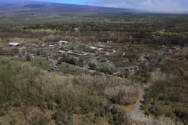
Around Hawai‘i Volcanoes National Park, cleanup efforts continue following the tephra fall that occurred during Kīlauea summit eruption episode 43 on March 10. A USGS Hawaiian Volcano Observatory scientist captured this overview photo of the Kīlauea Military Camp during the helicopter overflight on March 31, showing tephra still on many of the camp buildings' roofs. Browning foliage in the area is a result of volcanic gases blowing this direction during recent periods of Kona winds. USGS photo by M. Zoeller.
Sources/Usage: Public Domain. View Media Details