
Photo & Video Chronology — May 14, 2026 — Kīlauea episode 47
By Hawaiian Volcano Observatory
May 15, 2026
Episode 47 of the ongoing Halemaʻumaʻu eruption at the summit of Kīlauea lasted for 9 hours, from 3:27 p.m. HST on May 14, 2026, until 12:27 a.m. HST on May 15, 2026. Lava fountained from the north vent; sparse tephra fell in Hawaiʻi Volcanoes National Park. Fine ash and Peleʻs hair fell outside Hawaiʻi Volcanoes National Park in communities to the northeast.
Media
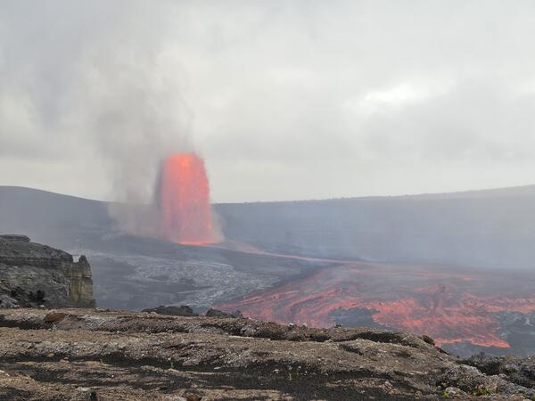
Episode 47 lava fountaining at Kīlauea summit began at approximately 3:27 p.m. HST Thursday, May 14, and continued for about 9 hours. Only the north vent produced high fountains with only sporadic spattering activity from the south vent. This photo taken around 5 p.m. from Uēkahuna overlook in Hawai‘i Volcanoes National Park shows how wide the fountain was in the early stages after the onset of the fountaining episode. USGS photo by M. Cappos.
Sources/Usage: Public Domain. View Media Details
Media
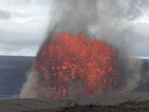
During episode 47 of the Kīlauea summit eruption that took place for 9 hours on Thursday May 14, the north vent fountains reached maximum heights of under 300 meters or 1,000 feet. In this photograph, taken from Uēkahuna overlook in Hawaiʻi Volcanoes National Park, a tephra whirlwind, or puahiohio, is visible just off to the right of the large tephra hill that has been forming since the start of these high fountaining events. USGS photo by M. Cappos.
Sources/Usage: Public Domain. View Media Details
Media
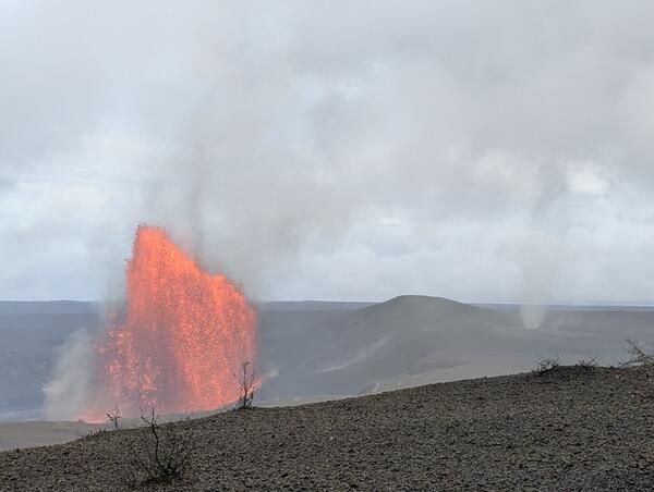
The north vent (right in photo) in Halemaʻumaʻu erupted a lava fountain during episode 47 at the summit of Kīlauea on May 14, 2026. It reached a maximum height of around 650 feet (200 meters). The south vent (left in photo) had intermittent spattering during the first two hours of the episode. USGS photo by L. Forster.
Sources/Usage: Public Domain. View Media Details
Media
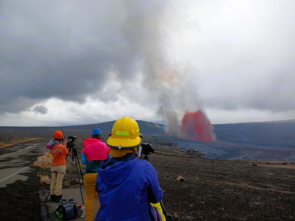
USGS Hawaiian Volcano Observatory geologists monitor lava fountaining in Halemaʻumaʻu at the summit of Kīlauea during episode 47 on May 14. 2026. From various locations around Kaluapele, Kīlauea summit caldera, USGS scientists check for tephra fallout, document and characterize eruptive activity, and measure the lava fountain and volcanic plume heights. USGS photo by R. Adams.
Sources/Usage: Public Domain. View Media Details
Media
Misty weather partially obscured views of episode 47 at the summit of Kīlauea on May 14, 2026. This photo was taken approximately 2 1/2 hours into the eruptive episode, which began at 3:27 p.m. HST. Only the north vent erupted a lava fountain, which fed channelized lava flows across the crater floor within Kaluapele. USGS photo by L. Forster.
Sources/Usage: Public Domain. View Media Details
Media
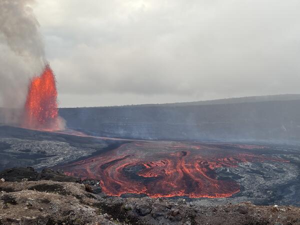
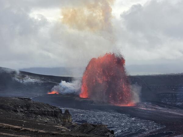
Episode 47 of lava fountaining in Halemaʻumaʻu began at the summit of Kīlauea at 3:27 p.m. HST on May 14th, 2026. This photo was taken nearly three hours later, at 6:18 p.m., from the south rim of the crater, and shows the north vent lava fountain (left) feeding lava flows that are advancing across the crater floor. USGS photo by N. Deligne.
Sources/Usage: Public Domain. View Media Details
Media
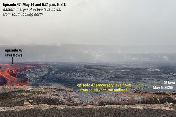
This annotated photo was taken at 6:24 p.m. HST on May 14, 2026, from the south rim of Halema‘uma‘u crater and looks north during episode 47 of lava fountaining at the summit of Kīlauea on May 14, 2026. Only north vent produced a lava fountain, and associated lava flows traversed east across the crater floor. However, about three hours into the episode, active lava flows were yet to reach the extent of cooled lava from south vent overflows that occurred in the lead up to episode 47 (labelled in yellow), which themselves had in part flowed over cooled lava from episode 46 (labelled in white). By the time the episode 47 ended, its lava flows covered an estimated 30–40% of the crater floor. USGS photo by N. Deligne.
Sources/Usage: Public Domain. View Media Details
Media
Episode 47 of the ongoing eruption at Halema‘uma‘u started at on May 14 at 3:27 p.m. HST and lasted 9 hours. This photo was taken shortly after sunset at 6:55 p.m. HST. The incandescent north vent lava fountain and its associated lava flows are seen through the vegetation at Kīlauea's summit region. USGS photo by L. Forster.
Sources/Usage: Public Domain. View Media Details
Media
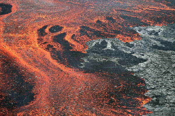
A close-up view of lava on the floor of Halemaʻumaʻu crater and the southwest side of Kaluapele, Kīlauea's summit caldera, during episode 47 on May 14, 2026. These flows remain hot and may slowly move in the days immediately following an eruptive episode. USGS photo by L. Gallant.
Sources/Usage: Public Domain. View Media Details
Media
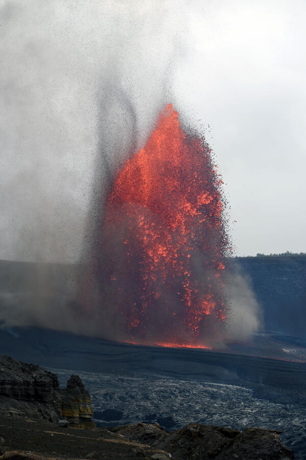
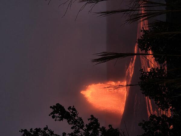
The lava fountain erupting from the north vent during episode 47 on May 14, 2026, seen here, sent light tephra into public areas of Hawai‘i Volcanoes National Park and surrounding communities to the northeast. Tephra is a general term for any fragmental material ejected during a volcanic eruption. USGS photo by L. Gallant.
Sources/Usage: Public Domain. View Media Details