
Volcanism on the other side of the world from the Yellowstone Caldera
The location on the other side of the world from the Yellowstone Caldera is in the southern Indian Ocean—a site near the Kerguelen Plateau, which formed about 130 million years ago and still hosts a few very remote and active volcanoes.
Yellowstone Caldera Chronicles is a weekly column written by scientists and collaborators of the Yellowstone Volcano Observatory. This week's contribution is from Shaul Hurwitz, research hydrologist with the U.S. Geological Survey.
In his 1864 science fiction novel Journey to the Center of the Earth, the French author Jules Verne tells a tale of Professor Otto Lidenbrock, the professor’s nephew, and their guide descending into the Icelandic volcano Snæfellsjökull to discover what is inside the Earth before they finally emerge back on Earth’s surface at Stromboli volcano in Italy. Now, try dreaming that instead of descending into an Icelandic volcano and exiting in Italy, you descend into the Yellowstone Caldera and then travel to the center of the Earth through the mantle and core, where the temperatures are 5,000 °C to 6,000 °C (9,000 °F to 10,800 °F). To return to Earth’s surface, you exit at the exact opposite side of the world from Yellowstone. Where would that be?
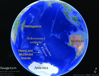
The point on Earth’s surface that lies directly opposite another location is called an antipode. Not all antipodes on Earth have the exact same length because the shape of the Earth is not a perfect sphere. Earth is slightly flattened at the poles due to its rotation, so the radius at the equator is 6,378 kilometers (3,963 miles), and slightly less at the poles, 6,357 kilometers (3,950 miles). Earth's average radius is approximately 6,371 kilometers (3,959 miles), so the average length of an antipode (twice the radius) is 12,742 kilometers (7,918 miles).
The antipode of Yellowstone Caldera is in the southern Indian Ocean, just to the north of the Kerguelen Plateau. This plateau is a large, mostly submerged volcanic and magmatic province that was created about 130 million years ago. The plateau formed due to the Kerguelen hotspot following the breakup of the Gondwana supercontinent. The Kerguelen Plateau extends for more than 2,200 kilometers (1,400 miles) in a northwest-southeast direction and covers an area of about 1.2 million square kilometers (471,000 square miles), which is almost three times the size of California. A small portion of the plateau is above sea level, forming the remote Kerguelen Islands (a French territory), where during the winter less than 50 people live, and the Heard and McDonald Islands (an Australian territory), which are UNESCO World Heritage sites.
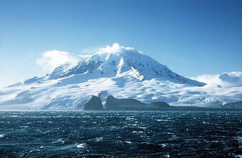
There are few active volcanoes in the Kerguelen Plateau that are driven by the still active Kerguelen hotspot. Visual observations of eruptions at these volcanoes are very rare due to their remote location. Some eruptions in the past few decades were only documented by satellite observations, and there are probably others that have remained undocumented. Heard Island, approximately 1,700 kilometers (1,056 miles) north of the Antarctic continent, consists primarily of the emergent portion of two volcanic structures. The large glacier-covered cone of Big Ben volcano comprises most of the island, and the smaller Mt. Dixon lies at the NW tip of the island. Little is known about the structure of Big Ben because of its extensive ice cover, which is shrinking rapidly, but several subglacial eruptions have been reported. Big Ben last erupted on February 11, 2026, and based on satellite observations produced an ash plume rising to 7.3 kilometers (24,000 feet). The active Mawson Peak forms the island's highest point and lies within a 5-6 kilometer-wide caldera breached to the southwest side of Big Ben.
The McDonald Islands are about 75 kilometers (47 miles) to the west of Heard Island. The largest, McDonald Island, is only one square kilometer (0.4 square miles) in area and about 200 meters (650 feet) high. Volcanic plumes were observed in December 1996 and January 1997 from the Island. In March 1997 the crew of a vessel that sailed near the island noted vigorous steaming from a vent on the north side of the island along with possible pyroclastic and lava flow deposits. A satellite image from 2001 showed the island to have more than doubled in area since previous reported observations a year earlier.
Using an online antipode calculator and searching the Smithsonian Institution’s Global Volcanism Program database, you can find the antipode location of where you live and for active volcanoes nearby. For the continental United States and Alaska, the antipode location will be somewhere in the Indian Ocean. The antipode location of the most active volcano in the Indian Ocean, Piton de la Fournaise on the island of La Réunion is in the Pacific Ocean, about 1,500 kilometers (932 miles) southwest of Cabo San Lucas in Baja California, Mexico. But, if like Professor Otto Lidenbrock and his team you dream of descending into an active volcano and descend into Kīlauea in Hawaiʻi, and resurface at the antipode location, you will end up in Botswana, a country in Africa with no active volcanoes. Enjoy the wild dream!