



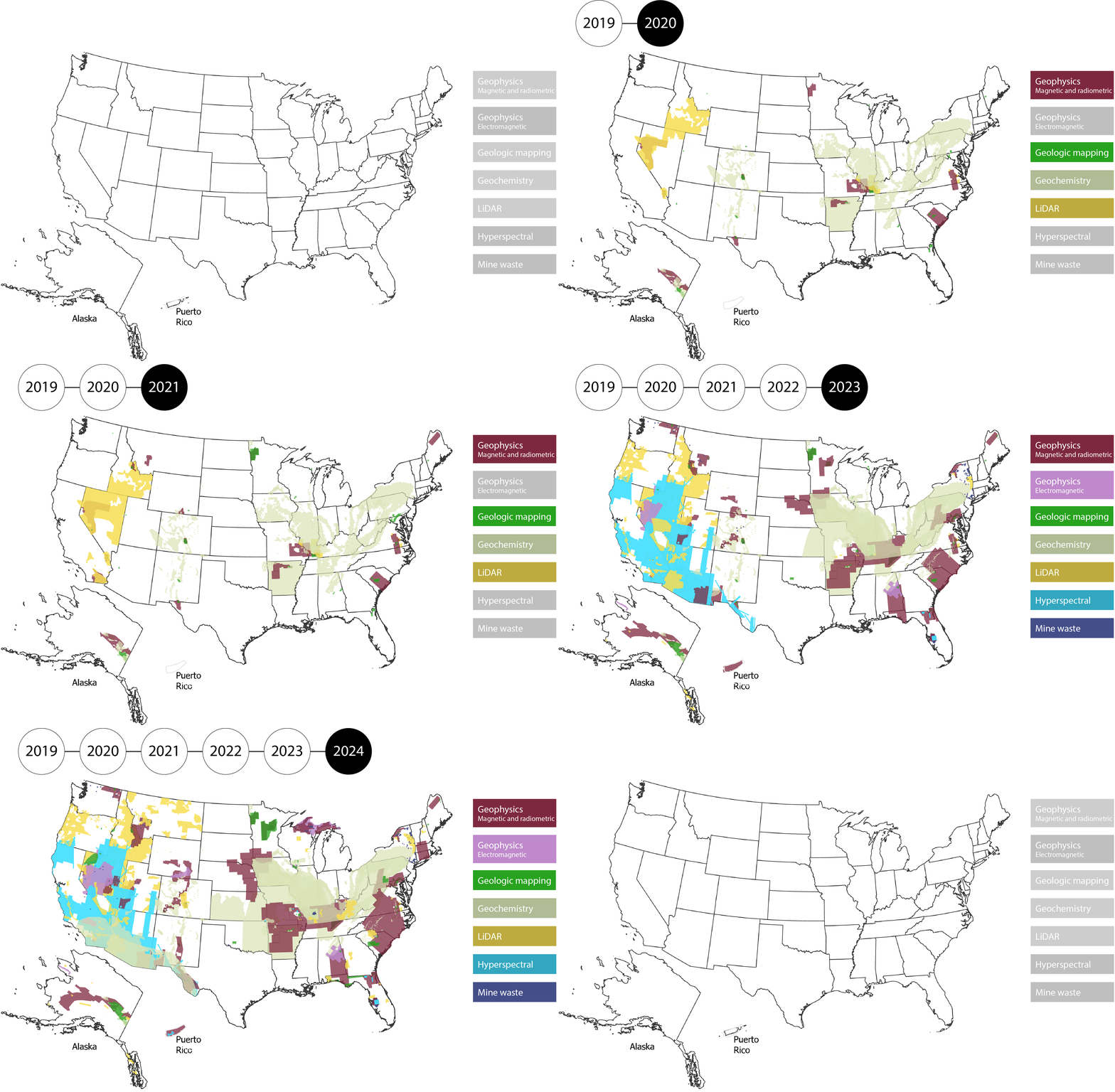
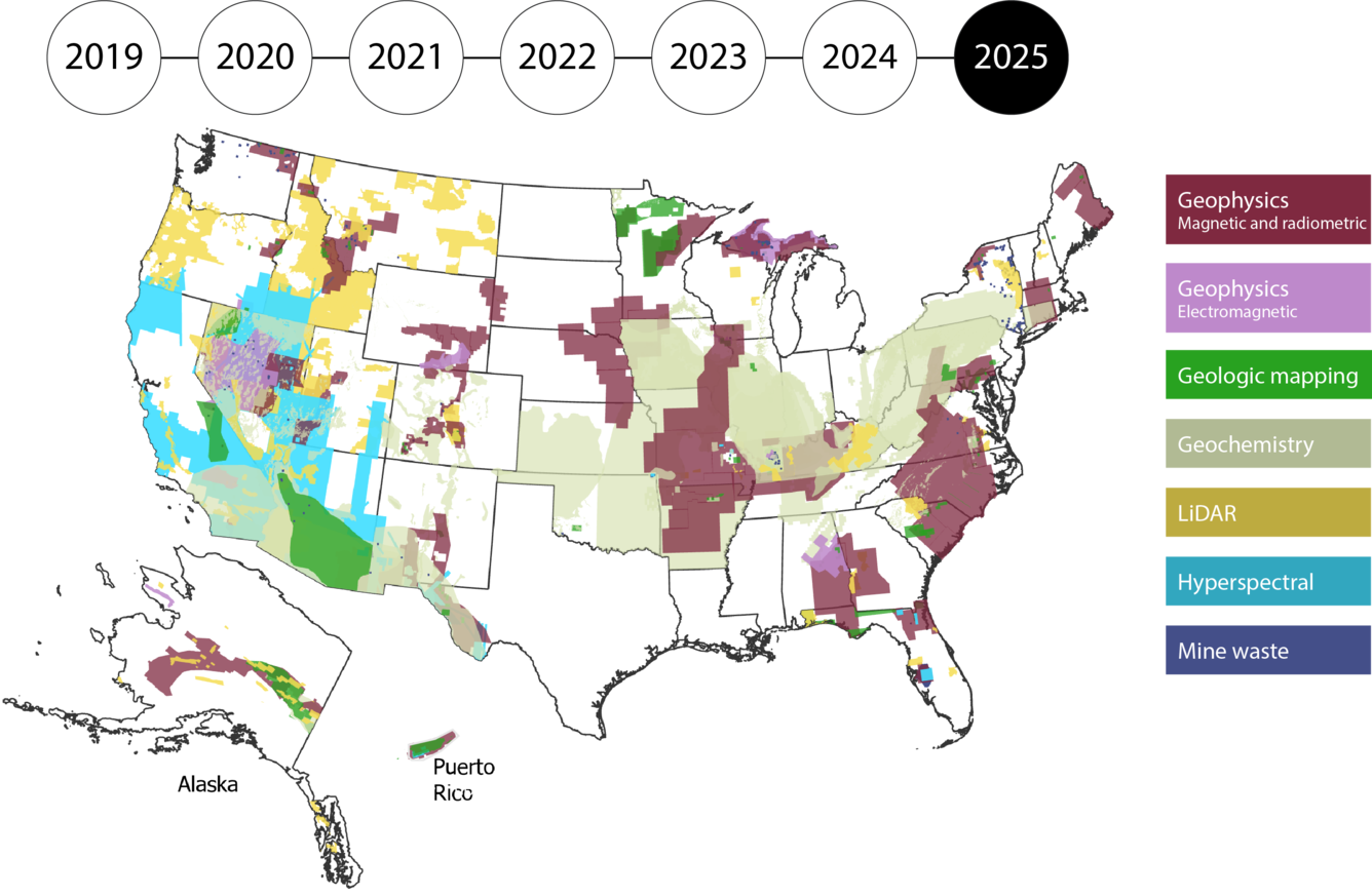
The U.S. needs high-quality geologic data to identify critical and other mineral resources, energy resources, make important land use decisions, and identify natural disasters. Since 2019, Earth MRI has advanced modern mapping of the US through the collection of geophysical, geochemical, geologic, topographic, hyperspectral, mine waste and other data, focusing on areas with the potential for critical minerals.
Take a tour through Earth MRI's progress and accomplishments...
FY 2019
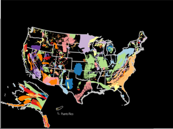
The USGS Mineral Resources Program launches Earth MRI!
Earth MRI, in partnership with State geological surveys, builds on the Program’s previous research to develop a national map of areas with critical mineral potential. This “Mineral Systems Map” is used to guide data collection and represents a new approach to identifying areas with potential mineral resources, based on regional geological characteristics. Over the next two years, Earth MRI will delineate more than 800 focus areas with potential mineral resources.
Earth MRI also begins funding the collection of geologic, geochemical and geophysical data, initially focusing on areas that might contain rare earth elements.
Prior to Earth MRI, only 7% of the U.S. was covered by high-quality magnetic-radiometric data: in this first year, Earth MRI increases magnetic-radiometric data coverage to 8%.
By the Numbers
FY 2020
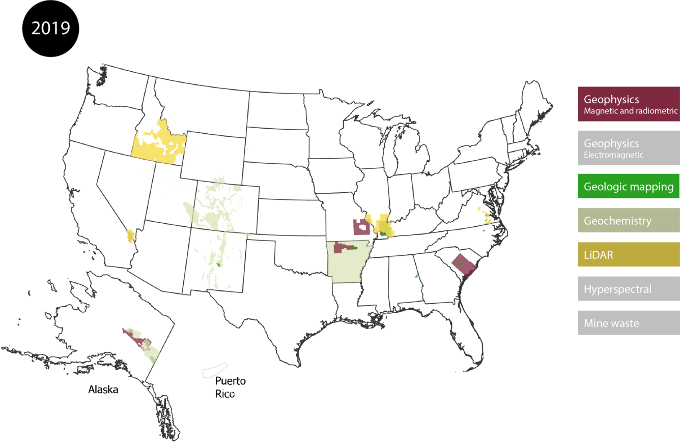
Earth MRI collects its first geophysical data (magnetic-radiometric data funded in 2019), with initial surveys in California’s Mountain Pass, the Hicks Dome area in Illinois and Kentucky and the Yukon-Tanana upland in the eastern part of Alaska’s interior.
In the same year, the Energy Act of 2020 is passed. In response to the Act, the USGS begins efforts to conduct nation-scale assessments of critical minerals. Earth MRI data become a foundational piece of USGS’ efforts to meet Congressional direction to map the Nation’s undiscovered critical mineral resources.
Earth MRI also significantly expands its partnerships, collecting data in a dozen new states, as well as partnering with the Department of Energy to collect magnetic-radiometric and LiDAR data in western Nevada focused on shedding light on the region’s lithium and other critical mineral, geothermal energy and groundwater resources, and natural hazards.
By the Numbers
FY 2021
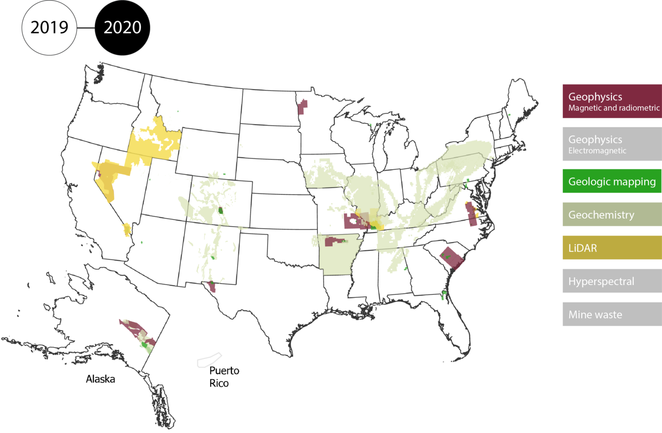
The Infrastructure Investment and Jobs Act (IIJA) invests \$320 million in Earth MRI over five years, significantly increasing the capability of the initiative to collect data across the Nation.
In the same year, Earth MRI increases magnetic-radiometric data coverage to 10% and collects data over another 6 states, focusing on areas with the potential for critical mineral resources both above- and below ground (such as in mine wastes and geologic deposits).
Earth MRI begins an additional partnership with the Department of Energy to collect magnetic-radiometric data over the Salton Trough of California to help identify potential geothermal and mineral resources.
By the Numbers
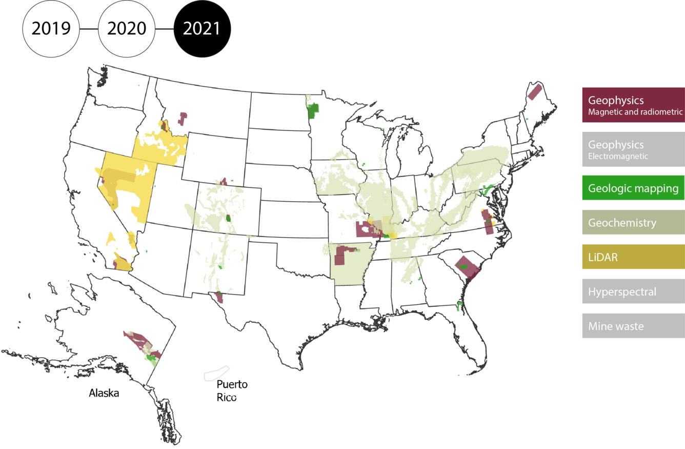
FY 2022
Earth MRI data collection ramps up. With IIJA funding, Earth MRI adds a new kind of geophysical survey to its suite of data collection: electromagnetic surveys. The first electromagnetic survey is conducted on the Seward peninsula in Alaska to better understand potential graphite resources in the area.
Earth MRI also begins working with three states to develop a national mine waste sampling program and protocol. Mine wastes – the material left behind by mining activities – could be a source of valuable minerals.
In partnership with NASA, Earth MRI starts collecting high-quality hyperspectral data across the American southwest.
By the Numbers
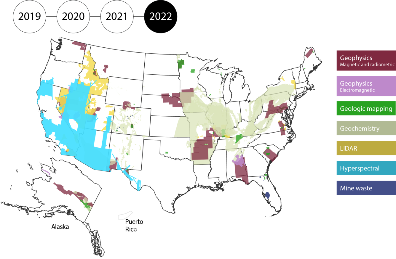
FY 2023
Earth MRI data collection continues to gain momentum, including increasing magnetic-radiometric data coverage to 19% and covering a third of the initial focus areas identified.
Earth MRI also expands mine waste data collection by launching a new annual competitive program to partner with State geological surveys to inventory and characterize mine wastes.
Following the destruction of hurricanes Fiona and Ian, Earth MRI collects data in Florida and Puerto Rico to support hurricane and other hazard resilience and reconstruction.
By the Numbers
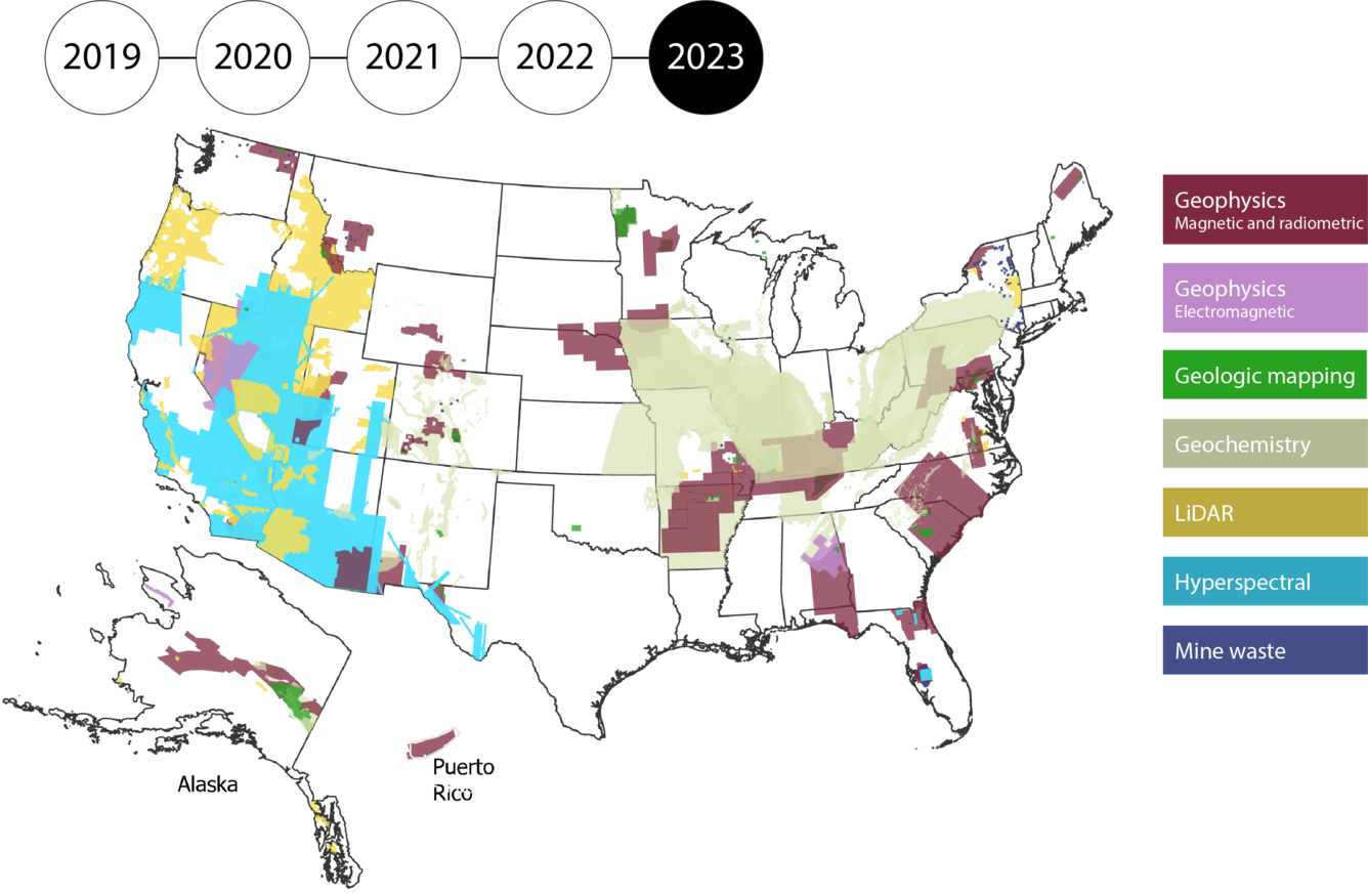
FY 2024
Earth MRI continues to strengthen partnerships with local communities and Tribes, facilitating new data collection in the mid-continent and Great Lakes Region.
Earth MRI completes, in partnership with NASA, the largest high-quality hyperspectral survey of its kind in the world, delivering data that will be used to better address questions in the southwest from mineral and energy resource availability to land cover change, and wildfire risk.
Earth MRI also invests a record amount in mine waste research, bringing the cumulative number of states involved in Earth MRI mine waste research to 21. This data is directly contributing to the development of an authoritative National Mine Waste Inventory.
By the Numbers
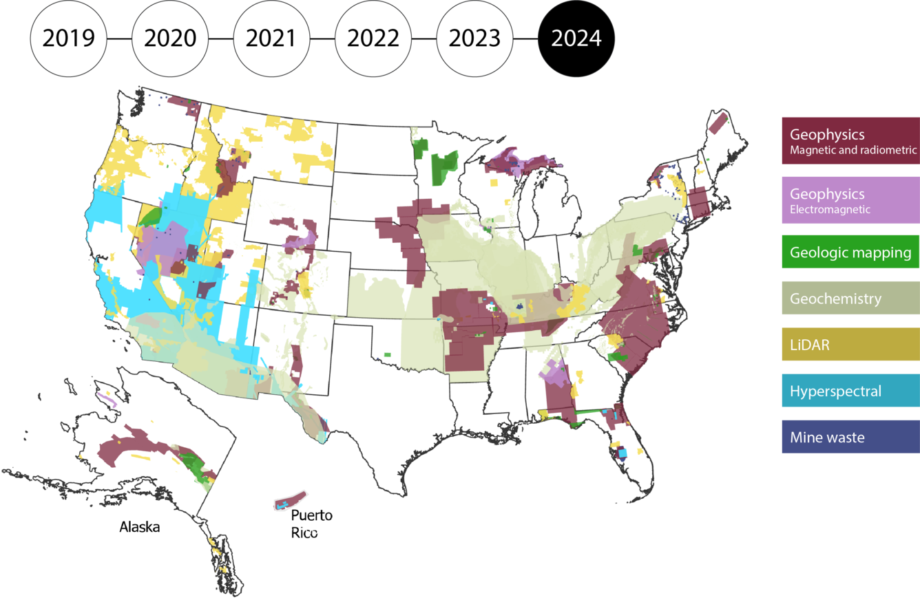
FY 2025
Earth MRI makes big strides towards a fuller picture of mine wastes and their resources including:
Earth MRI publishes standard sampling protocols for mine waste that ensure comparable data from site site to site across the Nation.
The first Earth-MRI funded projects to characterize minerals in mine wastes are published by State geological survey partners in Colorado and New Mexico.
Earth MRI also collects hyperspectral data with a new sensor, increasing the resolution of spatial data by ~400% and spectral data by ~200%. This means each pixel of data is just 8-17 m., providing a far more detailed view of potential minerals on the Earth's surface.
By the Numbers
Into the Future
Earth MRI is continuing to collect data at an accelerated pace through FY 2026.
Future goals of Earth MRI include:
- Complete high-resolution magnetic-radiometric coverage of all critical mineral focus areas now known and any discovered through new Earth MRI data
- Inventory all significant legacy and active critical minerals-related mine waste sites in the United Sates to contribute to the National Mine Waste Inventory, and to evaluate mine waste volumes and potential critical mineral endowments
- Integrate and analyze new data to support national mineral resource assessments of critical minerals below the surface and in above-ground mine waste
- Continue to develop modern, innovative delivery systems for Earth MRI data, including accessible and intuitive web-based tools
The U.S. needs high-quality geologic data to identify critical and other mineral resources, energy resources, make important land use decisions, and identify natural disasters. Since 2019, Earth MRI has advanced modern mapping of the US through the collection of geophysical, geochemical, geologic, topographic, hyperspectral, mine waste and other data, focusing on areas with the potential for critical minerals.
Take a tour through Earth MRI's progress and accomplishments...
FY 2019
The USGS Mineral Resources Program launches Earth MRI!
Earth MRI, in partnership with State geological surveys, builds on the Program’s previous research to develop a national map of areas with critical mineral potential. This “Mineral Systems Map” is used to guide data collection and represents a new approach to identifying areas with potential mineral resources, based on regional geological characteristics. Over the next two years, Earth MRI will delineate more than 800 focus areas with potential mineral resources.
Earth MRI also begins funding the collection of geologic, geochemical and geophysical data, initially focusing on areas that might contain rare earth elements.
Prior to Earth MRI, only 7% of the U.S. was covered by high-quality magnetic-radiometric data: in this first year, Earth MRI increases magnetic-radiometric data coverage to 8%.
By the Numbers
FY 2020
Earth MRI collects its first geophysical data (magnetic-radiometric data funded in 2019), with initial surveys in California’s Mountain Pass, the Hicks Dome area in Illinois and Kentucky and the Yukon-Tanana upland in the eastern part of Alaska’s interior.
In the same year, the Energy Act of 2020 is passed. In response to the Act, the USGS begins efforts to conduct nation-scale assessments of critical minerals. Earth MRI data become a foundational piece of USGS’ efforts to meet Congressional direction to map the Nation’s undiscovered critical mineral resources.
Earth MRI also significantly expands its partnerships, collecting data in a dozen new states, as well as partnering with the Department of Energy to collect magnetic-radiometric and LiDAR data in western Nevada focused on shedding light on the region’s lithium and other critical mineral, geothermal energy and groundwater resources, and natural hazards.
By the Numbers
FY 2021
The Infrastructure Investment and Jobs Act (IIJA) invests \$320 million in Earth MRI over five years, significantly increasing the capability of the initiative to collect data across the Nation.
In the same year, Earth MRI increases magnetic-radiometric data coverage to 10% and collects data over another 6 states, focusing on areas with the potential for critical mineral resources both above- and below ground (such as in mine wastes and geologic deposits).
Earth MRI begins an additional partnership with the Department of Energy to collect magnetic-radiometric data over the Salton Trough of California to help identify potential geothermal and mineral resources.
By the Numbers
FY 2022
Earth MRI data collection ramps up. With IIJA funding, Earth MRI adds a new kind of geophysical survey to its suite of data collection: electromagnetic surveys. The first electromagnetic survey is conducted on the Seward peninsula in Alaska to better understand potential graphite resources in the area.
Earth MRI also begins working with three states to develop a national mine waste sampling program and protocol. Mine wastes – the material left behind by mining activities – could be a source of valuable minerals.
In partnership with NASA, Earth MRI starts collecting high-quality hyperspectral data across the American southwest.
By the Numbers
FY 2023
Earth MRI data collection continues to gain momentum, including increasing magnetic-radiometric data coverage to 19% and covering a third of the initial focus areas identified.
Earth MRI also expands mine waste data collection by launching a new annual competitive program to partner with State geological surveys to inventory and characterize mine wastes.
Following the destruction of hurricanes Fiona and Ian, Earth MRI collects data in Florida and Puerto Rico to support hurricane and other hazard resilience and reconstruction.
By the Numbers
FY 2024
Earth MRI continues to strengthen partnerships with local communities and Tribes, facilitating new data collection in the mid-continent and Great Lakes Region.
Earth MRI completes, in partnership with NASA, the largest high-quality hyperspectral survey of its kind in the world, delivering data that will be used to better address questions in the southwest from mineral and energy resource availability to land cover change, and wildfire risk.
Earth MRI also invests a record amount in mine waste research, bringing the cumulative number of states involved in Earth MRI mine waste research to 21. This data is directly contributing to the development of an authoritative National Mine Waste Inventory.
By the Numbers
FY 2025
Earth MRI makes big strides towards a fuller picture of mine wastes and their resources including:
Earth MRI publishes standard sampling protocols for mine waste that ensure comparable data from site site to site across the Nation.
The first Earth-MRI funded projects to characterize minerals in mine wastes are published by State geological survey partners in Colorado and New Mexico.
Earth MRI also collects hyperspectral data with a new sensor, increasing the resolution of spatial data by ~400% and spectral data by ~200%. This means each pixel of data is just 8-17 m., providing a far more detailed view of potential minerals on the Earth's surface.
By the Numbers
Into the Future
Earth MRI is continuing to collect data at an accelerated pace through FY 2026.
Future goals of Earth MRI include:
- Complete high-resolution magnetic-radiometric coverage of all critical mineral focus areas now known and any discovered through new Earth MRI data
- Inventory all significant legacy and active critical minerals-related mine waste sites in the United Sates to contribute to the National Mine Waste Inventory, and to evaluate mine waste volumes and potential critical mineral endowments
- Integrate and analyze new data to support national mineral resource assessments of critical minerals below the surface and in above-ground mine waste
- Continue to develop modern, innovative delivery systems for Earth MRI data, including accessible and intuitive web-based tools