
Humboldt Capture Query Tool
May 15, 2026
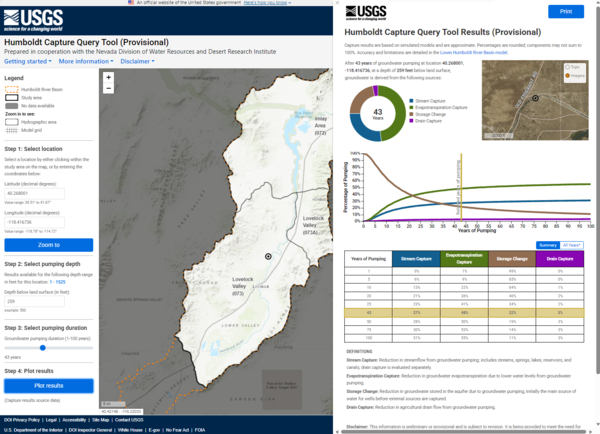
The Humboldt Capture Query Tool (HCQT) provides easy access to model-estimated capture and storage change data, supporting informed decisions about integrated water resource management. The HCQT displays 100 years of estimated groundwater pumping impacts, based on groundwater models for the upper, middle, and lower Humboldt River Basin.
Media
Sources/Usage: Public Domain. View Media Details
Key Features
- Comprehensive Capture Components
Explore sources of water for capture, such as:- Stream Capture – Reduction in streamflow caused by groundwater pumping.
- Groundwater Evapotranspiration Capture (ETg) – Reduction in groundwater evapotranspiration due to groundwater pumping.
- Storage Change – Changes in groundwater storage due to groundwater pumping, the first source of water to a well.
- Drain Capture – Reduced agricultural drain flow due to groundwater pumping in the lower Humboldt River Basin.
- Custom Plots
Generate estimated capture and storage change curves for selected pumping locations and depths. - Integrated Data
Access results from potential capture analyses for the Humboldt River Basin from the supporting model application and capture results data releases.
Groundwater pumping can significantly impact streamflow and other water resources. HCQT provides a clear, science-based way to visualize these interactions and support informed water management decisions across the Humboldt River Basin.
Related

Science in the Humboldt River Basin
The Humboldt River flows east to west through north-central Nevada and is about 330 miles long. It is an important water source for residents and agriculture, and it also supports one of Nevada’s largest industries—gold mining. Most of the state’s mines are in the Humboldt River Basin along the Carlin Trend. Nevada produces about 72 percent of all U.S. gold, making it the fifth largest producer in...

Evaluation of Streamflow Depletion Related to Groundwater Withdrawal, Humboldt River Basin
This project evaluates how groundwater withdrawals affect streamflow in the Humboldt River Basin. It focuses on understanding the timing, magnitude, and causes of streamflow depletion, including agricultural pumping and mine dewatering, to support sustainable water management in Nevada.
Related
Science in the Humboldt River Basin
The Humboldt River flows east to west through north-central Nevada and is about 330 miles long. It is an important water source for residents and agriculture, and it also supports one of Nevada’s largest industries—gold mining. Most of the state’s mines are in the Humboldt River Basin along the Carlin Trend. Nevada produces about 72 percent of all U.S. gold, making it the fifth largest producer in...
Evaluation of Streamflow Depletion Related to Groundwater Withdrawal, Humboldt River Basin
This project evaluates how groundwater withdrawals affect streamflow in the Humboldt River Basin. It focuses on understanding the timing, magnitude, and causes of streamflow depletion, including agricultural pumping and mine dewatering, to support sustainable water management in Nevada.