An official website of the United States government
Here's how you know
Official websites use .gov
A .gov website belongs to an official government organization in the United States.
Secure .gov websites use HTTPS
A lock () or https:// means you’ve safely connected to the .gov website. Share sensitive information only on official, secure websites.
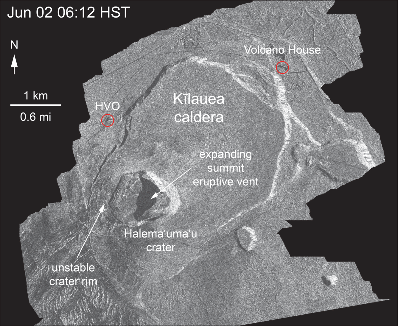
This animated GIF shows a sequence of radar amplitude images that were acquired by the Italian Space Agency's Cosmo-SkyMed satellite system. The images illustrate changes to the caldera area of Kīlauea Volcano that occurred between May 5 and June 6 at 6:00 a.m. HST. The satellite transmits a radar signal at the surface and measures the strength of the return, with bright areas indicating a strong return and dark areas a weak return. Strong returns indicate rough surfaces or slopes that point back at the radar, while weak returns come from smooth surfaces or slopes angled away from the radar. Over time, expansion of the summit eruptive vent within Halema‘uma‘u crater and the widening of Halema‘uma‘u itself are clear. The last three images in the sequence, from May 29-June 6, show the development of several cracks outside Halema‘uma‘u (also seen in UAS footage of the crater) and inward slumping of a large portion of the western and southwestern crater rim. The west side of Halema‘uma‘u is clearly unstable, and it is likely that rockfalls and continued slumping will occur in the future.
On June 6, at 4:07 p.m. HST, an explosion within Halema‘uma‘u sent an ash and gas plume to a height of about 10,000 feet above sea level. The explosion released energy equivalent to that of a magnitude-5.6 earthquake; a result of the explosion-related energy release was ground shaking felt throughout the summit area. This plume is typical of those produced by the larger explosions that have occurred at Kīlauea's summit.
Ground views of the former parking area near Halema‘uma‘u
Many large blocks appeared to be in depressions in the ash, but upon closer examination, it was concluded that wind had winnowed ash from around the blocks, creating a false impression that the depressions were made by impact. In places, ash has accumulated on the upwind sides and been removed from the downwind sides of the ballistics, giving a smooth streamlined appearance to the parking lot.
With careful consideration and planning to avoid ongoing volcanic hazards as much as possible, an HVO scientist who has been studying the behavior of Kīlauea's summit for decades, briefly visited the parking area for the former Halema‘uma‘u overlook (closed since 2008) on June 5 to make direct observations of and gather data from the effects of recent explosions within Halema‘uma‘u. Through these photos, we share with you what he saw and learned. The parking lot is strewn with small ballistic blocks. Most are only a few centimeters across, with the largest blocks around 45 cm (18 inches) in diameter.
The median between two areas of the parking lot has been warped and broken by cracks. Ash accumulation in the parking area was generally not more than 4 cm (1.5 in) thick.
The Halema‘uma‘u parking lot is sliced into blocks by cracks. These cracks, first noted in a very early stage on May 13, now are the dominant features of the parking lot. The cracks, which are circumferential to Halema‘uma‘u, warp and offset the pavement and curbing, as seen here. The crack responsible for warping this curbstone is visible on both sides of it.
Crack on Crater Rim Drive just east of the parking lot, with the National Park sign indicating "Halema‘uma‘u" at right. This crack shows 42 cm (16.5 in) of right lateral offset—as measured by fitting the center stripe on the road back together)—and was about 25 cm (10 in) wide.
Fissure 8 continues to produce fountains and channelized lava flows
View of the fissure 8 lava fountain and lava channel that travels to the ocean, a distance of about 12.5 km (7.8 mi). Photo taken during this morning's overflight at about 6:30 a.m. HST.
Lava entering the ocean in the vicinity of Kapoho Bay is forming a lava delta, as seen from the air during this morning's overflight at about 7:00 a.m. HST.
Lava enters the ocean in the vicinity of Vacationland at 7AM HST on June 7. The ocean entry produces a white plume called "laze," which drifts downwind. Laze is composed of steam, hydrochloric acid and tiny glass particles, which can irritate the lungs, eyes and skin.
Beginning on June 3, lava from fissure 8 entered the ocean at Kapoho Bay. By June 6, lava had completely filled Kapoho Bay and built a delta that now extends over a mile from shore. A helicopter overflight of Kīlauea Volcano's lower East Rift Zone on June 6, 2018, around 5:00 pm.m HST documented lava-seawater interactions at the ocean entry and the formation of a white plume called laze. Lava entering the ocean builds a platform of new land known as a lava delta. This new land appears stable, but hides a foundation of loose rubble that can collapse into the ocean.
Clear conditions at Pu‘u ‘Ō‘ō provided good views into the crater. The crater floor collapsed, and the lava lake drained, a little more than a month ago.The crater now has a funnel-shape geometry with a deeper cylindrical shaft. Rubble fills the base of the shaft.