



FY27 3DHP Data Collaboration Announcement (DCA)
The USGS 3D National Topography Model (3DNTM) integrates USGS elevation and hydrography datasets to model the Nation's topography in 3D. The 3D Hydrography Program (3DHP) is the hydrography component of the 3DNTM. This DCA will result in public domain 3DHP data for the 3DNTM obtained through collaboration between the USGS and a broad range of partners. SAM.gov (Reference #DOIDSAM27G002)
3DHP Application Instructions | 3DHP Project Evaluation Considerations | 3DHP Important Information | 3DHP Application Materials
3DHP Application Instructions
IMPORTANT: Project submissions for 3DHP will be reviewed after the submission deadline but project selection may not be finalized until the fiscal year 2027 (FY27) federal budget is passed.
- Project Submission Dates and Times
- Project submission emails to 3dhp_dca@usgs.gov must be received by 5:00 PM ET on Friday December 4, 2026.
- Project submissions received after the deadline will be considered for review after initial project selections are made.
- Project submissions will be considered for review until no remaining FY27 funds are available for obligation.
- Eligible Applicants
- Single entities or groups of federal agencies, state and local governments, tribes, academic institutions, and the private sector are eligible to submit projects.
- Geospatial Products and Services Contracts (GPSC) contractors and subcontractors are excluded from applying to the 3DNTM DCA.
- To submit a 3DHP project for consideration, email the required documents and forms to 3dhp_dca@usgs.gov. The email subject line should include the following: State, Last name of the primary applicant, FY27DCA – 3DHP (e.g. VASmithFY27DCA – 3DHP). It is very important that the email indicates which 3DNTM component program is being applied for (i.e. 3DEP or 3DHP).
- Required forms and files to submit:
- 3DHP-A - DCA Project Summary Form
- 3DHP-D - Validation of Proposed Funding Partners. A separate form for each funding partner should be included.
- A vector geographic information system (GIS) file defining the location and coverage area of the project. The file should be formatted as described in 3DHP-B - Instructions for Creating 3DHP Project Boundaries.
- All required forms and instructions are available for download here
- Withdrawal of a Project Submission
- Project submissions may be withdrawn by emailing a request to 3dhp_dca@usgs.gov. Withdrawals are effective upon acknowledgement of the request by the 3DHP Data Acquisition Lead.
- Notice of Project Acceptance
- Timing of project acceptance notification emails depends on the FY27 federal budget.
- Staggered notification of project selections is likely as selections are dependent upon the availability of federal funds.
- Applicants whose projects are accepted for funding will be contacted by a Program and/or GPSC representative to continue project development, determine the final funding amount from both the applicant and USGS, and establish the period of performance for the GPSC Task Order.
- FAQ are available on the DCA Portal. Please email additional questions about the DCA or project submission process to 3dhp_dca@usgs.gov. Questions received may be added to the FAQ after removing identifying information.
- Past project selections can be found on the DCA Portal.
3DHP expects to select multiple projects through the FY27 DCA. Each project submission will be reviewed individually, on its own merits, to confirm that it meets with program goals and represents good value to the Government. The evaluation considerations are intended to highlight the importance of fostering engagement and identifying mutual areas of interest and common goals between the federal, state, and local 3DNTM partners. Details are provided below.
- Project Location
- 3DHP seeks nationwide coverage and welcomes project submissions from across the United States, except Alaska, where hydrographic features and watershed boundaries are being derived from Alaska IfSAR 3DEP elevation data through existing partnerships.
- Consideration will be given for project areas:
- With published 3DEP data, as shown on the USGS Lidar Explorer Map, and with no existing or in-progress 3DHP data as defined on 3DHP-F - FY27 Consolidated Federal Priority Acquisition Areas.
- Project submissions may be considered on a limited basis over areas where 3DEP data have been acquired but are not yet published.
- Federal agencies have provided priorities in accordance with their current goals and objectives for hydrography data. Consideration is given to projects that overlap priority areas identified in 3DHP-F - FY27 Consolidated Federal Priority Acquisition Areas.
- Project Cost, Cost Realism, and Cost Share (funds contributed by applicant)
- The cost of hydrography data acquisition varies based on the geographic extent of the project, terrain, land cover, and land use characteristics. Applicants must include an ESTIMATED cost of their project using any of the following methods:
- A project planning estimate (PPE) received from the USGS GPSC Commercial Partnership Team. Applicants should follow the instructions and submit 3DHP-C - Request for Planning Project Estimate as soon as possible and no later than by 5:00 PM ET on Friday November 13, 2026 to receive the estimate in time to meet the December 4, 2026 project submission deadline.
- An estimate received from a hydrography data acquisition contractor.
- An estimate from another source along with an explanation of how the cost estimate was derived.
- For estimates not based on a USGS PPE, the USGS will complete an independent review during the evaluation period to determine if the estimates reflect valid industry cost for the specific geographic area and reflect a good value to the Government.
- Consideration is given to applicants that offer larger contributions (cost share) to the total cost of their project.
- The USGS cost share for eligible projects is subject to availability of funds and applicable statutes (43 USC 50).
- The cost of hydrography data acquisition varies based on the geographic extent of the project, terrain, land cover, and land use characteristics. Applicants must include an ESTIMATED cost of their project using any of the following methods:
- Maturity of Applicant’s Project Submission and Maturity of Designated Funding Sources
- Applicants are required to provide verification of all proposed funding partners listed in their project submission via 3DHP-D -Validation of Proposed Funding Partners.
- A “mature” project submission will have a large proportion of guaranteed funding.
- Consideration will be given to applicants who engage in multi-state or federal funding coalitions where project areas cross state boundaries.
- Past Performance
- Past performance is evaluated based on the applicant’s history of financial management and partnering through the GPSC, if available.
3DHP Important Information
- Data Acquisition Approach
- Applicants may request data acquisition through the USGS Geospatial Products and Services Contracts (GPSC), which is currently the sole mechanism available for obtaining data through the DCA.
- The GPSC is a multiple award acquisition vehicle that is designed to utilize the teams of firms on the contract for services needed to accomplish 3DEP and 3DHP data acquisition.
- The GPSC is also available for use by organizations to acquire geospatial data outside of the 3DNTM DCA.
- The USGS will not accept joint 3DEP-3DHP applications or applications for simultaneous data acquisition of 3DEP and 3DHP.
- 3DHP Data Acquisition in Alaska
- No DCA submissions for 3DHP data acquisition in Alaska will be accepted in FY27 because hydrographic features are being derived from the 3DEP 5-meter Alaska IfSAR elevation data through existing federal partnerships supported by USGS.
- 3DHP Specifications, READ Rules, and Project Deliverables
- DCA project deliverables must conform to the USGS Elevation-Derived Hydrography (EDH) Specification and Representation, Extraction, Attribution, and Delineation (READ) Rules in effect at the time of a GPSC task order. The current version of the USGS EDH Specifications and READ Rules can be found at the Hydrography Standards and Specifications page.
- To be incorporated into 3DHP, EDH must adhere to the specifications outlined on the USGS EDH Acquisition Specifications webpage.
- EDH is an incomplete product and does not include key attributes such as names and mainstemIDs. EDH data produced from DCA projects will not be delivered to project partners directly unless agreed to in advance by the USGS. See the Differences Between EDH and 3DHP Data webpage for more information.
- All data acquired through the DCA must undergo and pass data validation conducted by the USGS.
- For projects with underground stormwater drainage networks, the stormwater network will not be validated. To the extent possible, USGS will verify that main path(s) are topologically correct and connected so flow can be modeled through the subsurface network.
- Additional Products
- The cost of any additional products is the responsibility of the partner. USGS will not contribute funding toward additional products and services.
- Collection of additional products can be discussed with the GPSC team during the project development and agreements process. These costs will be incorporated into partner funding agreement(s).
- Project Boundary
- A Defined Project Area (DPA) must be developed from Watershed Boundary Dataset (WBD) hydrologic units (HU) for all 3DHP projects. WBD boundaries have changed over time so the DPA must be based on the final version of WBD data available from the National Hydrography Products page.
- DPAs made up of full 8-digit HU are preferred but both 8- or 10-digit HU or combinations will be considered, particularly where full 8-digit HU cross political boundaries such as state or county lines.
- Projects entirely based on or including stand-alone 12-digit HU will not be allowed except where required to fill data gaps or with advance agreement from the 3DHP Data Acquisition Lead by emailing 3dhp_dca@usgs.gov.
- Project boundaries that include partial hydrologic units, such as those clipped by a political boundary, will not be accepted except where HU cross the international boundary with Canada or Mexico or to remove areas of open water where a HU extends to the NOAA 3 Nautical Mile Line or in bays, estuaries, and sounds.
- Instructions for creating a 3DHP DPA are included in 3DHP-B - Instructions for Creating 3DHP Project Boundaries.
- A properly formatted vector GIS file representing the DPA must be used for project cost estimates and submitted as a part of the application.
- Source Elevation Data
- Source lidar data used for 3DHP development requires prior validation and acceptance by the USGS 3DEP.
- 3DEP quality lidar must be available for the entire DPA.
- Project Coordinate Reference System
- Data acquired for the Contiguous United States through the DCA for input to 3DHP must be produced in the Albers NAD83(2011) (EPSG 6350) coordinate reference system (CRS) to maintain national consistency. The vertical CRS will be NAVD88 (EPSG 5703).
- Data acquired for Hawaii or US Insular Areas and Freely Associated States must be produced in the horizontal and vertical CRS described in Tables 1 and 2 of the Elevation Derived Hydrography Specifications
- Cost Share Guidelines
- The 3DHP is a community effort based on multi-agency partnership funding for data acquisition. Applicants must commit to funding a portion of the project (cost share) to be considered for a DCA project selection. Project cost share is one factor used to evaluate project submissions.
- The USGS may not pay more than one-half the cost of topographic mapping (which includes lidar and derived elevation products, including hydrography mapping) carried on in cooperation with States and municipalities (43 USC 50). This law limits the USGS contribution to the project but does not limit the total contribution by the Federal Government. Multiple federal agencies may contribute to a project and collectively contribute greater than 50%. The evaluation team will review the submitted project funding package to ensure that the USGS contribution does not exceed 50%. Citation of this law should not be construed as an offer from the USGS to fund 50% of a project submission.
- National DCA Statistics
- Understanding needs for high-resolution elevation and hydrography data allows the USGS and 3DNTM collaborators to define a program that best meets the needs of the nation. Project submissions to the DCA provide insights into geographic priorities, the level of funding needed to support these priorities, and the resources partners can contribute to data acquisition for 3DEP and 3DHP. Collective statistics including total funds requested, total square miles requested, and areas of interest (in graphic and/or GIS file format) may be made publicly available by USGS. Individual applicant information will not be associated with these collective statistics.
- Publication of 3DHP Data for Federally Recognized Tribal Lands
- The DOI Policy on Consultation with Indian Tribes and the DOI Policy on Consultation with Alaska Native Claims Settlement Act (ANCSA) Corporations requires that DOI Agencies provide federally recognized Indian Tribes, Alaska Native Villages, or ANCSA Corporations the opportunity to consult with the Agency before taking any action affecting Tribal or ANCSA Corporation interests. All selected DCA projects are subject to this policy.
- The USGS sent a national notification letter to federally recognized Indian Tribes, Alaska Native Villages, ANSCA Corporations, and Native Hawaiian Organizations about ongoing data acquisition for both 3DEP and 3DHP.
- 3DHP data will be derived from previously available, lower resolution 1/9 or 1/3 arc-second 3DEP elevation data over areas where Tribes have objected to public release of high resolution 3DEP lidar data products for their Federally recognized Tribal reservation, trust, and conveyed lands.
- Conflicts of Interest
- There are certain post-employment restrictions on former federal officers and employees, including special government employees (18 USC 207). If a prospective applicant believes a conflict of interest may exist, the situation should be emailed to 3dhp_dca@usgs.gov, prior to preparing a project submission.
Related Information
-
-
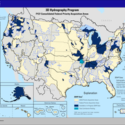
FY27 DCA 3DHP-F Consolidated Federal Priority Acquisition Areas
FY27 DCA 3DHP-F Consolidated Federal Priority Acquisition Areas