
Just how many thermal features are there in Yellowstone?
Yellowstone National park hosts more than 10,000 hydrothermal features including hot springs, geysers, fumaroles, and mud pots. But did you know that park personnel document every one of those features...in person?
Yellowstone Caldera Chronicles is a weekly column written by scientists and collaborators of the Yellowstone Volcano Observatory. This week's contribution is from Behnaz Hosseini, Geoscientist, and Jefferson Hungerford, Park Geologist, at the Yellowstone Center for Resources in Yellowstone National Park.
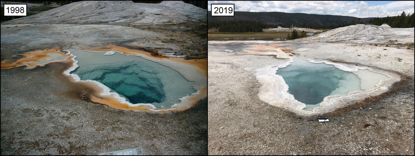
We often see in news articles and documentaries that Yellowstone National Park hosts more than 10,000 hydrothermal features, which include hot springs, geysers, fumaroles, and mud pots. Did you ever wonder where this number comes from? You may be surprised to learn that park personnel documented, in person, every single one of the 10,000 features. This first iteration of this hydrothermal inventory project, or "HIP" for short, was a ten-year effort that began in 1998 and ended in 2007.
In summer 2018, a team from Yellowstone National Park's Geology Program began the second iteration of HIP surveys. This next-generation HIP began in Norris Geyser Basin last year, and this year is focused on the Upper Geyser Basin, where Old Faithful is located. In fact, if you visited the Upper Geyser Basin this summer, you may have spotted Yellowstone geologists hard at work inventorying your favorite geysers and hot springs.
To date, the 2019 Upper Geyser Basin inventory effort has yielded a whopping 1,350 features, compared to the 670 mapped in the first inventory cycle. To give a few examples, the team inventoried 146 features in Biscuit Basin, where previously 28 were identified. Likewise, the team inventoried 102 features in Black Sand Basin, where previously 18 were inventoried. And last year, the Geology Program inventoried 1,100 features in the Norris Geyser Basin, whereas the last survey group inventoried 480 features.
The reason for the increase in documented thermal features is due to how features are now defined, rather than some geological cause. Between the first and second HIP, there was a change in inventory protocol—specifically, the types of features that were included in the inventory. Smaller features that were not included or grouped with other features during the first HIP are classified as independent features in the second survey.
Why do we inventory hydrothermal features, you might ask? A key aspect of the National Park Service's mission is to preserve and protect natural resources for the enjoyment and education of present and future generations. To do so, we must must know where, and in what quantities and varieties, these hydrothermal features exist. The Geology Program team—equipped with high-accuracy GPS receivers, iPads, and various sensors—walks from feature to feature to precisely document this information. Among the types of information collected are parameters such as pH and water conductivity, as well as the physical characteristics, activity, number of vents, and other observations of each feature.
While working on the HIP, the Geology Program team entertains great questions from park visitors. Commonly asked questions are:
How do you decide if a feature should be considered separately or clustered with others?
The team documents every distinct surface expression of a hydrothermal feature. If many vents lie in a hot spring, for example, the vents are counted as multiple vents in one feature. If a vent is clearly distinct from others, it is inventoried as a single feature. That said, sometimes dangerous terrain necessitates the grouping of features due to inaccessibility.
How much have characteristics of a certain feature or area changed since the previous inventory?
Ironically, change is a constant in Yellowstone, and assessing change is not as simple as comparing data from one inventory cycle to the next. Some features, given their type, will change drastically—even becoming extinct!—and some will change minimally. And, of course, new features pop up, too!
How do you walk safely in hydrothermal areas?
Working in hydrothermal areas is extremely hazardous. The Geology Program team, however, takes actions to mitigate risk. The team is trained by the Park Geologist and always equipped with first-aid kits and radios, and team members wear personal protective equipment to guard against high temperatures. They also know how to recognize unstable ground and stay away from areas that may not be safe to walk on. Hydrothermal areas are exceedingly dangerous and delicate, so it is important that visitors always stay on designated boardwalks and trails to ensure safety and to protect the fragile features.
The Geology Program has changed the way hydrothermal features are counted since the first cycle of the HIP. Yes, we are counting more features, but will this new HIP effort vastly increase the more than 10,000 figure we report to our visitors and the media? Stay tuned: this inventory process will take a few years to complete!