
The U.S. Geological Survey Alaska Science Center is working in cooperation with the City and Borough of Juneau (CBJ), Alaska Department of Transportation and Public Facilities (ADOT&PF), and the Corps of Engineers (COE) to provide real-time warning of an impending glacial outburst flood and monitor Mendenhall River conditions during the flood.
Return to Water
The U.S. Geological Survey Alaska Science Center is working in cooperation with the City and Borough of Juneau (CBJ), Alaska Department of Transportation and Public Facilities (ADOT&PF), and the Corps of Engineers (COE) to provide real-time warning of an impending glacial outburst flood and monitor Mendenhall River conditions during the flood. Glacial outburst floods began at this location in 2011, occur annually, and reached record levels in 2023 and 2024. The 2024 flood impacted over 300 homes and CBJ has installed flood mitigation measures along the river. Release from the glacier dammed lake is expected sometime in the next two weeks.
The USGS Alaska Science Center monitors conditions in the glacier dammed basin with two satellite modem cameras and a laser to track water and ice levels. This information is used by the National Weather Service to forecast the timing and magnitude of the outburst flood peak and allows managers to anticipate potential flooding and make informed decision regarding evacuations and road closures before levels begin to rise at Mendenhall Lake and in the Mendenhall River.
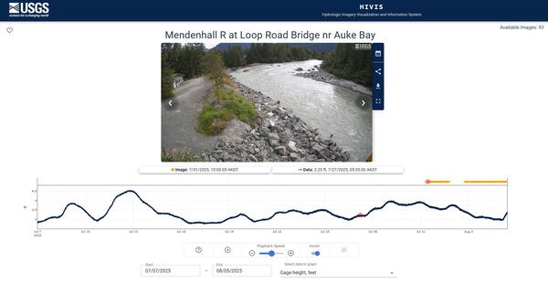
Downstream of the glacier, the USGS gage on Mendenhall Lake measures water temperature and water elevation every 15 minutes. A decrease in water temperature in association with a rise in lake level helps to distinguish water releasing from the glacially dammed lake from rainfall runoff. In cooperation with the COE, the USGS installed three stage and velocity sensors on downstream bridges over the Mendenhall River. This information will be used to calibrate flood inundation models and evaluate the effectiveness of the flood mitigation measures. Cameras installed at the bridges provide near-real time views of the river and will be updating to the USGS HIVIS page every minute during the flood. USGS will collect channel sounding data at the bridges during the flood recession for ADOT&PF to determine if the bridges are safe for reopening.
Quick Links