
USGS staff inspecting monitoring equipment in Suicide Basin. Suicide Basin is a side basin of the Mendenhall Glacier above Juneau, Alaska.
Jeff Conaway
Surface-water modeling, sediment transport, acoustic Doppler current profilers
Science and Products
Filter Total Items: 26

Alaska Streamflow Statistics
The USGS conducts various studies of streamflow statistics for data collected at streamflow-gaging stations. Streamflow statistics for gaged streams and methods for estimating those statistics for ungaged streams are used by water resource planners and managers for designing infrastructure, managing floodplains, and protecting life, property, and aquatic resources. The most recent USGS studies of...
Indigenous Community Outreach and Engagement Indigenous Community Outreach and Engagement
It is critically important that Indigenous peoples, rural communities, and Alaska co-management councils are kept informed of USGS research activities and findings. Involvement of and collaboration with these stakeholders provides valuable perspectives. This page offers information on how USGS communicates and seeks out important perspectives from stakeholders.

USGS Alaska Streamgage Datum to North American Vertical Datum of 1988 Conversion Table
To obtain stream water-surface elevation values in NAVD88 add the following conversion factor to gage height values.

Unuk River
The Unuk River is the second smallest watershed in the transboundary study of Southeast Alaska, but has three large mining projects in development (Kerr-Sulplherets-Mitchell (KSM), Brucejack, and Eskay Creek).

Alsek River
The Alsek River is the furthest north watershed in the transboundary study of Southeast Alaska, reaching 300 miles north of Haines Junction, Yukon Territory.

Stikine River
The Stikine River near Wrangell and Petersburg is the largest watershed in the transboundary study of Southeast Alaska.

Taku River
Adverse water quality from a trio of historic mines in the Tulsequah River watershed, a tributary of the Taku River, have caused concern in local communities including Juneau, Alaska, and Atlin, British Columbia

Salmon River
The Salmon River, located near Hyder, Alaska, and Stewart, British Columbia, is the smallest watershed in the transboundary study of Southeast Alaska.
Q&A: USGS Ecosystems Provides Objective Science to Manage Lands, Fish, and Wildlife
The USGS Ecosystems Mission Area is the only program within the Department of Interior (DOI) focused on generating science to inform the management of the nation’s lands, fish, and wildlife. The Ecosystems Mission Area is also the only entity with the specific role of meeting the information needs of DOI agencies (e.g., Bureau of Land Management, Bureau of Ocean Energy Management, National Park...

Q&A: The Role of USGS Ecosystems Science in Alaska
The USGS is the science arm of the Department of the Interior (DOI) with a mission to provide timely and impartial science information to decision-makers, industry, and others. Topics of USGS research and monitoring in Alaska include Ecosystems, Energy and Minerals, Geology, Water Resources, and Natural Hazards. At the Ecosystems Office of the USGS Alaska Science Center, research and monitoring...

Q&A: USGS Ecosystems Science Provides Information on Subsistence and Hunter-Harvested Food Resources in Alaska
The USGS is the science arm of the Department of the Interior with a mission to provide timely and impartial science information to decision-makers, industry, tribal entities and others. In Alaska, subsistence and hunter-harvested foods are kitchen table issues for the public. The annual subsistence harvest per rural resident is 295 pounds of wild food. USGS science is responsive to subsistence...

Q&A: USGS and the 2025 Anchorage Bike to Work Day
For the May 16, 2025, Anchorage Bike to Work Day, the USGS Alaska Science Center will again host a station along the Lanie Fleischer Chester Creek Trail where people can learn about the USGS streamgage on the creek and about the common birds of Chanshtnu. Chester Creek or Chanshtnu, which means ‘grass creek’ in the Dena’ina language, runs for about 20 miles from the Chugach mountains in the...
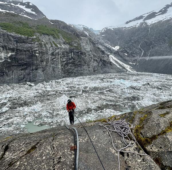
Suicide Basin above Juneau Alaska
USGS staff inspecting monitoring equipment in Suicide Basin. Suicide Basin is a side basin of the Mendenhall Glacier above Juneau, Alaska.

Timelapse of Anchor River at Anchor Point in Alaska
Timelapse of Anchor River at Anchor Point in AlaskaTwo cameras were installed in December of 2024 on the Anchor River to monitor flooding associated with river ice. Traditional hydrologic monitoring is often ineffective when rivers freeze and break up and the cameras provide information needed by our partners to verify water levels and issue flood forecasts.
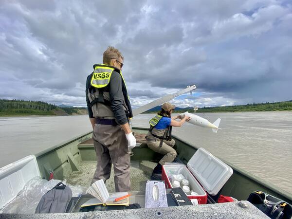
USGS staff collecting water quality samples on the Yukon River at Eagle
USGS staff collecting water quality samples on the Yukon River at EagleUSGS staff sample the Yukon River for cyanide after a heap leach failure occurred upstream at the Eagle Gold Mine in the Yukon, Canada.
USGS staff collecting water quality samples on the Yukon River at Eagle
USGS staff collecting water quality samples on the Yukon River at EagleUSGS staff sample the Yukon River for cyanide after a heap leach failure occurred upstream at the Eagle Gold Mine in the Yukon, Canada.

Wolverine tracks
Wolverine tracks in the snow on Crescent Lake near the Moose Pass Alaska. The wolverine is the largest terrestrial member of the family Mustelidae and is a relative of the mink and weasel.
Wolverine tracks in the snow on Crescent Lake near the Moose Pass Alaska. The wolverine is the largest terrestrial member of the family Mustelidae and is a relative of the mink and weasel.

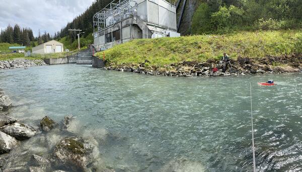
Streamflow discharge measurement at Solomon Gulch Tailrace, Valdez, Alaska
Streamflow discharge measurement at Solomon Gulch Tailrace, Valdez, AlaskaUSGS staff measuring streamflow at the Solomon Gulch Tailrace with a tethered Acoustic Doppler Current Profiler. This is one of 12 streamgages that the USGS Alaska Science Center operates in cooperation with hydropower providers across Alaska. Data are used for operation, regulation, and planning purposes.
Solomon Gulch
USGS staff measuring discharge at the Solomon Gulch Hydropower tailrace, Valdez Alaska.
USGS staff measuring discharge at the Solomon Gulch Hydropower tailrace, Valdez Alaska.

An aerial view of McKinley Lake, outside of Cordova, Alaska
An aerial view of McKinley Lake, outside of Cordova, AlaskaMcKinley Lake, outside of Cordova, Alaska. This is the site of deployment of limnocorrals for an Elodea spp. experiment.
An aerial view of McKinley Lake, outside of Cordova, Alaska
An aerial view of McKinley Lake, outside of Cordova, AlaskaMcKinley Lake, outside of Cordova, Alaska. This is the site of deployment of limnocorrals for an Elodea spp. experiment.

USGS Station streamgage 15905100 at the Atigun River, Alaska
USGS Station streamgage 15905100 at the Atigun River, AlaskaStreamgage number 15905100 at the Atigun River, Alaska. The Alyeska oil pipeline is in the background.
USGS Station streamgage 15905100 at the Atigun River, Alaska
USGS Station streamgage 15905100 at the Atigun River, AlaskaStreamgage number 15905100 at the Atigun River, Alaska. The Alyeska oil pipeline is in the background.

Sounding weight on the Copper River Delta, Alaska
Sounding weight on the Copper River Delta, Alaska
Sounding weight on the Copper River Delta, Alaska
Science and Products
Filter Total Items: 26
Alaska Streamflow Statistics
The USGS conducts various studies of streamflow statistics for data collected at streamflow-gaging stations. Streamflow statistics for gaged streams and methods for estimating those statistics for ungaged streams are used by water resource planners and managers for designing infrastructure, managing floodplains, and protecting life, property, and aquatic resources. The most recent USGS studies of...
Indigenous Community Outreach and Engagement Indigenous Community Outreach and Engagement
It is critically important that Indigenous peoples, rural communities, and Alaska co-management councils are kept informed of USGS research activities and findings. Involvement of and collaboration with these stakeholders provides valuable perspectives. This page offers information on how USGS communicates and seeks out important perspectives from stakeholders.
USGS Alaska Streamgage Datum to North American Vertical Datum of 1988 Conversion Table
To obtain stream water-surface elevation values in NAVD88 add the following conversion factor to gage height values.
Unuk River
The Unuk River is the second smallest watershed in the transboundary study of Southeast Alaska, but has three large mining projects in development (Kerr-Sulplherets-Mitchell (KSM), Brucejack, and Eskay Creek).
Alsek River
The Alsek River is the furthest north watershed in the transboundary study of Southeast Alaska, reaching 300 miles north of Haines Junction, Yukon Territory.
Stikine River
The Stikine River near Wrangell and Petersburg is the largest watershed in the transboundary study of Southeast Alaska.
Taku River
Adverse water quality from a trio of historic mines in the Tulsequah River watershed, a tributary of the Taku River, have caused concern in local communities including Juneau, Alaska, and Atlin, British Columbia
Salmon River
The Salmon River, located near Hyder, Alaska, and Stewart, British Columbia, is the smallest watershed in the transboundary study of Southeast Alaska.
Q&A: USGS Ecosystems Provides Objective Science to Manage Lands, Fish, and Wildlife
The USGS Ecosystems Mission Area is the only program within the Department of Interior (DOI) focused on generating science to inform the management of the nation’s lands, fish, and wildlife. The Ecosystems Mission Area is also the only entity with the specific role of meeting the information needs of DOI agencies (e.g., Bureau of Land Management, Bureau of Ocean Energy Management, National Park...
Q&A: The Role of USGS Ecosystems Science in Alaska
The USGS is the science arm of the Department of the Interior (DOI) with a mission to provide timely and impartial science information to decision-makers, industry, and others. Topics of USGS research and monitoring in Alaska include Ecosystems, Energy and Minerals, Geology, Water Resources, and Natural Hazards. At the Ecosystems Office of the USGS Alaska Science Center, research and monitoring...
Q&A: USGS Ecosystems Science Provides Information on Subsistence and Hunter-Harvested Food Resources in Alaska
The USGS is the science arm of the Department of the Interior with a mission to provide timely and impartial science information to decision-makers, industry, tribal entities and others. In Alaska, subsistence and hunter-harvested foods are kitchen table issues for the public. The annual subsistence harvest per rural resident is 295 pounds of wild food. USGS science is responsive to subsistence...
Q&A: USGS and the 2025 Anchorage Bike to Work Day
For the May 16, 2025, Anchorage Bike to Work Day, the USGS Alaska Science Center will again host a station along the Lanie Fleischer Chester Creek Trail where people can learn about the USGS streamgage on the creek and about the common birds of Chanshtnu. Chester Creek or Chanshtnu, which means ‘grass creek’ in the Dena’ina language, runs for about 20 miles from the Chugach mountains in the...
Suicide Basin above Juneau Alaska
USGS staff inspecting monitoring equipment in Suicide Basin. Suicide Basin is a side basin of the Mendenhall Glacier above Juneau, Alaska.
USGS staff inspecting monitoring equipment in Suicide Basin. Suicide Basin is a side basin of the Mendenhall Glacier above Juneau, Alaska.
Timelapse of Anchor River at Anchor Point in Alaska
Timelapse of Anchor River at Anchor Point in AlaskaTwo cameras were installed in December of 2024 on the Anchor River to monitor flooding associated with river ice. Traditional hydrologic monitoring is often ineffective when rivers freeze and break up and the cameras provide information needed by our partners to verify water levels and issue flood forecasts.
USGS staff collecting water quality samples on the Yukon River at Eagle
USGS staff collecting water quality samples on the Yukon River at EagleUSGS staff sample the Yukon River for cyanide after a heap leach failure occurred upstream at the Eagle Gold Mine in the Yukon, Canada.
USGS staff collecting water quality samples on the Yukon River at Eagle
USGS staff collecting water quality samples on the Yukon River at EagleUSGS staff sample the Yukon River for cyanide after a heap leach failure occurred upstream at the Eagle Gold Mine in the Yukon, Canada.
Wolverine tracks
Wolverine tracks in the snow on Crescent Lake near the Moose Pass Alaska. The wolverine is the largest terrestrial member of the family Mustelidae and is a relative of the mink and weasel.
Wolverine tracks in the snow on Crescent Lake near the Moose Pass Alaska. The wolverine is the largest terrestrial member of the family Mustelidae and is a relative of the mink and weasel.
Streamflow discharge measurement at Solomon Gulch Tailrace, Valdez, Alaska
Streamflow discharge measurement at Solomon Gulch Tailrace, Valdez, AlaskaUSGS staff measuring streamflow at the Solomon Gulch Tailrace with a tethered Acoustic Doppler Current Profiler. This is one of 12 streamgages that the USGS Alaska Science Center operates in cooperation with hydropower providers across Alaska. Data are used for operation, regulation, and planning purposes.
Solomon Gulch
USGS staff measuring discharge at the Solomon Gulch Hydropower tailrace, Valdez Alaska.
USGS staff measuring discharge at the Solomon Gulch Hydropower tailrace, Valdez Alaska.
An aerial view of McKinley Lake, outside of Cordova, Alaska
An aerial view of McKinley Lake, outside of Cordova, AlaskaMcKinley Lake, outside of Cordova, Alaska. This is the site of deployment of limnocorrals for an Elodea spp. experiment.
An aerial view of McKinley Lake, outside of Cordova, Alaska
An aerial view of McKinley Lake, outside of Cordova, AlaskaMcKinley Lake, outside of Cordova, Alaska. This is the site of deployment of limnocorrals for an Elodea spp. experiment.
USGS Station streamgage 15905100 at the Atigun River, Alaska
USGS Station streamgage 15905100 at the Atigun River, AlaskaStreamgage number 15905100 at the Atigun River, Alaska. The Alyeska oil pipeline is in the background.
USGS Station streamgage 15905100 at the Atigun River, Alaska
USGS Station streamgage 15905100 at the Atigun River, AlaskaStreamgage number 15905100 at the Atigun River, Alaska. The Alyeska oil pipeline is in the background.
Sounding weight on the Copper River Delta, Alaska
Sounding weight on the Copper River Delta, Alaska
Sounding weight on the Copper River Delta, Alaska