
Simulation of Groundwater Flow in the Madison and Minnelusa Aquifers, Black Hills Area
Project Period: 2011-2018
Cooperator: National Park Service, Black Hills National Forest, City of Rapid City, West Dakota Water Development District
Project Chief: Bill Eldridge
Executive Summary
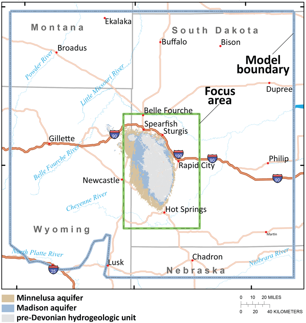
The Madison and Minnelusa aquifers are critically important water resources that were a primary focus of the Black Hills Hydrology Study of the 1990s. These aquifers have a large influence on surface-water systems and provide the most important source of groundwater for municipal, domestic, agricultural, and industrial use in the area. Rapidly increasing demand from these aquifers may affect groundwater availability and surface-water resources.
Our aim is to construct a groundwater flow model of the Madison and Minnelusa aquifers for the Black Hills and surrounding area to help address hydrologic questions on local and regional scales. Several parties in the Black Hills area, including the National Park Service and the Black Hills National Forest, have sought answers to questions concerning groundwater—the primary water supply for this area. These questions are summarized by three questions of broad scope: (1) What is the influence of the regional aquifer on local groundwater flow? (2) What is the aquifer sustainability in different areas to pumping and drought? (3) How might future data collection efforts be planned most effectively? These questions are difficult, or impossible, to answer objectively without rigorous quantification of numerous local and regional hydrologic influences on groundwater. A three-dimensional groundwater flow model for the Black Hills area would provide these estimates better than any other known method and provide a tool that will help define sustainable groundwater use for the Black Hills area. The U.S. Geological Survey (USGS) previously has developed site-specific models of the Madison and Minnelusa aquifers for the Rapid City and Spearfish areas. The need for updated models in these and other areas is expected to continue in the long-term future.
Developing a regional groundwater flow model that includes the entire Black Hills area will have several benefits over a continuation of site-specific modeling efforts:
- Developing a single regional model would be more cost effective than multiple smaller models.
- Simulation of site-specific areas (e.g., Rapid City) is more accurate when placed within a regional flow model.
- Artesian springs are critical water sources that capture groundwater from regional areas and thus are best simulated with a regional model.
- The model grid can be modified for high-resolution simulations in any area of special interest or to answer specific hydrologic questions (e.g., the effects of pumping in a small area).
- As additional future questions arise, other hydrologic scenarios can be cost-effectively evaluated without the need for new site-specific models.
Until recently, the success of developing a meaningful and useful model for the entire Black Hills area would have been questionable. Since the completion of the Black Hills Hydrology Study, a wealth of new data have been collected, and this combined with our improved conceptual understanding of groundwater flow in the area and recently developed modeling capabilities make this effort now feasible. The model will be designed to address current objectives and hydrologic questions but also will have a generic underlying structure for adaptation to future objectives and model refinement. This model is envisioned as a long-term tool that will be available for numerous future studies and will symbiotically benefit multiple interested parties.
Objectives
Study objectives are to (1) better understand the influence of regional groundwater flow on local groundwater; (2) assess the effects of pumping and drought on groundwater availability; and (3) help guide further data collection efforts.

Project Period: 2011-2018
Cooperator: National Park Service, Black Hills National Forest, City of Rapid City, West Dakota Water Development District
Project Chief: Bill Eldridge
Executive Summary
The Madison and Minnelusa aquifers are critically important water resources that were a primary focus of the Black Hills Hydrology Study of the 1990s. These aquifers have a large influence on surface-water systems and provide the most important source of groundwater for municipal, domestic, agricultural, and industrial use in the area. Rapidly increasing demand from these aquifers may affect groundwater availability and surface-water resources.
Our aim is to construct a groundwater flow model of the Madison and Minnelusa aquifers for the Black Hills and surrounding area to help address hydrologic questions on local and regional scales. Several parties in the Black Hills area, including the National Park Service and the Black Hills National Forest, have sought answers to questions concerning groundwater—the primary water supply for this area. These questions are summarized by three questions of broad scope: (1) What is the influence of the regional aquifer on local groundwater flow? (2) What is the aquifer sustainability in different areas to pumping and drought? (3) How might future data collection efforts be planned most effectively? These questions are difficult, or impossible, to answer objectively without rigorous quantification of numerous local and regional hydrologic influences on groundwater. A three-dimensional groundwater flow model for the Black Hills area would provide these estimates better than any other known method and provide a tool that will help define sustainable groundwater use for the Black Hills area. The U.S. Geological Survey (USGS) previously has developed site-specific models of the Madison and Minnelusa aquifers for the Rapid City and Spearfish areas. The need for updated models in these and other areas is expected to continue in the long-term future.
Developing a regional groundwater flow model that includes the entire Black Hills area will have several benefits over a continuation of site-specific modeling efforts:
- Developing a single regional model would be more cost effective than multiple smaller models.
- Simulation of site-specific areas (e.g., Rapid City) is more accurate when placed within a regional flow model.
- Artesian springs are critical water sources that capture groundwater from regional areas and thus are best simulated with a regional model.
- The model grid can be modified for high-resolution simulations in any area of special interest or to answer specific hydrologic questions (e.g., the effects of pumping in a small area).
- As additional future questions arise, other hydrologic scenarios can be cost-effectively evaluated without the need for new site-specific models.
Until recently, the success of developing a meaningful and useful model for the entire Black Hills area would have been questionable. Since the completion of the Black Hills Hydrology Study, a wealth of new data have been collected, and this combined with our improved conceptual understanding of groundwater flow in the area and recently developed modeling capabilities make this effort now feasible. The model will be designed to address current objectives and hydrologic questions but also will have a generic underlying structure for adaptation to future objectives and model refinement. This model is envisioned as a long-term tool that will be available for numerous future studies and will symbiotically benefit multiple interested parties.
Objectives
Study objectives are to (1) better understand the influence of regional groundwater flow on local groundwater; (2) assess the effects of pumping and drought on groundwater availability; and (3) help guide further data collection efforts.