



Tracking Monarch Butterflies with Bio-loggers: A Technology Overview for Practitioners
The U.S. Geological Survey collaborated with researchers and commercial vendors to provide an overview of the current technologies used to track monarch butterflies as well as guidance on understanding the tracking data.
Tracking Technologies
Tags Used for Monarchs and Other Small Wildlife
Communication systems
Interpreting Tracking Data
Any use of trade, firm, or product names is for descriptive purposes only and does not imply endorsement by the U.S. Government.
Background
Recent technological breakthroughs in lightweight radio transmitters are empowering researchers to track individual monarch butterflies and other small animals in ways that were not possible a few years ago. These tools can provide valuable insights into where monarchs, and other insects, birds, and bats travel, how far they move, and how they use habitats during migrations and within or across seasons. However, many practitioners may be unfamiliar with the technology behind these tracking systems, what types of data they produce, or how to interpret those data.
This is a practical introduction to the technologies currently used to track monarchs, the commercially available devices, and what users can expect from the resulting data. We developed it for those researching monarchs or resource managers who have the opportunity to interpret data from these devices. A companion best practices guide will offer additional analytical suggestions for these unique data. The information presented on this site is current as of its publication. Technology is rapidly evolving and we will update this site as the technology changes and as funding allows.
USGS Role
The U.S. Geological Survey (USGS) tracks monarch butterflies and other small wildlife across North America. Our scientists address research needs to inform conservation decisions. In 2026, USGS scientists and others deployed a large number of tracking tags on monarchs in Mexico and in parts of the USA. USGS is currently developing guidance and tools for analyses of these novel data.
Tracking Technologies
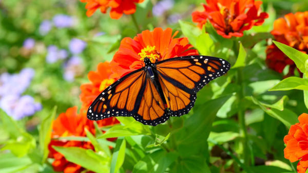
Tracking individual insects with bio-logging devices relies on two related communication technologies, the Motus system - which is also used to track birds and bats - and Bluetooth Low Energy (BLE) communications. Currently, three types of tags have been used to track monarchs (Table 1). Table 1 includes details on multiple devices that work on Motus and BLE, many of which are too heavy to be used on monarchs. Information about these larger tags and their capabilities can provide insight into potential future options for monarch tracking.
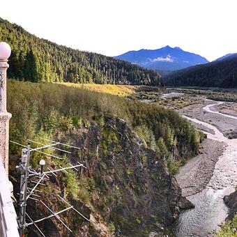
Motus Wildlife Tracking System. The Motus network detects signals from Motus-compatible tags. Motus has been used to track thousands of birds, bats, and insects. A Motus-compatible tag is attached to an animal and when that animal passes by a Motus receiver, the tag’s signal is detected. The date and time of that detection are recorded and stored at the station or transmitted over the internet to a dedicated server. Receivers (also called “stations”) are installed by those who wish to study animal movements or to highlight the value of an area for moving animals.
The Motus network can use radio signals on five radio frequencies: 150.100, 151.500, 166.380, 434MHz, and 2.4GHz. 2.4GHz is the same frequency used by Bluetooth. Only 166.380MHz, 434MHz and 2.4GHz are used in the Americas; the other frequencies are used in other parts of the world. Frequencies used to date for tracking monarchs are 2.4GHz and 166.380MHz (Table 1), meaning that the many Motus receivers that do not receive those frequencies are not equipped to receive signals from monarch tracking devices. The Motus web page has a map showing the locations of thousands of stations around the globe and the frequencies received by each.
Bluetooth Low Energy. Bluetooth Low Energy (BLE) allows smartphones to act as sensors, functioning as a crowd-sourced “network” of wildlife receivers. BLE is distinct from the Classic Bluetooth used to stream music or make calls from a car or a headset. Specifically, Classic Bluetooth handles larger data packets required for calls or streaming, whereas BLE is designed specifically for communications among networks of smartphones and for sending small, infrequent data packets. Both BLE and Classic Bluetooth operate on 2.4GHz, both have similar range of up to about 100m line of sight on land, and both are enabled on most modern smartphones.
BLE has many applications. Perhaps the most familiar of these are Apple “AirTags” and the Life360 “Tile” tags for Android devices. Both devices use BLE networks to locate and track luggage or other items of value. The BLE networks are created from the millions of smartphones that many of us carry. Each smartphone can receive data over BLE and transmit them anonymously via the internet to a server. BLE tracking via the Apple “FindMy” system was initially limited to Apple devices. However, the system has now been opened to third-party BLE devices, although those devices still must be detected by an Apple phone to use the FindMy network. This has resulted in a rapid growth of the number of applications using this system, including for wildlife tracking. A major difference between wildlife tracking with BLE vs Motus is that far more data are received from an animal tracked by BLE than by Motus. This is because there are so many smartphones that can serve as receivers. Another difference is that Motus receivers are in fixed spots and often in remote areas where scientists want to try to track animals. BLE receivers are wherever there are people with smartphones, and so detections will be more likely in places with lots of people – near roads and population centers.
Other Approaches. There are other technologies that have been used to track insects. These include: (1) evaluating isotope composition of tissue; (2) affixing lightweight diodes to insects for tracking with radar; or (3) field surveys of visual markers on insects. These “passive” tracking technologies are not covered here.
Tags Used for Monarchs and Other Small Wildlife
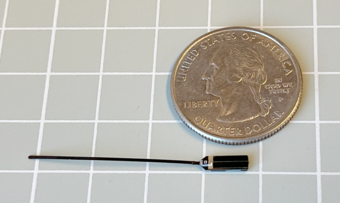
Tracking devices that transmit over 2.4GHz and leverage the BLE network have been custom built by academics and are commercially produced by two firms - Interrex and Cellular Tracking Technologies (CTT). Table 1 compares tag types and capabilities. The tracking devices shown in Table 1 and described below, when deployed on monarchs and other animals, can have impacts to movement behavior, flight capacity, and survival. These factors are not covered here.
Tag Types
The most commonly used devices currently used for monarch tracking are the BlūMorpho tags from CTT. These come in two versions, BlūMorpho Standard and BlūMorpho Expanded. BlūMorpho Standard works exclusively with the 2.4 GHz Motus system. BlūMorpho Expanded works with both the 2.4 GHz Motus system and BLE. Other tags manufactured by CTT that work with both Motus and BLE are the BlūBat, BlūBird, LifeTags, PowerTags, and HybridTags.
Lotek manufactures 166MHz tags that have, in the past, been used on some monarchs and are Motus-compatible. The Lotek tags, called NanoTags or NanoTags Solar, are not BLE enabled and are not detected on the broader Bluetooth network.
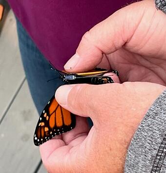
Some tags that use the Motus network can also send data from onboard sensors measuring variables such as actual location, air temperature, or on-board solar panel readings or battery voltage.
The company Interrex has displayed insect-sized, BLE-enabled devices at professional conferences. Little information is available on these tags, although it appears that two types, the "Ultra" and "Nano", will become available. Both collect GPS data, both weigh 1.7-3.7g. Radio transmissions by these devices can be on 2.4GHz but they currently do not work on the Motus network.
The BlūMorpho (Standard and Expanded) and LifeTag devices are solar powered and do not have an on-board battery. Their lifespan is indefinite, but if the onboard capacitor is not charged - or recharged - it cannot send data.
The NanoTags, BlūBat, and Power tags are battery powered. This adds weight to the tag, and gives it a fixed life span.
NanoTag Solar, BlūBird, Hybrid Tags, and the Ultra and Nano have both a battery and a solar charger. This makes them heavier than a solar tag, but with longer lifespan than tags that have only a battery. Having a battery enables the tag to communicate under a broader range of conditions - for example on cloudy days - than a lighter tag that is exclusively solar powered.
Communication systems
Of the tags noted above, only the Expanded version of the BlūMorpho, BlūBat, and BlūBird transmitters can send data via both Motus and BLE. Communication via the “FindMy” network for wildlife applications is available using Apple computers, tablets, or smartphones. The only data produced by this network are date, time, receiver location, and a confidence score. A Blū tag with the Blū+ service can connect to an Android phone running a specialized app but cannot use the “Life360” crowdsourced network. These tags also can send additional sensor data over the 2.4GHz Motus network.
Motus receivers are built by Lotek, CTT, or by non-commercial parties. BLE receivers (other than phones) for wildlife tracking are manufactured by CTT and Interrex. A BLE receiver and antenna can be added to a CTT SensorStation – one type of Motus receiver - so it can collect both Motus and BLE data.
Two other CTT receivers, the “Terra” and “Node,” can also detect BLE tags. Terra stations are designed to detect animal sounds as well as transmissions from Motus and BLE devices. Nodes can transmit detections wirelessly to a SensorStation within about 1 km, or they can save the data internally for manual download. Nodes are completely powered by a small solar panel and rechargeable battery and so are well suited for deployment in remote areas.
CTT BLE tags can also be detected with the CTT “Sidekick,” a small handheld receiver connected to an omni directional antenna or a Yagi antenna purposely built for Bluetooth signals.
The Interrex “Hub” is a receiver with a Bluetooth antenna. There is limited publicly available information about the “Hub”, but from available images, appears to have similar capabilities as the CTT “Sidekick.”
The Apple “FindMy” network functions automatically with any iPhone or other Apple device. These detections are anonymous – the owner of the phone is not identified, and the owner doesn’t know that the network is using their phone. Data collected and transmitted over the FindMy network are referred to as “crowd sourced”.
The “Project Monarch” app is available for both Apple and Android phones. It uses the phone’s Bluetooth receiver to detect BLE-enabled Blū devices. When turned on, the app scans for Blū devices and shows the user which tags it detects – doing this removes the anonymity from the process (i.e., information on the phone is shared via the app and, by using the app, the user is specifically agreeing that this information can be shared). These data are “app-based”. The app lets an Android phone work like an Apple device by detecting and recording Blū devices. The app also allows users to see movement of large numbers of butterflies that have been tracked by Blū devices.
Other considerations
Cost of a BLE tag (\$200-300 USD) is low compared to that of a GPS-enabled device used to track larger birds and mammals (~\$1000 USD). However, studying insects often involves tagging far greater numbers of animals than does studying larger animals. Consequently, costs may be high for a single study of insects. Other costs to consider are a typical fee for each day the tag is sending data, and additional monthly costs for the Blu+ service. Typically, data costs and Motus registration need to be paid before the tag is deployed. Contact manufacturers directly for current prices.
Interpreting Tracking Data
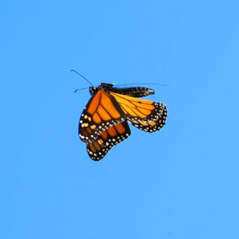
It is important to understand what the data from a BLE tag look like, how they can be interpreted, who owns them, and how to analyze them. The information in this section is drawn from CTT’s website, the only company to publicly post information on their technology. Due to limits in how data are transmitted, data from other BLE tags will be similar, although there may be subtle differences depending on the manufacturer. These differences might involve how you access the data or how the data are downloaded.
Once a tag is detected, either by BLE or Motus, the resulting data fields typically include the data source - app-based, crowd-sourced, or Motus, the receiver ID - not available for crowd-sourced data from smartphones, tag ID, date and time of detection, and the latitude and longitude of the receiver. Detections over a BLE network will also be associated with a confidence score that ranges from 1 to 255 that serves as an indicator of certainty about the location. The formula for the confidence score is proprietary (to Apple) and the best way to interpret the confidence score is still being evaluated. At present it appears that confidence scores closer to 1 indicate the tag was closer to the receiver and locations have higher precision. Scores closer to 255 appear to indicate the tag was farther from the receiver, and the location has less precision. Thus, it appears that the confidence score likely responds to signal strength, accuracy, precision, and distance from the receiver. Environmental factors, such as temperature and wind speed, and the presence of obstructions, may also influence confidence scores.
A detection recorded via the Motus network includes an indicator of signal strength, called “RSSI”. RSSI values typically range from 0 to -100, with higher values, those closer to zero, indicating a stronger signal. RSSI can be used to estimate distance from the receiver to the tag.
There are several special considerations that are helpful to remember when interpreting BLE tracking data. These include:
- Receiver location ≠ animal location. Unlike GPS devices, Motus and BLE detections record the receiver’s location not the animal’s position. Thus, these data only indicate an animal was close enough to the receiver to send data. The actual location of the animal is unknown. This is an important distinction when interpreting movements, especially at fine spatial scales. Detection by multiple devices simultaneously could, theoretically, be used to refine location estimates.
- Geographic detection bias. BLE detections tend to be biased towards population centers, roads, and other places used by humans with smartphones. Studies using BLE technology that try to answer questions about resource selection or resource use are best designed cautiously, so that they are not influenced by this geographic bias. For example, an improperly designed study might incorrectly conclude that monarchs prefer being near cities since detections are more likely near cities.
- Detection range. BLE has a maximum detection distance of 30-100m, depending on environmental conditions. Detection distances for Motus 2.4GHz transmissions range up to several kilometers. Since detection data are associated with information on how the detection occurred, these details can inform their interpretation.
- Signal error. The RSSI value and the confidence score provide a measure of error in location. RSSI is well understood and its values can even be used to triangulate the location of the animal if the tag is detected by multiple antennas. Because confidence scores are not as well understood they have, to date, not been effectively used for refining location estimates. Some users have suggested “thresholding” - only considering signals with a confidence score below an arbitrary value (e.g., some have suggested 150 as a threshold).
To order CTT tags, current protocols are that users must first provide their Motus Project ID, ensuring tags are automatically registered to their project upon shipment. Deployment data are entered directly into the Motus portal, while tag activation is handled physically or via solar exposure. All Motus-network detection data, including integrated sensor data like temperature and voltage, are accessed and downloaded directly through the Motus platform. These protocols change frequently and users are advised to check with the manufacturer for current tag activation processes.
Data are owned by the purchaser of the tag, although basic maps are publicly available through the Project Monarch app. CTT retains the right to access tag data to provide services for diagnostic uses and analytics, per their Terms of Service. Much of the early BlūMorpho data are shared through a research collaborative that includes many of the early users of this technology. This research collaborative, and access to the data, are in the early stages of development.
Table 1: Summary of tag technologies and capabilities for Monarchs and small wildlife
Summary of tag capabilities and technologies for devices used to track monarchs and other small wildlife. All listed devices can transmit over frequencies associated with Motus networks, although their radio frequency, power source, and Bluetooth Low Energy (BLE) capabilities vary. Some devices have batteries onboard, others have only solar panels and a capacitor, and some are able to carry additional sensors. Motus transmissions are associated with an RSSI value that indicates signal strength. BLE communications are associated with a confidence score that may provide information on location accuracy. Only three devices have, to date, been used for tracking monarch butterflies (see “On monarchs” below). Freq. = radio frequency. Transmission (Tx) types are Frequency Modulation (FM) and pulse-position modulation (PPM). Note that the Motus web page says that Lotek tags use Amplitude Modulation (AM), but their staff say they use PPM.
| Made by | Device | Mass | Motus | Freq. | Tx | BLE | Battery | Solar | Sensor | RSSI 1 | Confidence 2 | On monarchs |
|---|---|---|---|---|---|---|---|---|---|---|---|---|
| CTT | BlūMorpho Standard | 0.06g | Yes | 2.4GHz5 | FM | No | No | Yes | Yes | Yes | No | Yes |
| BlūMorpho Expanded | 0.06g | Yes | 2.4GHz | FM | Yes | No | Yes | Yes | Yes | Yes | Yes | |
| BlūBat | 0.16g | Yes | 2.4GHz | FM | Yes | Yes | No | No | Yes | No | No | |
| BlūBird | 0.3g | Yes | 2.4GHz | FM | Yes | Yes | Yes | No | Yes | No | No | |
| LifeTag | 0.45 - 2.5g | Yes | 434MHz6 | FM | No | No | Yes | No | Yes | No | No | |
| Power Tag | ≥0.65g | Yes | 434MHz | FM | No | Yes | No | ? | Yes | No | No | |
| Hybrid Tag | ≥0.35g | Yes | 434MHz | FM | No | Yes | Yes | ? | Yes | No | No | |
| Lotek | NanoTags | ≥0.14g | Yes | 166.380 3 | PPM | No | Yes | No | No | Yes | No | Yes |
| NanoTag Solar | ≥1.4g | Yes | 166.380 | PPM | No | Yes | Yes | No | Yes | No | No | |
| Interrex | Ultra4 | 1.5-2.4g | No | 2.4GHz | ? | Yes | Yes | Yes | Yes | ? | ? | No |
| Nano4 | 2.0-3.7g | No | 2.4GHz | ? | Yes | Yes | Yes | Yes | ? | ? | No |
1 RSSI is “Received Signal Strength Indicator”, which indicates signal strength. If RSSI values are simultaneously indicated by 3 or more receivers, the location of the device can be estimated by triangulation.
2 Confidence is a proprietary score provided by the Apple “FindMy” network. Its exact meaning has not been provided. The score appears to indicate something about fix quality and thus positional accuracy.
3 Lotek NanoTags operate on 166.380MHz in the western hemisphere. In Europe they operate on 150.100MHz and in Australia they operate on 151.500MHz.
4 Technical data on Interrex BLE devices are limited. Some small Interrex devices have capability to transmit over the 5G network. Interrex devices could communicate with the Motus system at 2.4GHz, but do not have this capacity at this time. Some also transmit at 470/860 MHz and can communicate with proprietary receivers. Interrex devices include an accelerometer.
5Receiving data from a BLE tag requires either a smartphone or a special Bluetooth receiver.
6434 MHz requires a manufacturer-specific receiver for detection.
Product-related web pages:
- Cellular Tracking Technologies: A detailed description of how the BlūMorpho tags function
- Cellular Tracking Technologies: Installation Guide for the CTT SensorStation and CTT Nodes
- Interrex-Rings, Intelink: Information on the Interrex and Druid BLE devices
- Lotek Wireless, Inc: Lotek radio tags
- Lotek Wireless: NanoTags for Insects
- Birds Canada: Selecting tags that work with the Motus network
- Birds Canada: Motus documents containing sensor stations, tags, receivers etc
Scientific publications on these technologies:
- Low‐cost animal tracking using Bluetooth low energy beacons on a crowd‐sourced network, 2024, Methods in Ecology and Evolution
- Overview and evaluation of Bluetooth low energy: An emerging low-power wireless technology, 2012, Sensors
- Tracking technologies: advances driving new insights into monarch migration, 2023, Current Opinion in Insect Science
- Radio-tracking reveals how wind and temperature influence the pace of daytime insect migration, 2019, Biology Letters
- Ultralight Solar Transmitter Enables Fine-Scale Movement Ecology in North American Hummingbird Migration, 2025, bioRxiv preprint
- The Motus Wildlife Tracking System: a collaborative research network to enhance the understanding of wildlife movement, 2017, Avian Conservation and Ecology
Co-authors
Todd Katzner, Anna Schneider, Sharon A. Poessel
USGS, Forest and Rangeland Ecosystem Science Center
Jay Diffendorfer, Peter Ibsen
USGS, Geosciences and Environmental Change Science Center
Wayne E. Thogmartin
USGS, Upper Midwest Environmental Sciences Center
Greg W. Mitchell
Environment and Climate Change Canada, National Wildlife Research Centre
Ryan G. Drum
U.S. Fish and Wildlife Service, Center for Pollinator Conservation
Katzner T.E., J.E. Diffendorfer, R. Drum, P. Ibsen, G.W. Mitchell, A. Schneider, S. Poessel, W. Thogmartin. 2026. Tracking monarch butterflies with bio-loggers: a technology overview for practitioners. US Geological Survey. https://usgs.gov/centers/forest-and-rangeland-ecosystem-science-center/…;
Any use of trade, firm, or product names is for descriptive purposes only and does not imply endorsement by the U.S. Government.
The U.S. Geological Survey collaborated with researchers and commercial vendors to provide an overview of the current technologies used to track monarch butterflies as well as guidance on understanding the tracking data.
Tracking Technologies
Tags Used for Monarchs and Other Small Wildlife
Communication systems
Interpreting Tracking Data
Any use of trade, firm, or product names is for descriptive purposes only and does not imply endorsement by the U.S. Government.
Background
Recent technological breakthroughs in lightweight radio transmitters are empowering researchers to track individual monarch butterflies and other small animals in ways that were not possible a few years ago. These tools can provide valuable insights into where monarchs, and other insects, birds, and bats travel, how far they move, and how they use habitats during migrations and within or across seasons. However, many practitioners may be unfamiliar with the technology behind these tracking systems, what types of data they produce, or how to interpret those data.
This is a practical introduction to the technologies currently used to track monarchs, the commercially available devices, and what users can expect from the resulting data. We developed it for those researching monarchs or resource managers who have the opportunity to interpret data from these devices. A companion best practices guide will offer additional analytical suggestions for these unique data. The information presented on this site is current as of its publication. Technology is rapidly evolving and we will update this site as the technology changes and as funding allows.
USGS Role
The U.S. Geological Survey (USGS) tracks monarch butterflies and other small wildlife across North America. Our scientists address research needs to inform conservation decisions. In 2026, USGS scientists and others deployed a large number of tracking tags on monarchs in Mexico and in parts of the USA. USGS is currently developing guidance and tools for analyses of these novel data.
Tracking Technologies
Tracking individual insects with bio-logging devices relies on two related communication technologies, the Motus system - which is also used to track birds and bats - and Bluetooth Low Energy (BLE) communications. Currently, three types of tags have been used to track monarchs (Table 1). Table 1 includes details on multiple devices that work on Motus and BLE, many of which are too heavy to be used on monarchs. Information about these larger tags and their capabilities can provide insight into potential future options for monarch tracking.
Motus Wildlife Tracking System. The Motus network detects signals from Motus-compatible tags. Motus has been used to track thousands of birds, bats, and insects. A Motus-compatible tag is attached to an animal and when that animal passes by a Motus receiver, the tag’s signal is detected. The date and time of that detection are recorded and stored at the station or transmitted over the internet to a dedicated server. Receivers (also called “stations”) are installed by those who wish to study animal movements or to highlight the value of an area for moving animals.
The Motus network can use radio signals on five radio frequencies: 150.100, 151.500, 166.380, 434MHz, and 2.4GHz. 2.4GHz is the same frequency used by Bluetooth. Only 166.380MHz, 434MHz and 2.4GHz are used in the Americas; the other frequencies are used in other parts of the world. Frequencies used to date for tracking monarchs are 2.4GHz and 166.380MHz (Table 1), meaning that the many Motus receivers that do not receive those frequencies are not equipped to receive signals from monarch tracking devices. The Motus web page has a map showing the locations of thousands of stations around the globe and the frequencies received by each.
Bluetooth Low Energy. Bluetooth Low Energy (BLE) allows smartphones to act as sensors, functioning as a crowd-sourced “network” of wildlife receivers. BLE is distinct from the Classic Bluetooth used to stream music or make calls from a car or a headset. Specifically, Classic Bluetooth handles larger data packets required for calls or streaming, whereas BLE is designed specifically for communications among networks of smartphones and for sending small, infrequent data packets. Both BLE and Classic Bluetooth operate on 2.4GHz, both have similar range of up to about 100m line of sight on land, and both are enabled on most modern smartphones.
BLE has many applications. Perhaps the most familiar of these are Apple “AirTags” and the Life360 “Tile” tags for Android devices. Both devices use BLE networks to locate and track luggage or other items of value. The BLE networks are created from the millions of smartphones that many of us carry. Each smartphone can receive data over BLE and transmit them anonymously via the internet to a server. BLE tracking via the Apple “FindMy” system was initially limited to Apple devices. However, the system has now been opened to third-party BLE devices, although those devices still must be detected by an Apple phone to use the FindMy network. This has resulted in a rapid growth of the number of applications using this system, including for wildlife tracking. A major difference between wildlife tracking with BLE vs Motus is that far more data are received from an animal tracked by BLE than by Motus. This is because there are so many smartphones that can serve as receivers. Another difference is that Motus receivers are in fixed spots and often in remote areas where scientists want to try to track animals. BLE receivers are wherever there are people with smartphones, and so detections will be more likely in places with lots of people – near roads and population centers.
Other Approaches. There are other technologies that have been used to track insects. These include: (1) evaluating isotope composition of tissue; (2) affixing lightweight diodes to insects for tracking with radar; or (3) field surveys of visual markers on insects. These “passive” tracking technologies are not covered here.
Tags Used for Monarchs and Other Small Wildlife
Tracking devices that transmit over 2.4GHz and leverage the BLE network have been custom built by academics and are commercially produced by two firms - Interrex and Cellular Tracking Technologies (CTT). Table 1 compares tag types and capabilities. The tracking devices shown in Table 1 and described below, when deployed on monarchs and other animals, can have impacts to movement behavior, flight capacity, and survival. These factors are not covered here.
Tag Types
The most commonly used devices currently used for monarch tracking are the BlūMorpho tags from CTT. These come in two versions, BlūMorpho Standard and BlūMorpho Expanded. BlūMorpho Standard works exclusively with the 2.4 GHz Motus system. BlūMorpho Expanded works with both the 2.4 GHz Motus system and BLE. Other tags manufactured by CTT that work with both Motus and BLE are the BlūBat, BlūBird, LifeTags, PowerTags, and HybridTags.
Lotek manufactures 166MHz tags that have, in the past, been used on some monarchs and are Motus-compatible. The Lotek tags, called NanoTags or NanoTags Solar, are not BLE enabled and are not detected on the broader Bluetooth network.
Some tags that use the Motus network can also send data from onboard sensors measuring variables such as actual location, air temperature, or on-board solar panel readings or battery voltage.
The company Interrex has displayed insect-sized, BLE-enabled devices at professional conferences. Little information is available on these tags, although it appears that two types, the "Ultra" and "Nano", will become available. Both collect GPS data, both weigh 1.7-3.7g. Radio transmissions by these devices can be on 2.4GHz but they currently do not work on the Motus network.
The BlūMorpho (Standard and Expanded) and LifeTag devices are solar powered and do not have an on-board battery. Their lifespan is indefinite, but if the onboard capacitor is not charged - or recharged - it cannot send data.
The NanoTags, BlūBat, and Power tags are battery powered. This adds weight to the tag, and gives it a fixed life span.
NanoTag Solar, BlūBird, Hybrid Tags, and the Ultra and Nano have both a battery and a solar charger. This makes them heavier than a solar tag, but with longer lifespan than tags that have only a battery. Having a battery enables the tag to communicate under a broader range of conditions - for example on cloudy days - than a lighter tag that is exclusively solar powered.
Communication systems
Of the tags noted above, only the Expanded version of the BlūMorpho, BlūBat, and BlūBird transmitters can send data via both Motus and BLE. Communication via the “FindMy” network for wildlife applications is available using Apple computers, tablets, or smartphones. The only data produced by this network are date, time, receiver location, and a confidence score. A Blū tag with the Blū+ service can connect to an Android phone running a specialized app but cannot use the “Life360” crowdsourced network. These tags also can send additional sensor data over the 2.4GHz Motus network.
Motus receivers are built by Lotek, CTT, or by non-commercial parties. BLE receivers (other than phones) for wildlife tracking are manufactured by CTT and Interrex. A BLE receiver and antenna can be added to a CTT SensorStation – one type of Motus receiver - so it can collect both Motus and BLE data.
Two other CTT receivers, the “Terra” and “Node,” can also detect BLE tags. Terra stations are designed to detect animal sounds as well as transmissions from Motus and BLE devices. Nodes can transmit detections wirelessly to a SensorStation within about 1 km, or they can save the data internally for manual download. Nodes are completely powered by a small solar panel and rechargeable battery and so are well suited for deployment in remote areas.
CTT BLE tags can also be detected with the CTT “Sidekick,” a small handheld receiver connected to an omni directional antenna or a Yagi antenna purposely built for Bluetooth signals.
The Interrex “Hub” is a receiver with a Bluetooth antenna. There is limited publicly available information about the “Hub”, but from available images, appears to have similar capabilities as the CTT “Sidekick.”
The Apple “FindMy” network functions automatically with any iPhone or other Apple device. These detections are anonymous – the owner of the phone is not identified, and the owner doesn’t know that the network is using their phone. Data collected and transmitted over the FindMy network are referred to as “crowd sourced”.
The “Project Monarch” app is available for both Apple and Android phones. It uses the phone’s Bluetooth receiver to detect BLE-enabled Blū devices. When turned on, the app scans for Blū devices and shows the user which tags it detects – doing this removes the anonymity from the process (i.e., information on the phone is shared via the app and, by using the app, the user is specifically agreeing that this information can be shared). These data are “app-based”. The app lets an Android phone work like an Apple device by detecting and recording Blū devices. The app also allows users to see movement of large numbers of butterflies that have been tracked by Blū devices.
Other considerations
Cost of a BLE tag (\$200-300 USD) is low compared to that of a GPS-enabled device used to track larger birds and mammals (~\$1000 USD). However, studying insects often involves tagging far greater numbers of animals than does studying larger animals. Consequently, costs may be high for a single study of insects. Other costs to consider are a typical fee for each day the tag is sending data, and additional monthly costs for the Blu+ service. Typically, data costs and Motus registration need to be paid before the tag is deployed. Contact manufacturers directly for current prices.
Interpreting Tracking Data
It is important to understand what the data from a BLE tag look like, how they can be interpreted, who owns them, and how to analyze them. The information in this section is drawn from CTT’s website, the only company to publicly post information on their technology. Due to limits in how data are transmitted, data from other BLE tags will be similar, although there may be subtle differences depending on the manufacturer. These differences might involve how you access the data or how the data are downloaded.
Once a tag is detected, either by BLE or Motus, the resulting data fields typically include the data source - app-based, crowd-sourced, or Motus, the receiver ID - not available for crowd-sourced data from smartphones, tag ID, date and time of detection, and the latitude and longitude of the receiver. Detections over a BLE network will also be associated with a confidence score that ranges from 1 to 255 that serves as an indicator of certainty about the location. The formula for the confidence score is proprietary (to Apple) and the best way to interpret the confidence score is still being evaluated. At present it appears that confidence scores closer to 1 indicate the tag was closer to the receiver and locations have higher precision. Scores closer to 255 appear to indicate the tag was farther from the receiver, and the location has less precision. Thus, it appears that the confidence score likely responds to signal strength, accuracy, precision, and distance from the receiver. Environmental factors, such as temperature and wind speed, and the presence of obstructions, may also influence confidence scores.
A detection recorded via the Motus network includes an indicator of signal strength, called “RSSI”. RSSI values typically range from 0 to -100, with higher values, those closer to zero, indicating a stronger signal. RSSI can be used to estimate distance from the receiver to the tag.
There are several special considerations that are helpful to remember when interpreting BLE tracking data. These include:
- Receiver location ≠ animal location. Unlike GPS devices, Motus and BLE detections record the receiver’s location not the animal’s position. Thus, these data only indicate an animal was close enough to the receiver to send data. The actual location of the animal is unknown. This is an important distinction when interpreting movements, especially at fine spatial scales. Detection by multiple devices simultaneously could, theoretically, be used to refine location estimates.
- Geographic detection bias. BLE detections tend to be biased towards population centers, roads, and other places used by humans with smartphones. Studies using BLE technology that try to answer questions about resource selection or resource use are best designed cautiously, so that they are not influenced by this geographic bias. For example, an improperly designed study might incorrectly conclude that monarchs prefer being near cities since detections are more likely near cities.
- Detection range. BLE has a maximum detection distance of 30-100m, depending on environmental conditions. Detection distances for Motus 2.4GHz transmissions range up to several kilometers. Since detection data are associated with information on how the detection occurred, these details can inform their interpretation.
- Signal error. The RSSI value and the confidence score provide a measure of error in location. RSSI is well understood and its values can even be used to triangulate the location of the animal if the tag is detected by multiple antennas. Because confidence scores are not as well understood they have, to date, not been effectively used for refining location estimates. Some users have suggested “thresholding” - only considering signals with a confidence score below an arbitrary value (e.g., some have suggested 150 as a threshold).
To order CTT tags, current protocols are that users must first provide their Motus Project ID, ensuring tags are automatically registered to their project upon shipment. Deployment data are entered directly into the Motus portal, while tag activation is handled physically or via solar exposure. All Motus-network detection data, including integrated sensor data like temperature and voltage, are accessed and downloaded directly through the Motus platform. These protocols change frequently and users are advised to check with the manufacturer for current tag activation processes.
Data are owned by the purchaser of the tag, although basic maps are publicly available through the Project Monarch app. CTT retains the right to access tag data to provide services for diagnostic uses and analytics, per their Terms of Service. Much of the early BlūMorpho data are shared through a research collaborative that includes many of the early users of this technology. This research collaborative, and access to the data, are in the early stages of development.
Table 1: Summary of tag technologies and capabilities for Monarchs and small wildlife
Summary of tag capabilities and technologies for devices used to track monarchs and other small wildlife. All listed devices can transmit over frequencies associated with Motus networks, although their radio frequency, power source, and Bluetooth Low Energy (BLE) capabilities vary. Some devices have batteries onboard, others have only solar panels and a capacitor, and some are able to carry additional sensors. Motus transmissions are associated with an RSSI value that indicates signal strength. BLE communications are associated with a confidence score that may provide information on location accuracy. Only three devices have, to date, been used for tracking monarch butterflies (see “On monarchs” below). Freq. = radio frequency. Transmission (Tx) types are Frequency Modulation (FM) and pulse-position modulation (PPM). Note that the Motus web page says that Lotek tags use Amplitude Modulation (AM), but their staff say they use PPM.
| Made by | Device | Mass | Motus | Freq. | Tx | BLE | Battery | Solar | Sensor | RSSI 1 | Confidence 2 | On monarchs |
|---|---|---|---|---|---|---|---|---|---|---|---|---|
| CTT | BlūMorpho Standard | 0.06g | Yes | 2.4GHz5 | FM | No | No | Yes | Yes | Yes | No | Yes |
| BlūMorpho Expanded | 0.06g | Yes | 2.4GHz | FM | Yes | No | Yes | Yes | Yes | Yes | Yes | |
| BlūBat | 0.16g | Yes | 2.4GHz | FM | Yes | Yes | No | No | Yes | No | No | |
| BlūBird | 0.3g | Yes | 2.4GHz | FM | Yes | Yes | Yes | No | Yes | No | No | |
| LifeTag | 0.45 - 2.5g | Yes | 434MHz6 | FM | No | No | Yes | No | Yes | No | No | |
| Power Tag | ≥0.65g | Yes | 434MHz | FM | No | Yes | No | ? | Yes | No | No | |
| Hybrid Tag | ≥0.35g | Yes | 434MHz | FM | No | Yes | Yes | ? | Yes | No | No | |
| Lotek | NanoTags | ≥0.14g | Yes | 166.380 3 | PPM | No | Yes | No | No | Yes | No | Yes |
| NanoTag Solar | ≥1.4g | Yes | 166.380 | PPM | No | Yes | Yes | No | Yes | No | No | |
| Interrex | Ultra4 | 1.5-2.4g | No | 2.4GHz | ? | Yes | Yes | Yes | Yes | ? | ? | No |
| Nano4 | 2.0-3.7g | No | 2.4GHz | ? | Yes | Yes | Yes | Yes | ? | ? | No |
1 RSSI is “Received Signal Strength Indicator”, which indicates signal strength. If RSSI values are simultaneously indicated by 3 or more receivers, the location of the device can be estimated by triangulation.
2 Confidence is a proprietary score provided by the Apple “FindMy” network. Its exact meaning has not been provided. The score appears to indicate something about fix quality and thus positional accuracy.
3 Lotek NanoTags operate on 166.380MHz in the western hemisphere. In Europe they operate on 150.100MHz and in Australia they operate on 151.500MHz.
4 Technical data on Interrex BLE devices are limited. Some small Interrex devices have capability to transmit over the 5G network. Interrex devices could communicate with the Motus system at 2.4GHz, but do not have this capacity at this time. Some also transmit at 470/860 MHz and can communicate with proprietary receivers. Interrex devices include an accelerometer.
5Receiving data from a BLE tag requires either a smartphone or a special Bluetooth receiver.
6434 MHz requires a manufacturer-specific receiver for detection.
Product-related web pages:
- Cellular Tracking Technologies: A detailed description of how the BlūMorpho tags function
- Cellular Tracking Technologies: Installation Guide for the CTT SensorStation and CTT Nodes
- Interrex-Rings, Intelink: Information on the Interrex and Druid BLE devices
- Lotek Wireless, Inc: Lotek radio tags
- Lotek Wireless: NanoTags for Insects
- Birds Canada: Selecting tags that work with the Motus network
- Birds Canada: Motus documents containing sensor stations, tags, receivers etc
Scientific publications on these technologies:
- Low‐cost animal tracking using Bluetooth low energy beacons on a crowd‐sourced network, 2024, Methods in Ecology and Evolution
- Overview and evaluation of Bluetooth low energy: An emerging low-power wireless technology, 2012, Sensors
- Tracking technologies: advances driving new insights into monarch migration, 2023, Current Opinion in Insect Science
- Radio-tracking reveals how wind and temperature influence the pace of daytime insect migration, 2019, Biology Letters
- Ultralight Solar Transmitter Enables Fine-Scale Movement Ecology in North American Hummingbird Migration, 2025, bioRxiv preprint
- The Motus Wildlife Tracking System: a collaborative research network to enhance the understanding of wildlife movement, 2017, Avian Conservation and Ecology
Co-authors
Todd Katzner, Anna Schneider, Sharon A. Poessel
USGS, Forest and Rangeland Ecosystem Science Center
Jay Diffendorfer, Peter Ibsen
USGS, Geosciences and Environmental Change Science Center
Wayne E. Thogmartin
USGS, Upper Midwest Environmental Sciences Center
Greg W. Mitchell
Environment and Climate Change Canada, National Wildlife Research Centre
Ryan G. Drum
U.S. Fish and Wildlife Service, Center for Pollinator Conservation
Katzner T.E., J.E. Diffendorfer, R. Drum, P. Ibsen, G.W. Mitchell, A. Schneider, S. Poessel, W. Thogmartin. 2026. Tracking monarch butterflies with bio-loggers: a technology overview for practitioners. US Geological Survey. https://usgs.gov/centers/forest-and-rangeland-ecosystem-science-center/…;
Any use of trade, firm, or product names is for descriptive purposes only and does not imply endorsement by the U.S. Government.