
Recommendations for conducting landscape assessments to inform decision making on multiple-use public lands
Landscape assessments have been proposed as a mechanism for informing conservation and natural resource management actions at broad scales. We are documenting the process used in a large effort to conduct 14 such assessments across the western United States, and evaluating how the assessments were used in subsequent land use plans. In this project, we seek to identify methods and characteristics that correspond with increased use of these landscape assessments.
BLM began a major initiative more than a decade ago to conduct a series of Rapid Ecoregional Assessments (REAs) across the western U.S., including in Alaska. BLM’s approach to this large initiative was pointedly experimental: different REAs used different approaches, models, and indicators to answer different management questions. A key component of the overall REA effort was envisioned to be an assessment of how the different approaches worked, resulting in recommendations for conducting future landscape-level assessments that achieve the goal of being useful for - and used to - inform planning and management decisions on multiple-use public lands.
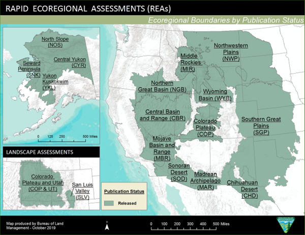
The REAs are now completed, and two (Colorado Plateau, Northern Great Basin) have been updated or expanded. The REAs led to many positive outcomes; for example, development of the Landscape Approach Data Portal increased use of landscape perspectives by BLM staff in their decision making. However, not all aspects of the REAs were as successful as was hoped for at the outset. We are now focused on documenting processes and product use to inform recommendations for the future.
Project Goal and Objectives
This effort is envisioned to take a comprehensive look at BLM’s REA initiative to meet three objectives:
- Document the processes and approaches used to develop the REAs,
- Evaluate how the REAs were used in subsequent land use plans, and
- Develop recommendations for future landscape-level assessments that can inform planning and management decisions across multiple-use lands.
BLM-USGS Science-Management Partnership
USGS and BLM are working together as partners to coproduce this project, with a goal of producing practical, actionable science that informs planning, policy and management decisions on public lands managed by the BLM (see BLM’s Coproduction Toolkit for more information on coproduction).
Landscape assessments have been proposed as a mechanism for informing conservation and natural resource management actions at broad scales. We are documenting the process used in a large effort to conduct 14 such assessments across the western United States, and evaluating how the assessments were used in subsequent land use plans. In this project, we seek to identify methods and characteristics that correspond with increased use of these landscape assessments.
BLM began a major initiative more than a decade ago to conduct a series of Rapid Ecoregional Assessments (REAs) across the western U.S., including in Alaska. BLM’s approach to this large initiative was pointedly experimental: different REAs used different approaches, models, and indicators to answer different management questions. A key component of the overall REA effort was envisioned to be an assessment of how the different approaches worked, resulting in recommendations for conducting future landscape-level assessments that achieve the goal of being useful for - and used to - inform planning and management decisions on multiple-use public lands.
The REAs are now completed, and two (Colorado Plateau, Northern Great Basin) have been updated or expanded. The REAs led to many positive outcomes; for example, development of the Landscape Approach Data Portal increased use of landscape perspectives by BLM staff in their decision making. However, not all aspects of the REAs were as successful as was hoped for at the outset. We are now focused on documenting processes and product use to inform recommendations for the future.
Project Goal and Objectives
This effort is envisioned to take a comprehensive look at BLM’s REA initiative to meet three objectives:
- Document the processes and approaches used to develop the REAs,
- Evaluate how the REAs were used in subsequent land use plans, and
- Develop recommendations for future landscape-level assessments that can inform planning and management decisions across multiple-use lands.
BLM-USGS Science-Management Partnership
USGS and BLM are working together as partners to coproduce this project, with a goal of producing practical, actionable science that informs planning, policy and management decisions on public lands managed by the BLM (see BLM’s Coproduction Toolkit for more information on coproduction).