



Towards an integrated multi-scale understanding of dryland plant traits with application to land management
This proposed project brings together scientists, federal agencies, and land managers to improve the monitoring and management of dryland ecosystems in the western United States.
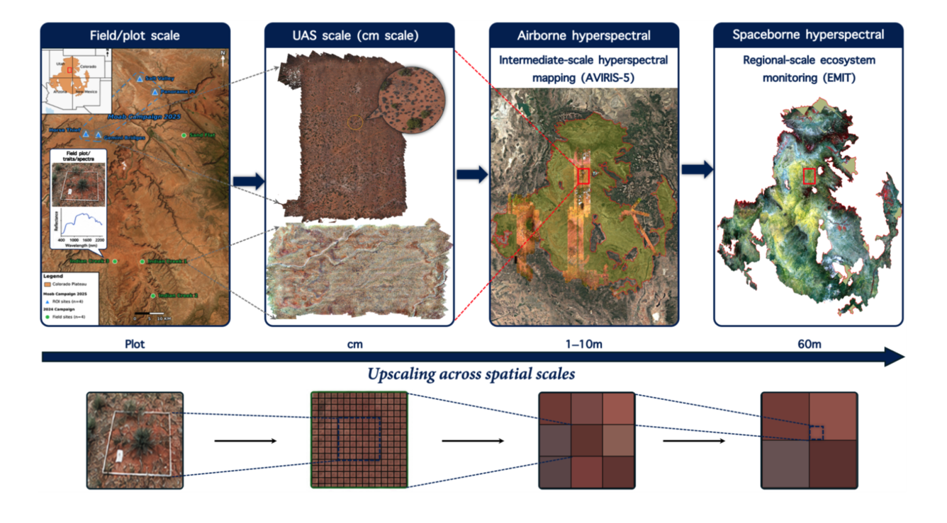
This proposed project brings together scientists, federal agencies, and land managers to improve the monitoring and management of dryland ecosystems in the western United States. The team plans to combine airborne hyperspectral imagery, satellite observations, field measurements, and artificial intelligence tools to create detailed maps of plant health, forage quality, and invasive species across dryland regions. These ecosystems are critical for food production, water resources, biodiversity, and climate resilience, but they are increasingly threatened by drought, heat, wildfire, land-use change, and invasive plants.
Over a two-year period, the working group will develop new methods for integrating large environmental datasets to produce high-resolution, frequently updated information that can support real-world land management decisions. This includes a synthesis of USGS Geological Earth Mapping Experiment (GEMx) hyperspectral aircraft measurements as well as NEON (National Ecological Observatory Network) joint field and aircraft measurements conducted throughout the western U.S. Expected outcomes include improved tools for monitoring rangeland health, early detection of invasive species, better assessments of wildfire and drought risk, and new scientific products that can help agencies such as the U.S. Department of Agriculture, the Bureau of Land Management, and the Department of the Interior manage drylands more effectively. This is especially critical with gradually drying conditions, more variable rainfall, and more intense droughts in the western United States.
Principal Investigators
Lixin Wang (Indiana University)
Raymond Kokaly (U.S. Geological Survey)
Andrew Feldman (NASA Goddard Space Flight Center/University of Maryland)
William Smith (The University of Arizona)
This proposed project brings together scientists, federal agencies, and land managers to improve the monitoring and management of dryland ecosystems in the western United States.
This proposed project brings together scientists, federal agencies, and land managers to improve the monitoring and management of dryland ecosystems in the western United States. The team plans to combine airborne hyperspectral imagery, satellite observations, field measurements, and artificial intelligence tools to create detailed maps of plant health, forage quality, and invasive species across dryland regions. These ecosystems are critical for food production, water resources, biodiversity, and climate resilience, but they are increasingly threatened by drought, heat, wildfire, land-use change, and invasive plants.
Over a two-year period, the working group will develop new methods for integrating large environmental datasets to produce high-resolution, frequently updated information that can support real-world land management decisions. This includes a synthesis of USGS Geological Earth Mapping Experiment (GEMx) hyperspectral aircraft measurements as well as NEON (National Ecological Observatory Network) joint field and aircraft measurements conducted throughout the western U.S. Expected outcomes include improved tools for monitoring rangeland health, early detection of invasive species, better assessments of wildfire and drought risk, and new scientific products that can help agencies such as the U.S. Department of Agriculture, the Bureau of Land Management, and the Department of the Interior manage drylands more effectively. This is especially critical with gradually drying conditions, more variable rainfall, and more intense droughts in the western United States.
Principal Investigators
Lixin Wang (Indiana University)
Raymond Kokaly (U.S. Geological Survey)
Andrew Feldman (NASA Goddard Space Flight Center/University of Maryland)
William Smith (The University of Arizona)