
Cumberland Gap Study: Sediment Acquisition and Modeling of Davis Branch
Beaver Dam on Davis Branch
Cumberland National Historic Park
Davis Branch, a stream within the boundaries of Cumberland Gap National Historical Park, is a designated Warm Water Aquatic Habitat, Primary Contact Recreation, and Outstanding State Resource Water. Historically, the stream has provided a critical habitat to the federally-threatened Blackside Dace, a small cyprinid fish endemic to the upper Cumberland River basin. In recent decades, the populations of the Blackside Dace have declined throughout the Cumberland River basin due to loss of habitat, stream corridor degradation, and water-quality changes as a consequence of beaver dams within the watershed.
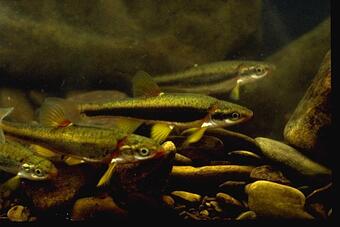
USGS scientists are working with the National Park Service and the University of Kentucky to assess stream conditions in the Davis Branch. Davis Branch, a stream within the boundaries of Cumberland Gap National Historical Park, has provided a critical habitat to the federally-threatened Blackside Dace, a small, native freshwater fish from the minnow family.
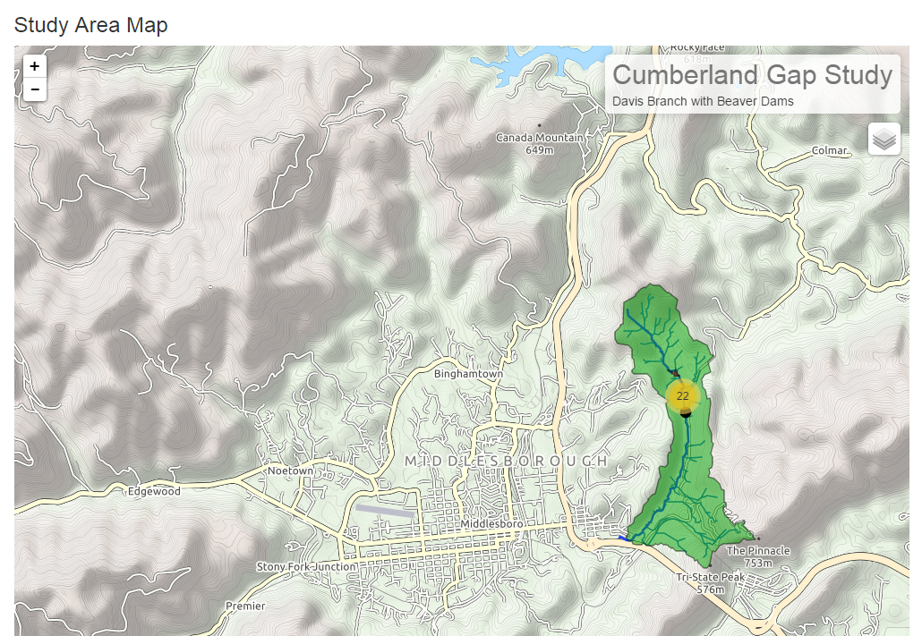
Davis Branch has been classified by U.S. Fish and Wildlife Service as a critical stream to the continued existence of the Blackside Dace. The National Park Service Organic Act and the Endangered Species Act are requiring resource managers at the Cumberland Gap National Historical Park (CUGA) to take actions needed to mitigate the potential loss of the federally threatened species.
USGS Streamgage Data
A USGS streamgage, USGS Station 03401385 Davis Branch At Highway 988 Near Middlesboro, KY, is located on Davis Branch and measures a number of water parameters ranging from water flow, water height, and water quality. The USGS streamgage on Davis Branch has approximately a 2 year period of record (June 2013 - October 2015). These measured parameters help show past and current conditions on Davis Branch. The measurements can be to used to assess the stream conditions in terms of proper habitat for the blackside dace.
Parameters Collected
- Discharge (cubic feet per second)
- Gage height (feet)
- Temperature (degrees Celsius)
- Dissolved oxygen (milligrams per liter)
- pH (standard units)
- Specific conductance (microsiemens per centimeter at 25 degrees Celsius)
- Turbidity (formazin nephelometric units (FNU))
Project Objectives
- Collect sufficient baseline data about sediment loads in Davis Branch.
- Create a numerical modeling tool to help predict streamflow, sediment deposition and transport variability in Davis Branch under existing conditions and during and after the implementation of to-be determined stream restoration measures.
- Provide field and modeled data needed to aid NPS resource managers to prepare an environmental assessment (ESA), plan stream restoration measures, and better assess the potential effectiveness of those restoration measures, thereby better ensuring that habitat conditions are suitable for the re-population and long-term success of Blackside Dace in Davis Branch.
Davis Branch, a stream within the boundaries of Cumberland Gap National Historical Park, is a designated Warm Water Aquatic Habitat, Primary Contact Recreation, and Outstanding State Resource Water. Historically, the stream has provided a critical habitat to the federally-threatened Blackside Dace, a small cyprinid fish endemic to the upper Cumberland River basin. In recent decades, the populations of the Blackside Dace have declined throughout the Cumberland River basin due to loss of habitat, stream corridor degradation, and water-quality changes as a consequence of beaver dams within the watershed.
USGS scientists are working with the National Park Service and the University of Kentucky to assess stream conditions in the Davis Branch. Davis Branch, a stream within the boundaries of Cumberland Gap National Historical Park, has provided a critical habitat to the federally-threatened Blackside Dace, a small, native freshwater fish from the minnow family.
Davis Branch has been classified by U.S. Fish and Wildlife Service as a critical stream to the continued existence of the Blackside Dace. The National Park Service Organic Act and the Endangered Species Act are requiring resource managers at the Cumberland Gap National Historical Park (CUGA) to take actions needed to mitigate the potential loss of the federally threatened species.
USGS Streamgage Data
A USGS streamgage, USGS Station 03401385 Davis Branch At Highway 988 Near Middlesboro, KY, is located on Davis Branch and measures a number of water parameters ranging from water flow, water height, and water quality. The USGS streamgage on Davis Branch has approximately a 2 year period of record (June 2013 - October 2015). These measured parameters help show past and current conditions on Davis Branch. The measurements can be to used to assess the stream conditions in terms of proper habitat for the blackside dace.
Parameters Collected
- Discharge (cubic feet per second)
- Gage height (feet)
- Temperature (degrees Celsius)
- Dissolved oxygen (milligrams per liter)
- pH (standard units)
- Specific conductance (microsiemens per centimeter at 25 degrees Celsius)
- Turbidity (formazin nephelometric units (FNU))
Project Objectives
- Collect sufficient baseline data about sediment loads in Davis Branch.
- Create a numerical modeling tool to help predict streamflow, sediment deposition and transport variability in Davis Branch under existing conditions and during and after the implementation of to-be determined stream restoration measures.
- Provide field and modeled data needed to aid NPS resource managers to prepare an environmental assessment (ESA), plan stream restoration measures, and better assess the potential effectiveness of those restoration measures, thereby better ensuring that habitat conditions are suitable for the re-population and long-term success of Blackside Dace in Davis Branch.