
Apalachicola-Chattahoochee-Flint (ACF) River National Water Quality Assessment (NAWQA) Program Study
In 1991, the Apalachicola-Chattahoochee-Flint (ACF) River basin was selected for investigation in the NAWQA Program. The watershed boundary of the ACF River basin defines an ecosystem in which the quality of the water is a result of the complex interaction of natural and human influences on land and water resources.
Home
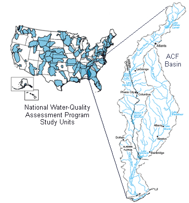
The Apalachicola-Chattahoochee-Flint (ACF) River basin, located in the southeastern United States (fig. 1), was among the first 20 NAWQA study units selected for study in 1991 (Wangsness and Frick, 1991). The ACF River basin drains about 19,800 mi2 in western Georgia, eastern Alabama, and the Florida panhandle, and is comprised of the Chattahoochee and Flint Rivers that converge at Lake Seminole to form the Apalachicola River. The Apalachicola River flows south through the Florida panhandle into Apalachicola Bay, which discharges into the Gulf of Mexico. Basin hydrology is influenced by 16 reservoirs that cause about 50 percent of the mainstem river miles to be in backwater, and play a major role in controlling flow and influencing the quality of water in the basin. The basin is underlain by five major aquifer systems; crystalline rock aquifers in the Blue Ridge and Piedmont physiographic provinces in the northern part of the basin, and four aquifers in the Coastal Plain physiographic province in the southern part of the basin. For more detailed information on the environmental setting of the ACF River basin, see Couch and others (1996).
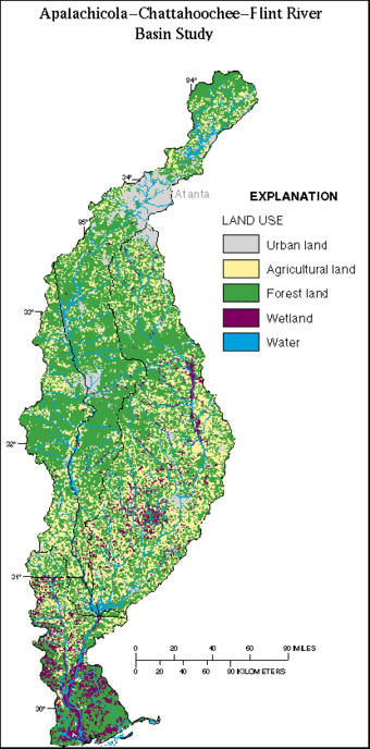
The goal of the ACF River basin study design is to compare and contrast the effects of predominant land uses on surface- and ground-water quality. Forest and agriculture are dominant land uses and land covers within the ACF River basin, accounting for 59 and 29 percent of the study area, respectively. Most agricultural land in the upper and middle Chattahoochee and upper Flint River subbasins is used for livestock grazing and poultry production, while most agricultural land in the southern ACF River basin is used for row crops and vegetables; and to a lesser extent, orchards. Urban land use accounts for 5.3 percent of the study area. In 1990, the population of the ACF River basin was about 2.64 million people, 60 percent of which lived in the Metropolitan Atlanta area. Wetland areas account for about 5.4 percent of the entire basin. Agricultural and urban land uses are of particular interest within the ACF River basin, because they have the greatest potential impact on the physical, chemical, and biological quality of the surface- and ground-water resources.
The National Water Quality Assessment Program
The National Water-Quality Assessment Program (NAWQA) provides an understanding of water-quality conditions; whether conditions are getting better or worse over time; and how natural features and human activities affect those conditions. Regional and national assessments are possible because of a consistent study design and uniform methods of data collection and analysis. Monitoring data are integrated with geographic information on hydrological characteristics, land use, and other landscape features in models to extend water-quality understanding to unmonitored areas. Local, State, Tribal, and national stakeholders use NAWQA information to design and implement strategies for managing, protecting, and monitoring water resources in many different hydrologic and land-use settings across the Nation.
The USGS implemented the National Water-Quality Assessment (NAWQA) Program in 1991 to develop long-term consistent and comparable information on streams, rivers, ground water, and aquatic systems in support of national, regional, State, and local information needs and decisions related to water-quality management and policy. The NAWQA program is designed to address the following objectives and answer these questions:
- What is the condition of our Nation's streams, rivers, and ground water?
- How are these conditions changing over time?
- How do natural features and human activities affect these conditions, and where are those effects most pronounced?
USGS scientists collect and interpret data about surface- and ground-water chemistry, hydrology, land use, stream habitat, and aquatic life in parts or all of nearly all 50 States using a nationally consistent study design and uniform methods of sampling analysis (access NAWQA protocols).
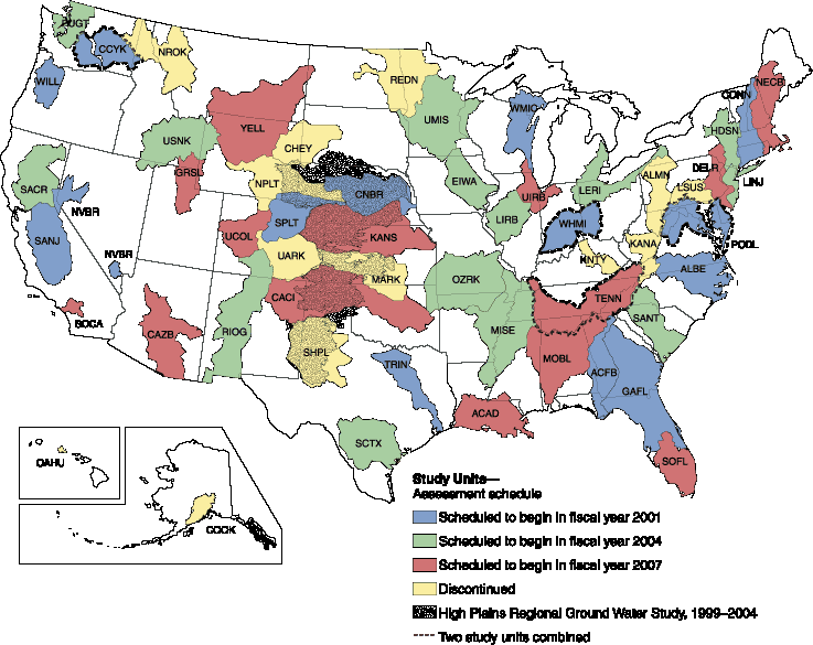
From 1991-2001, the NAWQA Program conducted interdisciplinary assessments and established a baseline understanding of water-quality conditions in 51 of the Nation's river basins and aquifers, referred to as Study Units. Descriptions of water-quality conditions in streams and ground water were developed in more than a thousand reports (access NAWQA publications). Non-technical Summary Reports, written primarily for those interested or involved in resource management, conservation, regulation, and policymaking, were completed for each of the 51 Study Units. Non-technical national summary reports on pesticides, nutrients, and volatile organic compounds (VOCs) also were completed, in which water-quality conditions were compared to national standards and guidelines related to drinking water, protection of aquatic life, and nutrient enrichment.
NAWQA activities during the second decade (2001-2012) focus in large part on national and regional assessments, all of which build on continued monitoring and assessments in 42 of the 51 Study Units completed in the first cycle (USGS Fact Sheet 071-01).
Selected major activities during the second decade include:
- Studies on five national priority topics including on the fate of agricultural chemicals, effects of urbanization on stream ecosystems, bioaccumulation of mercury in stream ecosystems, effects of nutrient enrichment on aquatic ecosystems, and transport of contaminants to public-supply wells.
- Regional assessments of water-quality and trends in surface water and principal aquifers, which encompass larger regions of the country than the Study Units.
- National assessments of source water and drinking water associated with domestic wells, and with drinking-water supply wells, stream intakes, and finished water associated with community water systems across the Nation.
NAWQA is planning activities for its third decade (2013-2023) (access a summary of the Program's progress through 2008 and setting the stage for the future).
Basin Description:
Description of the Apalachicola-Chattahoochee-Flint River Basin Study Area
The purposes of this report are to describe the environmental setting and the influence of this setting on aquatic ecosystems of the ACF River basin. The environmental setting includes physical, biological, and cultural characteristics of the ACF River basin. The physical setting includes physiographic, soil, climatic, and hydrologic factors. The biological setting summarizes historical and current (1992) information on habitats and aquatic biota within the basin. The cultural setting describes how the human population uses land and water resources within the basin.
Available literature and reports from Federal, State, and local agencies are used to describe the environmental setting of the ACF River basin. Whereas many of these reports deal with topics of limited scope and geographic extent, it is the objective of this report to provide a broad synthesis of topics relevant to understanding determinants of the health of the aquatic ecosystem and water-quality conditions in the ACF River basin.
Although the basinwide scope of NAWQA's ACF River basin study is unprecedented, water-quality assessments of regional scope have been conducted previously in parts of the basin. The USGS conducted two earlier regional water-quality studies, one in the Apalachicola River basin (Elder and others, 1988), and another in the upper Chattahoochee River basin (Cherry and others, 1980).
In 1971, the Georgia Water Quality Control Board (predecessor to the Georgia Department of Natural Resources, Environmental Protection Division) published a water-quality assessment of the Chattahoochee River from its headwaters to Lake Seminole, and an assessment of the Flint River from Fulton County to near Griffin, Ga., (Georgia Water Quality Control Board, 1971a,b). Another water-quality study of regional scope was conducted on West Point Lake by the USGS for the U.S. Army Corps of Engineers (USACOE) (Radtke and others, 1984).
Text extracted from Couch and others 1995.
Location
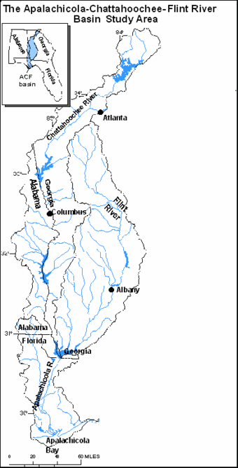
The ACF River basin NAWQA study area is about 20,400 sq mi This number includes the drainage area at the mouth of the Apalachicola River (19,600 sq mi) (U.S. Army Corps of Engineers, 1985); the New River watershed (about 510 sq. mi.) (U.S. Geological Survey digital files); and the Apalachicola Bay and surrounding coastal areas and barrier islands (about 270 sq. mi.) (U.S. Geological Survey digital files). The Chattahoochee and Flint Rivers merge in Lake Seminole to form the Apalachicola River, which flows through the panhandle of Florida into the Apalachicola Bay, and discharges into the Gulf of Mexico.
Near West Point Lake, the Chattahoochee River defines the state boundaries between Alabama and Georgia. The Flint River basin is contained entirely within Georgia. Except for the upper reaches of the Chipola River in Alabama, the Apalachicola River basin is contained within the panhandle of Florida.
Text extracted from Couch and others 1995.
Physiography
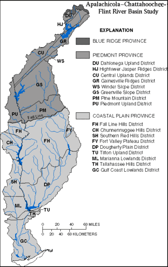
The ACF River basin contains parts of the Physiographic Provinces of the Apalachicola-Chattahoochee-Flint River Basin that extend throughout the southeastern United States. Similar to much of the Southeast, the basin's physiography reflects a geologic history of mountain building in the Appalachian Mountains, and long periods of repeated land submergence in the Coastal Plain Province. Glaciers, which influenced the physiography of much of North America, never extended to the southeastern United States. Physiography within the major provinces is not homogeneous and has been subdivided by the States of Alabama, Florida, and Georgia into the districts shown on the Physiographic Province Map. Although similar physiography may extend across state boundaries, districts may be assigned different names by state geologists in each state.
The northernmost part of the ACF River basin is within the Blue Ridge Province where headwaters of the Chattahoochee River arise. Less than one percent of the basin lies within the Blue Ridge Province. The Blue Ridge Province is dominated by rugged mountains and ridges that range in altitude from 3,000 to 3,500 feet (ft). The boundary between the Blue Ridge and the Piedmont is defined by a sharp change in slope at an altitude of approximately 1,700 ft. The Blue Ridge and Piedmont Provinces are underlain by mostly Precambrian and older Paleozoic crystalline rocks that include mica schist, felsic gneiss and schist, and granite and granite gneiss. Less extensive outcrops of quartzites are also present.
The part of the ACF River basin within the Piedmont Province in Georgia contains parts of seven physiographic districts-the Dahlonega Upland, the Hightower-Jasper Ridges, the Central Uplands, the Gainesville Ridges, Winder Slope, the Greenville Slope, and the Pine Mountain Districts (Clark and Zisa, 1976). In the Piedmont Province within Alabama, the ACF River basin lies in the Piedmont Upland District (Copeland, 1968).
The northeast trending linear-ridge structure of the Hightower-Jasper Ridges, the Central Uplands and Gainesville Ridges Districts strongly control the course of the upper Chattahoochee River and its tributaries. In particular, highly fractured faults in the Gainesville Ridges District forces the Chattahoochee River and its tributaries into a rectangular drainage pattern. Within these three ridge districts, altitudes range from about 1,500 ft in the northeast and to about 1,000 ft in the southwest. Relief, the distance between minimum and maximum altitudes, varies from approximately 500 ft in the northeast to 100-200 ft in the southwest (Clark and Zisa, 1976).
The Greenville Slope District in Georgia and the Piedmont Upland District in Alabama are both characterized by rolling topography with altitudes ranging from 1,000 ft in the Greenville Slope to 500-800 ft in the Piedmont Upland (Clark and Zisa, 1976; Copeland, 1968). Streams occupy broad, shallow valleys separated by broad, rounded divides and have dendritic drainage patterns.
The Pine Mountain District in Georgia rises abruptly from the Greenville Slope District to altitudes of 1,200-1,300 feet. The Pine Mountain District is dominated by Pine Oak Mountain, which is capped by quartzite. This district is notable for the presence of natural, warm-water springs flowing from fractured quartzite. Watersheds on the southern face of this west-to-east trending mountain ridge have rectangular drainage patterns (Clark and Zisa, 1976).
The Fall Line is the boundary between the Piedmont and Coastal Plain Provinces. This boundary approximately follows the contact between crystalline rocks of the Piedmont Province and the unconsolidated Cretaceous and Tertiary sediments of the Coastal Plain Province. As implied by the name, streams flowing across the Fall Line can undergo abrupt changes in gradient which are marked by the presence of rapids and shoals. Geomorphic characteristics of streams differ between the Piedmont and Coastal Plain Provinces. In the Coastal Plain, streams typically lack the riffles and shoals common to streams in the Piedmont, and exhibit greater floodplain development and increased sinuosity (Wharton, 1978).
The Coastal Plain Province contains three distinct regions-a hilly region immediately below the Fall Line; a region of karst topography; and a low-lying coastal region. The Fall Line Hills District in Georgia and Alabama, and the Chunnennuggee and Southern Red Hills Districts in Alabama are highly dissected with relief ranging 50-250 ft. Cretaceous sediments lie in a band immediately below the Fall Line and crop out into younger Eocene-Paleocene sediments of the low-lying Dougherty Plain District.
The Dougherty Plain and the Mariana Lowlands Districts are characterized by outcrops of the Ocala and Suwannee Limestones that result in a karst topography. The Dougherty Plain slopes southwestward with altitudes of 300 ft in the northeast to less than 100 ft near Lake Seminole. The flat to very gently rolling topography contains numerous sinkholes and associated marshes and ponds. Small streams in the Dougherty Plain District are frequently intermittent during the summer. The eastern boundary of the ACF River basin includes a small portion of the Tifton Upland District where the boundary with the Dougherty Plain is defined by the steeply sloping Pelham Escarpment. This solution escarpment continues to the northeast, forming the surface-water divide between the Flint River basin and the Ochlockonee River basin to the east.
A detailed description of physiography in the Apalachicola River basin is contained in Leitman and others (1983). The upper part of the basin lies within the Tallahassee Hills, Grand Ridge, New Hope Ridge, and Marianna Lowlands Districts. As it flows through the Tallahassee Hills District, the Apalachicola River is bordered on the east side by steep bluffs. The Tallahassee Hills District has altitudes as high as 325 ft, and is bounded on the south by the Cody Scarp, where elevations drop 15 to 20 ft to the Gulf Coast Lowlands. The Marianna Lowlands is a karst plain drained by the Chipola River, the largest tributary within the Apalachicola River basin.
The Gulf Coast Lowlands lie south of the Tallahassee Hills, Grand Ridge and New Hope Ridge Districts and extend to the Gulf of Mexico. This flat, sandy lowland was shaped by waves and currents during inundation by Pleistocene seas. This district is less than 100 ft in elevation. As the Apalachicola River flows southward through the Gulf Coast Lowlands, its floodplain broadens in width from 3 to 5 miles (mi).
Text extracted from Couch and others 1995.
Soils
Three major soil orders-ultisols, entisols, and spodosols, and more than 50 soil series-are present in the ACF River basin (Hajek and others, 1975; Perkins and Shaffer, 1977; Caldwell and Johnson, 1982). Ultisols are characterized by sandy or loamy surface horizons and loamy or clayey subsurface horizons. These deeply weathered soils are derived from underlying acid crystalline and metamorphic rock. Entisols are young soils with little or no change from parent material and with poorly developed subhorizons. These soils are frequently infertile and droughty because they are deep, sandy, well-drained, and subject to active erosion. Spodosols are characterized by a thin sandy subhorizon underlaying the A horizon. This sandy subhorizon is cemented by organic matter and aluminum. The ACF River basin is similar to much of the southeastern coastal plain in the dominance of ultisols. Entisols are found at and below the Fall Line and in the Dougherty Plain; and spodosols are found in the Gulf Coast Lowlands.
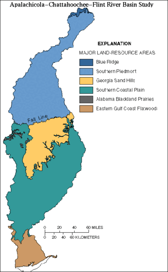
Soils of the ACF River basin are divided into six major land-resource areas (10K) (formerly called soil provinces). The Southern Piedmont, Georgia Sand Hills, Southern Coastal Plain, and Eastern Gulf Coast Flatwoods land-resource areas cover 97 percent of the ACF River basin. The Southern Piedmont land-resource area is dominated by ultisols. Piedmont ultisol soils are acid, low in nitrogen and phosphorus, and generally lack the original topsoil. Topsoil erosion began with intensive cultivation of cotton in the 1800's (Wharton, 1978).
Soils in the Southern Coastal Plain and the Georgia Sand Hills land-resource areas are derived from marine and fluvial sediments eroded from the Appalachian and Piedmont Plateaus. Ultisols are found throughout the Southern Coastal Plain, with the exception of some areas in the Georgia Sand Hills and Dougherty Plain where entisols locally are present.
The Eastern Gulf Coast Flatwoods land-resource area, which composes much of the Apalachicola River basin, is dominated by spodosols. Spodosols of the low-lying Eastern Gulf Coast Flatwoods are poorly-to-very poorly drained.
Basinwide patterns in soil leaching and runoff potential provide information on areas that may be susceptible to greater contaminant transport through infiltration or runoff. Soils with high leaching rates are concentrated in the sandy Cretaceous sediments below the Fall Line and in the sandy surficial sediments of the East Gulf Coast Flatwoods.
Runoff ratings are based on the inherent capacity of bare soil to permit infiltration, and consider slope, frequency of flooding during the growing season, and permeability (Brown and others, 1991). Soils with high runoff ratings are distributed throughout the basin, but are concentrated in areas having low permeability, steep slopes; or where flooding is frequent or the water table is near the surface, such as in floodplains and other low-lying areas. In the ACF River basin, soils with the highest runoff rate are present on steep slopes in the Blue Ridge, several areas in the Piedmont Province, the Fall Line Hills District, and in the lower Apalachicola River basin where soils commonly remain saturated.
Text extracted from Couch and others 1995.
Climate
The ACF River basin is characterized by a warm and humid, temperate climate. Major factors influencing climate variability in the basin are latitude, altitude, and proximity to the Gulf of Mexico.
Because the ACF River basin spans about 5 degrees of latitude, it has a sharp gradient in growing seasons. Average annual temperature ranges from about 60 °F in the north to 70 °F in the south. Average daily temperatures in the basin for January range from about 40 °F to 55 °F, and for July from 75 °F to 80°F. In the winter, cold winds from the northwest cause the minimum temperature to dip below freezing for only short periods. Summer temperatures commonly range from the 70's to the 90's.
Precipitation is greatest either in the mountains as a result of their orographic effect or near the Gulf of Mexico as a result of the availability of moist air. Average annual precipitation in the basin, primarily as rainfall, is about 55 inches (in.), but ranges from a low of 45 in. in the east-central part of the basin to a high of 60 in. in the Florida panhandle (U.S. Geological Survey, 1986).
Evapotranspiration generally increases from north to south and ranges from about 32 to 42 in. per year. In the east-central part of the basin, precipitation and evapotranspiration are about equal. Average annual runoff ranges from 15 to 40 in. Runoff is greatest in the Blue Ridge Mountains and near the Gulf coast (Gebert and others, 1987).
Text extracted from Couch and others 1995.
Surface-Water Hydrology
The Chattahoochee and Flint River basins in Georgia contain most of the headwater watersheds for surface waters that flow into or are used by the Florida and Alabama parts of the basin. This section describes the hydrology of the Chattahoochee, Flint, and Apalachicola River basins. Throughout the ACF River basin, low flows usually occur from September to November and peak flows usually occur from January to April when rainfall is high and evapotranspiration is low.
Chattahoochee River Basin
The Chattahoochee River-whose name is derived from Creek Indian words meaning painted rock-drains an area of 8,770 sq mi and is the most heavily used water resource in Georgia. The Chattahoochee River arises as a cold-water mountain stream in the Blue Ridge Province at altitudes above 3,000 ft and flows 430 mi to its confluence with the Flint River. The discharge of the Chattahoochee River based on median daily flows near Columbia, Ala., during water years 1977-92 was 8,250 cubic feet per second (cfs). Median daily discharge ranged from a low of 498 cfs in 1989 to a high of 191,000 cfs in 1990.
Thirteen of 16 dams on mainstem locations in the ACF River basin are on the Chattahoochee River. Dam construction in the basin began in the early 1800's on the Chattahoochee River above the Fall Line at Columbus, Ga., to take advantage of natural gradients for power production. Annual flow has not been appreciably altered by the system of dams, although storage is used to augment flows during periods of low flow; and daily fluctuations below some reservoirs can be dramatic. Pronounced decreases in the frequency of high and low flows have occurred since the start of operation of Buford Dam that forms Lake Sidney Lanier. Lake Sidney Lanier, West Point Lake, and Lake Walter F. George provide most water storage available to regulate flows in the basin. Lake Sidney Lanier alone provides 65 percent of conservation storage, although it drains only 5 percent of the ACF River basin. In addition, West Point Lake and Lake Walter F. George provide 18 and 14 percent, respectively, of the basin's conservation storage (Leitman and others, 1991).
Over most of its length, the flow of the Chattahoochee River is controlled by hydroelectric plants releasing water for production of hydropower. These hydroelectric plants use hydropeaking operations to augment power supply during peak periods of electric demand. At Cornelia, Ga., the Chattahoochee River is free flowing; however, throughout the remainder of its length, the river's hydrograph shows the influence of hydropeaking operation. Hydropeaking operations can result in daily stage fluctuations of 4 ft or more.
In contrast to the mainstem Chattahoochee River, many tributaries remain free flowing. Flows of tributaries in forested basins are represented by Snake Creek that drains 35.5 sq mi above streamflow-gaging station 02337500. Flows typical of urban basins are represented by Peachtree Creek. Above streamflow-gaging station 02336300, Peachtree Creek drains a 86.8 sq mi urban basin in Metropolitan Atlanta. Similar to most Piedmont streams, both streams have higher sustained flows during winter months, and show responses to storm events throughout the year. However, sharper peaks in the hydrograph of Peachtree Creek reflect the greater influence of impervious land cover in this urban basin.
Flint River Basin
The Flint River is about 350 miles long and drains an area of 8,460 sq. mi. Most of the larger tributaries in the ACF River basin are located in the Coastal Plain Province part of the Flint River basin. These tributaries-with their Creek Indian meaning in parentheses-include Ichawaynochaway Creek (buck sleeping place), Chickasawhatchee Creek (council house creek), Kinchafoonee Creek (mortar bone or pounding block creek), and Muckalee Creek (pour-upon-me creek) (Utley and Hemperley, 1975).
Spring Creek, formerly a Flint River tributary that now discharges directly into Lake Seminole, drains 585 sq mi in a region of karst topography. As implied by its name, flow in Spring Creek is dominated by ground-water discharge directly into its limestone bed.
From 1977-92, the discharge of the Flint River based on mean daily flows at Newton, Ga., was 4,030 cfs. Mean daily discharge ranged from 922 cfs in 1991 to 47,000 cfs in 1990. Two hydropower dams located on the Flint River impound run-of-the-river reservoirs and do not appreciably influence the flow of the Flint River. The Flint River has one of only 42 free-flowing river reaches longer than 125 mi remaining in the contiguous 48 states (Benke, 1990).
Higher flows during winter months are evident in the annual hydrographs of the Flint River, Ichawaynochaway Creek, and Spring Creek. During winter months, Coastal Plain streams, such as Ichawaynochaway and Spring Creeks, flow for sustained periods through their floodplains.
Apalachicola River Basin
The Apalachicola River flows unimpeded for 106 mi from Jim Woodruff Lock and Dam to the Gulf of Mexico. The river drains about 2,600 sq mi and its shallow estuary covers about 208 sq mi. Tidal influences do not extend beyond 25 mi upstream from the river's mouth. The Apalachicola River falls 40 ft as it flows through the Gulf Coast Lowlands. The width of the river ranges from several hundred feet when confined to its banks to nearly 4-1/2 mi during high flows. The discharge of the Apalachicola River is 21st in magnitude among the rivers of the conterminous United States, and is the largest in Florida, accounting for 35 percent of freshwater flow on the western coast of Florida (Livingston, 1992). During 1977-92, the discharge of the Apalachicola River based on mean daily discharge at Sumatra, Fla., was 19,602 cfs. Mean daily discharge at Sumatra ranged from 5,800 cfs in 1981 to 178,000 cfs in 1990. Eighty percent of the Apalachicola River flow is contributed by the Chattahoochee and Flint Rivers, 11 percent from the Chipola River, and less than 10 percent from ground water and overland flow (Elder and others, 1988). The Chipola River-Apalachicola River's largest tributary-drains one-half of the Apalachicola River basin. The Chipola River is classified as a spring-fed river with baseflow derived principally from aquifers.
Because of rainfall-distribution patterns, the average annual runoff from the Chattahoochee River exceeds that of the Flint River. The Chattahoochee River makes a greater contribution to peak flows in the Apalachicola River than the Flint River. However, during extreme dry periods, the greater flow contribution in the Apalachicola River comes from the Flint River, where baseflow is sustained by ground-water discharges (Elder and others, 1988).
Leitman and others (1983) studied stage and discharge records from 1929-79 to determine if significant hydrologic changes occurred in the Apalachicola River as a result of dam-flow regulation. Dams have had little effect on the magnitude of high flows or seasonal distribution of discharge over an annual cycle. Dam regulation did reduce the amount of time that flow was at low extremes. Water stages in the river within the first 30 mi downstream of Jim Woodruff Lock and Dam have lowered due to scouring of the river bottom.
Text extracted from Couch and others 1995.
Groundwater Hydrology
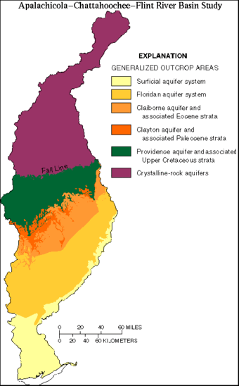
Six major aquifers underlie the ACF River basin. These aquifers, listed in descending order, are the surficial aquifer system, the Floridan aquifer system, the Claiborne aquifer, the Clayton aquifer, the Providence aquifer, and the crystalline rock aquifer. Generalized outcrop areas and stratigraphy of aquifers underlying the Coastal Plain Province generally are separated by confining units.
Aquifers in the Coastal Plain Province consist of alternating units of sand, clay, sandstone, dolomite, and limestone that dip gently and thicken to the southeast. Confining units between these aquifers are mostly silt and clay. From the Fall Line to the Gulf of Mexico, progressively younger sediments crop out and overlie older sediments. The complex interbedded clastic rocks and sediments of Coastal Plain aquifers range in age from Quaternary to Cretaceous. Because of gradational changes in hydrologic properties, aquifer and stratigraphic boundaries are not always coincident.
The surficial aquifer system is a shallow, mostly unconfined water-table aquifer consisting of cross-bedded sand, gravel and clay with undifferentiated alluvium near rivers. Surficial deposits are associated with all outcrop areas shown on the Generalized Outcrop map. However, only in the southern part of the ACF River basin do these deposits contain ground water whose use warrants mapping as a single aquifer (Miller, 1990). Isolated domestic wells withdraw water from the surficial aquifer system.
The Floridan aquifer system, one of the most productive aquifers worldwide, underlies about 100,000 sq mi in Florida, southern Alabama, southern Georgia, and southern South Carolina. The Floridan aquifer system comprises of a thick sequence of carbonate rocks that are of Tertiary age and are hydraulically connected in varying degrees (Miller, 1986). The Ocala Limestone is one of the thickest and most productive formations that crops out in the Dougherty Plain and gives rise to a karst topography riddled with sinkholes. The complex hydrogeology of the Floridan aquifer system is reflected by highly variable transmissivities that range from 2,000 to 1,300,000 feet squared per day (sq ft/d). Range in transmissivities in the Ocala Limestone is caused by the variable, fractured nature, and the dissolution of limestone that creates conduits and solution openings (Miller, 1986).
The Tallahatta Formation of Eocene age is the principal water-bearing formation of the Claiborne aquifer (McFadden and Perriello, 1983). The Clayton Formation of Paleocene age is the water-bearing formation of the Clayton aquifer. Cretaceous units crop out immediately below the Fall Line. The principal water-bearing formation is the Providence Sand of Late Cretaceous age (McFadden and Perriello, 1983). Older Cretaceous strata generally are too deep to be economically developed.
Aquifers in the Piedmont and Blue Ridge Provinces are in crystalline rocks that crop out in the northern part of the basin and extend to the Fall Line. These crystalline rocks have similar hydraulic characteristics and are mapped as one aquifer. The metamorphic and igneous crystalline rocks of the crystalline aquifer are overlain by pockets of regolith (weathered, unconsolidated rock debris) of varying thicknesses. The greatest thicknesses of regolith, as much as about 100 ft, are in draws and valleys. Because the crystalline rocks have few primary pore spaces, ground water is obtained primarily from the regolith and from fractures in the rock. Reported yields of wells completed in these rocks range from zero to 471 gallons per minute (gal/m) but are commonly less than 50 gal/m (Cressler and others, 1983; Chapman and others, 1993).
The regional direction of ground-water flow is from north to south; however, local flow directions vary, especially in the vicinity of streams and areas having large ground-water withdrawals. Rivers and streams in the Coastal Plain Province commonly are deeply incised into underlying aquifers and receive substantial amounts of ground-water discharge. Strata associated with the Floridan aquifer system are exposed along sections of the Apalachicola, Chattahoochee, and Flint Rivers; and Spring Creek (Maslia and Hayes, 1988). As a result of the hydraulic connection between the Floridan aquifer system and the Flint River, ground-water discharge contributes more significantly to baseflow in the Flint River than in the Chattahoochee River. Aquifer discharge to the Chattahoochee River is estimated to be one-fifth of the amount that discharges to the Flint River (Torak and others, 1993).
Text extracted from Couch and others 1995.
Study Design
Goals of Study Design
Much of the historical data and current monitoring programs focus on point-source inputs and their effect on mainstem rivers. Since the effects of nonpoint-source inputs from various land uses is poorly understood, the NAWQA Program has been designed to fill that information gap. Because the ACF River basin is too large to allow for the detailed study of each stream and aquifer, several small watersheds and aquifer systems were selected to represent a predominant land use and/or physiographic area. The term predominant land use is used to describe areas of mixed land uses that are dominated by one land-use type (e.g. 60 percent row-crop agriculture and a mix of other land uses), but are not homogeneous (e.g. 100 percent row-crop agriculture). The ideal study design for comparison of land-use effects on water quality is a system of paired watersheds having different, homogeneous land uses. The goal of NAWQA is to describe water quality in large areas of the country, however, large areas of homogeneous land use generally do not exist in the ACF River basin. Therefore, small watersheds with no point-source inputs and having mixed land use, predominated by the target land use and typical of other small watersheds in the area, were selected for study. These small watersheds, ranging from about 18-105 sq mi in area, represent a medium-sized scale of study that provides the link between small-scale studies (ie. farm-field level studies) and large-scale studies (ie. large tributaries and mainstem rivers draining mixed land uses and physiography, and containing point-source inputs). Because the goal of the study is to document water quality and describe the effects of land uses on water quality in the ACF River basin, it is necessary to study effects of land use at a medium scale, address some specific questions at a smaller scale, but ultimately be able to transfer what was learned at those scales to larger areas of the basin. It is this nested study design that will be described in greater detail in the following sections of this report.
During the development of the study design, the goal was to integrate surface-water, ground-water, and biological components where possible so as to be able to document the current water quality of the study area, to begin to describe the effects of predominant land uses on that water quality, and to lay the foundation for future evaluation of the surface- and ground-water resources as an integrated system. The design primarily focuses on nonpoint-source inputs of nutrients, sediment, and pesticides from agricultural, urban, and forested land uses. The primary agricultural land uses of interest are poultry production in the headwaters of the ACF River basin (Piedmont physiographic province) and production of row crops in the southern half of the basin (Coastal Plain physiographic province). The urban land uses of interest are intensive commercial areas, such as downtown Atlanta, and suburban residential areas, such as those surrounding Atlanta. In some parts of the country forested lands represent large undisturbed areas and are suitable for collection of background information. Forested lands in the ACF River basin generally are being managed silviculturally. But even though the forested lands have been, or are being disturbed, they are the best representation of background water-quality conditions, and their effect on water quality is of value for comparison to other land uses.
Text extracted from Wangsness, 1996
Surface-water Sites
The surface-water system of the ACF River basin was stratified based on physiography and major land uses. Water-quality monitoring locations were then chosen to represent predominant land uses at various scales. The monitoring network reflects the nested study design described earlier, starting with a few fixed monitoring sites (integrator sites and indicator sites, a subset of which were intensive monitoring sites), adding a group of comparison sites, and finally a group of sampling sites on large tributaries and main-stem rivers. Water samples were collected at frequencies varying from hourly to annually, depending on the intended purpose. The different monitoring sites, sample types, and sample frequencies are described in the following sections. Site numbers assigned to each location are provided as a cross-reference to the locator maps.
-Integrator Sites
Because there already was an extensive monitoring network in the basin, supported by State and Federal agencies, the NAWQA study design focused on three integrator sites located on mainstem rivers; two on the Chattahoochee River upstream and downstream of Metropolitan Atlanta, and one on the Apalachicola River near the mouth. The first two sites were selected to provide an estimate of total load of selected constituents in the Chattahoochee River upstream and downstream of a major source of point and nonpoint inputs to the river. Extensive monitoring of many point-source discharges to the river and tributaries provide data to estimate point-source loads of selected constituents and, by difference, estimate nonpoint-source loads from tributaries draining Metropolitan Atlanta. The site near the mouth of the Apalachicola River was selected to provide an estimate of total load of selected constituents entering Apalachicola Bay. These data are valuable for comparing current and historical water-quality conditions, for documenting current water-quality conditions, and for analysis of long-term trends in the future.
-Indicator Sites
Six indicator sites located on small streams having drainage areas ranging from about 18-105 sq mi, represent target land uses and physiography. West Fork Little River, the most upstream basin, represents water quality in an area of intensive poultry production. The primary issue is nutrient input from poultry litter that is spread on pastures surrounding the production areas. Sope Creek and Peachtree Creek are located within Metropolitan Atlanta and represent water quality in intensive urban and suburban watersheds, respectively. Sope Creek receives runoff from residential areas, and from suburban commercial areas and transportation networks that are less dense than areas within the City of Atlanta. Peachtree Creek receives runoff from dense commercial areas and transportation networks associated with the City of Atlanta, and inputs from combined sewer overflows (CSOs). Snake Creek receives runoff from an area that is predominantly forested. Tracts of land within the basin have been harvested for pulp and lumber and, therefore, the basin does not represent an unimpacted control watershed. However, since about sixty percent of the ACF River basin is forested, and under some type of silvicultural management, Snake Creek is typical and representative of forested basins within the study unit. Lime Creek and Aycocks Creek represent water quality in areas of intensive row-crop agriculture. Unlike parts of the United States where large, continuous tracts of land often are farmed to the stream bank, farming in the Coastal Plain of the southeastern United States is generally limited to well-drained uplands. This results in smaller and more discontinuous farm fields that do not extend to the river bank. Instead, streams generally are protected from overland runoff by natural buffers consisting of forested wetlands and floodplains. However, the potential remains high for the movement of farm chemicals to streams because the climate and availability of ground water for irrigation are favorable for multi-cropping practices that can result in the application of nutrients and pesticides to fields throughout much of the year.
-Intensive Sites
Sampling sites on Sope, Lime, and Aycocks Creeks were selected as intensive sites and were sampled frequently during a 1-year period to provide temporal data that defines the seasonal distribution of nutrients, sediment, and pesticides. Samples collected nearly once each week and several times during storm hydrographs, provided valuable information on the occurrence, magnitude, and distribution of constituents in the stream system. This information not only helps to assess the water quality of those representative basins, but also can be used to adjust future monitoring programs by targeting specific constituents and key times for conducting intensive sampling.
-Comparison Sites
For each of the six indicator sites 5-6 comparison sites were chosen. Three sites were chosen for between-basin comparison and 2-3 for within-basin comparison. Those sites chosen for between-basin comparison met the same criteria as sites in the indicator basin. In theory, if data collected at all targeted land-use sites during basin-wide synoptic surveys indicated that all basins had very similar water-quality characteristics, then information gained through intensive monitoring of one could be transferred to the others. Within-basin comparison sites were selected to represent inputs from tributaries or sub-basins upstream of the indicator site to help define within-basin variability.
-Synoptic Sites
Monitoring sites were identified near the mouths of major tributaries, upstream and downstream of major reservoirs, and at additional locations on the main-stem rivers. These sites completed the surface-water monitoring network and assured a more complete spatial coverage than the sampling sites described above could provide alone. Synoptic surveys of the entire monitoring network were conducted three times during the period of study (June 1993, March and May 1994). Surveys were conducted during spring and early summer to coincide with periods of nutrient and pesticide applications to urban and agricultural lands.
-Bed Sediment and Tissue
Two bed sediment and tissue surveys were conducted early in the project to provide information useful to the overall study design. An initial survey of 31 sites consisting of integrator, indicator, selected main-stem river, and reservoir sites was conducted in 1992 to determine occurrence of organic compounds and trace metals in bed sediments and the Asiatic clam Corbicula fluminea. A second survey that included resampling of many of the initial sites and 15 additional sites, primarily in urban and suburban watersheds, was conducted in 1993 to better define the distribution of organic compounds and trace metals throughout the ACF River basin. Additional bed sediment samples were collected at 19 sites in September 1994, following the record flooding caused by Tropical Storm Alberto.
Because of the basin-wide distribution of Corbicula fluminea, it was exclusively analyzed to assess the bioaccumulation of organic compounds and trace metals in tissue, except at three locations in the Apalachicola River floodplain where Gambusia affinis holbrooki (mosquitofish) was used for tissue analysis.
-Biological
Biological samples were collected at least once a year at each of the indicator sites and at their respective comparison sites, and a measure of terrestrial and in-stream habitat made once during the period of study. The most intensive sampling effort was conducted at the six indicator sites. A stream reach 6-10 times as long as the average width that contained replicate examples of the various habitats (i.e. pools, riffles, overhangs, submerged logs) was defined. As cross-sectional areas for sampling were identified, care was taken to minimize disturbance of the cross section. Individual quantitative samples of macroinvertebrates and benthic algae were collected from potentially rich habitats such as cobble and gravel substrates in riffles, and depositional areas such as sand and mud in pools. Qualitative samples were collected from these same habitats and, additionally, from other habitats such as the surfaces of living or dead vegetation, root and leaf mats, and overhanging banks in an attempt to provide data on relative abundance, and to better define a complete species list. Fish were collected using techniques such as electroshocking, seines, dip nets, or combinations of these techniques that provided the most representative sample of the fish community. Measurements of in-stream habitat included stream width, depth, and velocity; size and distribution of substrates; amount and type of submerged and emergent vegetation; and estimates of the percent of pools and riffles. Measurements of terrestrial habitat included bank slope and stability; vegetation type, size, and density; and percent of cover overhanging the stream. A less intensive sampling effort was performed at the comparison sites to conserve funds and human resources. Priority was placed on the collection of a representative sample of the fish community; single, qualitative/semiquantitative samples of macroinvertebrates and benthic algae, and measurements of in-stream habitat.
Groundwater Sites
Because few ground-water data existed within the ACF River basin prior to this study, the groundwater monitoring network was designed primarily to provide information on the occurrence and distribution of a large suite of compounds that can be used to better identify problem areas, and define related questions and issues. Data collected during this first cycle of intensive data collection also will provide a valuable reference for comparison with the data collected during subsequent cycles of intensive data collection.
-Study Unit Survey
The study-unit survey was designed to characterize the quality of shallow ground water within the Upper Floridan Aquifer System and to determine the effects of land use. An area of about 3,900 sq mi in the southern part of the study unit, known locally as the Dougherty Plain and Marianna Lowlands, and underlain by the Floridan aquifer system, was selected for the ground-water study-unit survey. The predominant land use in the Dougherty Plain and Marianna Lowlands is row-crop agriculture and orchards. The source of some public and most domestic water supply is the Floridan aquifer system, a highly productive fractured limestone aquifer having karst features. To establish sampling sites within the Dougherty Plain and Marianna Lowlands, the area was subdivided into 30 polygons of similar size and existing wells or, where present, one or two high-flow springs were chosen for sampling from each polygon. Forty two sites were selected for sampling. Depth to water in the monitoring wells ranged from 10-60 ft below land surface (one well was a flowing well with approximately 3 ft of head). Each site was sampled once in August or September 1995. Samples were analyzed for nutrients, pesticides, volatile organic compounds, trace metals, major ions, organic carbon, stable isotopes, and selected radionuclides. On-site measurements of ground-water levels, flow from springs, and field measurements were made at each site.
-Land Use Studies
The agricultural land-use study was designed to determine the chemical quality of shallow ground water that underlies agricultural areas in a 6,700 sq mi area of the southern part of the ACF River basin. Sites for monitoring the surficial aquifer were located randomly using the computer program developed for the NAWQA program (Scott, 1990) and wells were installed according to NAWQA guidelines (Lapham and others, 1995) adjacent to and downgradient of 37 farm fields. Four reference wells were installed in forested areas to represent background water-quality conditions. The depth to the water table in the surficial aquifer monitoring wells ranged from about 3-67 ft below land surface. Surficial aquifers were selected for sampling rather than deeper aquifer systems because surficial aquifers are the first water-bearing zones to receive recharge from infiltration, and presumably are more susceptible to contamination. Therefore, water-quality conditions in surficial aquifers may serve as an early warning of potential contamination of deeper aquifer systems that are used for drinking-water supply and irrigation. Water samples were collected from all wells during summer 1993 and from most wells during spring 1994. The sample times represented low and high water-table conditions, respectively. The samples were analyzed for nutrients, pesticides, volatile organic compounds, major ions, organic carbon, and selected radionuclides. On-site measurements of water levels and field parameters also were made at each site.
The urban land-use study was designed to determine the chemical quality of shallow ground water that underlies Metropolitan Atlanta within a 350 sq mi area of the surficial drainage to the Chattahoochee River. Sampling sites were established by subdividing the study area into 30 polygons of equal area using the computer program developed for NAWQA (Scott, 1990), and then selecting an existing domestic or observation well, and where present, a spring, from each polygon. Forty locations were selected as sampling sites. Depth to water in the monitoring wells ranged from 2-29 ft below land surface. Each site was sampled once during the period from summer 1994 through spring 1995. Samples were analyzed for nutrients, pesticides, volatile organic compounds, major ions, organic carbon, trace metals, and selected radionuclides. On-site measurements of water levels, flows from springs, and field parameters also were made at each site.
-Flow System Studies
The ground-water flow-system study was designed to track the transport of nutrients and pesticides from a field where they were applied, through the shallow flow system that underlies the field and the adjacent forested floodplain/wetland, to areas of discharge to the surface-water system. During previous studies of a 1,000-acre field, nutrients and pesticides were measured in two shallow ground-water monitoring wells adjacent to and down-gradient from the field. Three generalized flow paths were identified within the study area: 1) shallow ground water collected by a network of tile drains within the field that discharged to ditches; 2) shallow ground water flowing from the farmed upland area and discharging along the toe slope at the edge of the forested flood plain; and 3) shallow ground water flowing from the farmed upland area, through the alluvial sediments within the flood plain, and discharging directly to the stream. Sampling points were located along two transects from edge of field to stream. Shallow monitoring wells were installed at each sample point, including points adjacent to the stream and within the stream bed; lithologic information was recorded; and water samples were collected and analyzed from each well and from the stream. Based on an evaluation of those data, additional sample locations were selected to provide better characterization of the system. These included additional wells installed along the transects between existing locations, nests of wells installed at varying depths at existing locations, springs located along the base of the toe slope that separated the forested upland from the forested flood plain, and three pipes connected to a network of tile drains throughout the field that discharged into two drainage ditches that flowed through the flood plain. The complete network of sample locations included 34 wells, 3 springs, 3 drains, and 2 surface-water sites. The frequency of sample collection and the list of constituents analyzed in water samples varied, but a core of sites were sampled 3 times a year to represent different seasons and flow conditions. Most samples were analyzed for nutrients, pesticides, major ions, and organic carbon. On-site measurements of water levels, flows, and field parameters also were made during each visit.
Special Studies
The study design for the ACF River basin study unit was modified to include four special studies: 1) addition of an intensive network of synoptic sites within the poultry, urban and suburban basins; 2) analysis of sediment cores collected from six of the reservoirs within the study unit; 3) intensive sampling of the Flint River during record flooding; and 4) seasonal sampling of fish to determine community recovery following the record flooding. Each of these activities was pertinent to the assessment of water-quality conditions within the ACF River basin, and also provided information of value to both regional and national synthesis efforts.
A network of surface-water monitoring sites, which included the poultry indicator site, three-between basin comparison sites, and seven additional sites, were sampled during a two-day synoptic survey that represented baseflow conditions in the upper Piedmont region of the ACF River basin. Three surveys were conducted within Sope Creek which included the indicator and within basin comparison sites and an additional twelve sites located within the Sope Creek basin. Two surveys were conducted within the metro Atlanta area. Eleven sites were sampled in May 1995. The second survey, conducted during July 1995, was expanded to include 39 sites within metropolitian Atlanta and Columbus, including integrator, indicator, comparison, large tributaries, two additional mainstem sites, and 19 sites located within the Peachtree Creek basin. The purpose for these surveys was to locate areas of ground-water discharge that would provide the basis for a flow-system study, and to better define water quality in small basins affected by urban and suburban land uses. On-site measurements of flow and field parameters were made, and samples were collected and analyzed for nutrients, pesticides, major ions, and organic carbon.
The system of reservoirs within the study unit provided an opportunity to evaluate land-use changes and chemical inputs within the basin, as reflected by changes in the chemical composition of sediments deposited within the reservoirs. Sediment cores were collected from six of the major reservoirs for the purpose of defining changes within each reservoir and differences between reservoirs. Each core was divided into discrete subsamples that were age dated and analyzed for a suite of organic compounds, trace metals, major ions, nitrogen, phosphorus, and carbon.
During July 1994, Tropical Storm Alberto caused record flooding in southwestern and central Georgia, southeastern Alabama, and northwestern Florida. Parts of Georgia received as much as 28 inches of rainfall during the storm. The record flooding provided a unique opportunity to measure concentrations and loads of nutrients, suspended sediments, and pesticides during extreme hydrologic conditions. Water samples were collected from several locations affected by the flood, but the most frequent data collection within the ACF River basin occurred at the Flint River at Newton, Georgia, the most downstream site that was accessible throughout the flood. Nineteen samples were collected during the period July 5-26, 1994.
The record flooding also provided an opportunity to document the recovery of fish communities following the catastrophic event. The pre-flood fish community in Lime Creek, one of six indicator sites, had been documented as a part of the original study design based on samples collected in June 1993 and May 1994. To determine post-flood community structure three samples were collected during the period August 1994 through August 1995.
ACF-NAWQA Data
Water-Quality Assessment of the Apalachicola-Chattahoochee-Flint River basin, Georgia , Florida, and Alabama: Physical, Chemical, and Biological Data, 1992-1995
Surface- and ground-water quality data were collected in the Apalachicola-Chattahoochee-Flint (ACF) River basin from August 1992 to September 1995 as part of the USGS National Water Quality Assessment (NAWQA) program. The ACF River basin drains about 19,800 square miles in western Georgia, eastern Alabama, and the Florida panhandle into the Apalachicola Bay, which discharges into the Gulf of Mexico. Data collected as part of this study focused on five major land uses: poultry production in the headwaters of the Chattahoochee River, urban and suburban areas of Metropolitan Atlanta and Columbus, silviculture in the piedmont and fall line hills, and row crop agriculture in the upper coastal plain (clastic hydrogeologic setting) and the lower coastal plain (karst hydrogeologic setting).
Physical, chemical, and biological data were collected at 132 stream sites and at 15 locations within 6 reservoirs. The monitoring network is a nested design with a core of fixed monitoring sites (integrator and indicator sites), a group of land-use comparison sites, and a group of mixed land use sites including large tributaries and main stem rivers that provide spatial distribution. Water samples were collected at frequencies varying from hourly to annually, depending on the intended purpose, and were analyzed for nutrients, carbon, pesticides, major ions, and field parameters. Data collected from the reservoirs included surficial bed sediments and segmented cores.
Ground-water quality data were collected at 161 sites within the ACF River basin. These sites included a combination of monitoring and domestic wells, springs and seeps, and subsurface drains. The data are concentrated in the Metropolitan Atlanta (urban land use) area and in the coastal plain (agricultural land use).
For an online searchable database please link to the NAWQA data warehouse: Online Searchable database of national NAWQA data.
Surface Water Map: Large Tributary Synoptic Sites in the Apalachicola-Chattahoochee-Flint River Basin
Surface Water Map: Main-Stem Sites in the Apalachicola-Chattahoochee-Flint River Basin
Surface Water Map: Bed Sediment Sites ACF Basin (after 1994 Tropical Storm Alberto flooding)
Surface Water Map: Bed Sediment Sites ACF Basin (1992)
Surface Water Map: Bed Sediment Sites ACF Basin (1993)
Surface Water Map: Agriculture Sites (clastic) ACF Basin
Surface Water Map: Agriculture Sites (karst) ACF Basin
Surface Water Map: Poultry Land Use Sites ACF Basin
Surface Water Map: Silviculture Land Use Sites ACF Basin
Surface Water Map: Suburban Land Use Sites ACF Basin
Surface Water Map: Urban Land Use Sites ACF Basin
Groundwater Study Area Map, Apalachicola-Chattahoochee-Flint River Basin
Groundwater Study Area Map, Apalachicola-Chattahoochee-Flint River Basin
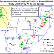
Groundwater Study Area, Wells and Springs, Apalachicola-Chattahoochee-Flint River Basin
Groundwater Study Area, Wells and Springs, Apalachicola-Chattahoochee-Flint River Basin
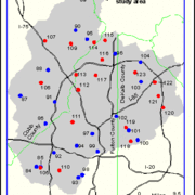
Groundwater Land Use Sites Map, Apalachicola-Chattahoochee-Flint River Basin
Groundwater Land Use Sites Map, Apalachicola-Chattahoochee-Flint River Basin
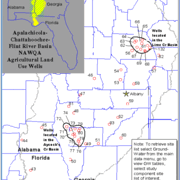
Groundwater Agricultural Land Use Wells, Apalachicola-Chattahoochee-Flint River Basin
Groundwater Agricultural Land Use Wells, Apalachicola-Chattahoochee-Flint River Basin
Special Studies, Reservoir Core Sites, ACF River Basin
Special Studies, Synoptic Atlanta Metro Sites, ACF River Basin
Special Studies, Synoptic Columbus Sites, ACF River Basin
Special Studies, Synoptic Peachtree Creek, Atlanta Sites, ACF River Basin
Special Studies, Synoptic Poultry Sites, ACF River Basin
Special Studies, Synoptic Sope Creek Sites, ACF River Basin
Special Studies, Synoptic Flint River Flood Sites, ACF River Basin
Basin Description Maps
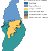
Major Land Resources Map of Apalachicola-Chattahoochee-Flint River Basin
Major Land Resources Map of Apalachicola-Chattahoochee-Flint River Basin
Generalized Outcrop Areas of Apalachicola-Chattahoochee-Flint River Basin
Generalized Outcrop Areas of Apalachicola-Chattahoochee-Flint River Basin
Physiographic Provinces of the Apalachicola-Chattahoochee-Flint River Basin
Physiographic Provinces of the Apalachicola-Chattahoochee-Flint River Basin
Location of Study Area, Apalachicola-Chattahoochee-Flint River Basin
Location of Study Area, Apalachicola-Chattahoochee-Flint River Basin
Land Use Map, Apalachicola-Chattahoochee-Flint River Basin
Land Use Map, Apalachicola-Chattahoochee-Flint River Basin
Journal Articles:
- Callender, E., and Rice, K.C., 2000, The urban environmental gradient: Anthropogenic influences on the spatial and temporal distributions of lead and zinc in sediments: Environmental Science and Technology, v. #34, n. #2, p. #232-238.
- Callender, E., and Van Metre, P.C., 1997, Reservoir sediment cores show U.S. lead declines: Environmental Science and Technology, v. #31, n. #9, p, #424A-428A.
- Couch, C.A., 1997, Fish dynamics in urban streams near Atlanta, Georgia: Watershed Protection Techniques, v. #2, no. 4, p. #511-514.
- Michener, W.K., Blood, E.R., Brim Box, J., Couch, C.A., Golladay, S.W., Hippe, D.J., Mitchell, R.J., and Palik, B.J., 1998, Tropical storm flooding of a coastal plain landscape: extensive floodplains ameliorated potential advers effects on water quality, fishes, and molluskan communities: BioScience v. 48, no. 9, p. 696-705.
- Paul, M.J., Meyer, J.L., and Couch, C.A., 2006, Leaf breakdown in streams differing in catchment land use: Freshwater Biology, v. 51, p. 1684-1695.
- Van Metre, P.C., Callender, E., and Fuller, C.C., 1997, Historical trends in organochlorine compounds in river basins identified using sediment cores from reservoirs: Environmental Science and Technology, v.31, n.8, p. 2339-2344.
Conference Proceedings:
- Baer, K.B., 1995, Impact of stormwater management on aquatic ecosystem integrity: The Sope Creek Case Study: in Hatcher, K.J., (ed.), Proceedings of the 1995 Georgia Water Resources Conference, Athens, Ga., Institute of Ecology, The University of Georgia, p. 269-273.
- Black, D.D., Hughes, W.B., and Gregory, M.B., 2003, Water-quality and ecological assessment of Rottenwood and Sope Creeks, Marietta, Georgia, 2002: in Hatcher, K.J., (ed.), Proceedings of the 2003 Georgia Water Resources Conference, Athens, Ga., Institute of Ecology, The University of Georgia, 4 p.
- Buell, G.R., 1997, National Water Quality Assessment Program: Transport of trace elements and semi-volatile organic compounds in fluvial sediments of the lower Flint River (Georgia) and Apalachicola River (Georgia, Florida, Alabama) basins during Tropical Storm Alberto, July 1994: in Hatcher, K.J., (ed.), Proceedings of the 1997 Georgia Water Resources Conference, Athens, Ga., Institute of Ecology, The University of Georgia, p. 53-61.
- Buell, G.R.and Couch, C.A., 1995, National Water Quality Assessment Program: Environmental distribution of organochlorine compounds in the Apalachicola-Chattahoochee-Flint River Basin, in Hatcher, K. J., (ed.), Proceedings of the 1995 Georgia Water Resources Conference, Athens, Ga., Institute of Ecology, The University of Georgia, p. 45-53.
- Calhoun, D.L., Frick, E.A., and Buell, G.R., 2003, Effects of urban development on nutrient loads and streamflow, upper Chattahoochee River Basin, Georgia, 1976-2001: in Hatcher, K.J., (ed.), Proceedings of the 2003 Georgia Water Resources Conference, Athens, Ga., Institute of Ecology, The University of Georgia, 5 p.
- Couch, C.A., 1993, National Water-Quality Assessment Program: Environmental Setting of the Apalachicoa-Cahttahoochee-Flint River Basin: in Hatcher, K.J., (ed.), Proceedings of the 1993 Georgia Water Resources Conference, Athens. Ga., Institute of Ecology, The University of Georgia, p. 30-32.
- Couch, C. A., 1994, Stream macroinvertebrate communities in watersheds with different land use characteristics in the Apalachicola-Chattahoochee-Flint Basin, [abs.], in Sorenson, Stephen K., ed., 1994, Proceedings abstracts American Water Resources Association's symposium on the National Water-Quality Assessment Program--November 7-9, 1994, Chicago, Illinois: U.S. Geological Survey Open-File Report 94-397, p. 18.
- Couch, C. A., 1997, National Water Quality Assessment Program: Environmental distribution of mercury related to land use and physicochemical setting in watersheds of the Apalachicola-Chattahoochee-Flint River basin: in Hatcher, K.J., (ed.), Proceedings of the 1997 Georgia Water Resources Conference: Athens, Ga., Institute of Ecology, The University of Georgia, p. 45-52.
- Couch, C. A. and Tate, C. M., 1995, Comparison of landscape influences on biological communities in western and eastern watersheds of the U.S. examples from the National Water-Quality Assessment (NAWQA) Program, [abs.]: Bulletin of the North American Benthological Society, Spring 1995, Keystone Resort, Colorado, p. 89.
- DeVivo, J.C., 1995, Impact of introduced red shiners Cyprinella lutrenis on stream fishes near Atlanta, Georgia: in Hatcher, K.J., (ed.), Proceedings of the 1995 Georgia Water Resources Conference, Athens, Ga., Institute of Ecology, The University of Georgia, p. 95-98.
- DeVivo, J.C., Couch, C.A., and Freeman, B.J., 1997, Use of preliminary index of biotic integrity in urban streams around Atlanta, Georgia: in Hatcher, K.J. (ed.), Proceedings of the 1997 Georgia Water Resources Conference: Athens, Ga., Institute of Ecology, The University of Georgia, p. 119-122.
- DeVivo, J.C., Frick, E.A., Hippe, D.J., and Buell, G.R.,1995, Effect of resticted phosphate detergent use and mandated upgrades at two wastewater-treatment facilities on water quality, metropolitan Atlanta, Georgia, 1988-93, in Hatcher, K.J., (ed.), Proceedings of the 1995 Georgia Water Resources Conference, Athens, Ga., Institute of Ecology, The University of Georgia, p. 54-56.
- Frick, E.A., 1997, National Water Quality Assessment Program: Surface-water and shallow ground-water quality in the vicinity of Metropolitan Atlanta, Upper Chattahoochee River Basin, Georgia, 1992-95: in Hatcher, K.J., (ed.), Proceedings of the 1997 Georgia Water Resources Conference: Athens, Ga., Institute of Ecology, The University of Georgia, p. 114-118.
- Frick, E.A., and Buell, G.R., 1999, Relation of land use to nutrient and suspended-sediment concentrations, loads, and yields in the upper Chattahoochee River basin, Georgia, 1993-98 (PDF): in Hatcher, K.J., (ed.), Proceedings of the 1999 Georgia Water Resources Conference, Athens, Ga., Institute of Ecology, The University of Georgia, p. 170-179.
- Frick, E.A. and Crandall, C.A., 1995, National Water Quality Assessment Program: Water quality in surficial aquifers in two agricultural areas in Georgia, Alabama, and Florida, in Hatcher, K.J., (ed.), Proceedings of the 1995 Georgia Water Resources Conference, Athens, Ga., Institute of Ecology, The University of Georgia, p. 42-45.
- Frick, E.A., Stell, S.M., Buell, G.R., 1993, Natonial Water-Quality Assessment Program: A Preliminary evaluation of 1990 nutrient loads for the Apalachicola-Chattahoochee-Flint River Basin: in Hatcher, K.J., (ed.), Proceedings of the 1993 Georgia Water Resources Conference, Athens, Ga., Institute of Ecology, The University of Georgia, p. 36-40.
- Garrett, J.W., Perlman, H.A., Scholz, J.D., 1997, National Water Quality Assessment Program: World wide web access to U.S. Geological Survey publications and data: Apalachicola-Chattahoochee-Flint River basin, Georgia, Alabama, and Florida, 1992-95: in Hatcher, K.J., (ed.), Proceedings of the 1997 Georgia Water Resources Conference: Athens, Ga., Institute of Ecology, The University of Georgia, p. 62-62.
- Gregory, M.B., and Bryant, W.L., 2003, Effects of urbanization on stream ecosystems in the Piedmont Ecoregion of Georgia and Albama - A study design (PDF): in Hatcher, K.J., (ed.), Proceedings of the 2003 Georgia Water Resources Conference, Athens, Ga., Institute of Ecology, The University of Georgia, 5 p.
- Hippe, D.J., 1997, National Water Quality Assessment Program: Pesticide occurrence in the Upper Floridan aquifer in the Dougherty Plain and Marianna Lowlands districts, Southwest Georgia and adjacent areas of Alabama and Florida: in Hatcher, K.J., (ed.), Proceedings of the 1997 Georgia Water Resources Conference: Athens, Ga., Institute of Ecology, The University of Georgia, p. 65-67.
- Hippe, D.J. and Garrett, J.W., 1995, National Water Quality Assessment Program: Water-quality conditions and mass transport in the Flint River related to the flood of July 1994, caused by tropical storm Alberto, in Hatcher, K.J., (ed.), Proceedings of the 1995 Georgia Water Resources Conference, Athens, Ga., Institute of Ecology, The University of Georgia, p. 323-328.
- Hippe, D.J., and Garrett, J.W., 1997, National Water Quality Assessment Program: Spatial distribution of dissolved pesticides in surface water of the Apalachicola-Chattahoochee-Flint River Basin: in Hatcher, K.J., (ed.), Proceedings of the 1997 Georgia Water Resources Conference: Athens, Ga., Institute of Ecology, The University of Georgia, p. 410-419.
- Hippe, D.J., Hatzell, H.H., Ham, L.K., and Hardy, P.S., 1995, National Water Quality Assessment Program, Pesticide occurrence and temporal distribution in streams draining urban and agricultural basins in Georgia and Florida, 1993-94, in Hatcher, K.J., (ed.), Proceedings of the 1995 Georgia Water Resources Conference, Athens, Ga., Institute of Ecology, The University of Georgia, p. 34-41.
- Hopkins, E.H., 2003, Using a geographic information system to rank urban intensity of small watersheds for the Chattahoochee, Flint, Ocmulgee, and Oconee River Basins in the Piedmont Ecoregion of Georgia and Alabama: in Hatcher, K.J., (ed.), Proceedings of the 2003 Georgia Water Resources Conference, Athens, Ga., Institute of Ecology, The University of Georgia, 3 p.
- Hopkins, E.H., and Hippe, D.J., 1999, Can land-use patterns serve as a predictor of pesticide occurrence within an urban landscape?: in Hatcher, K.J., (ed.), Proceedings of the 1999 Georgia Water Resources Conference, Athens, Ga., Institute of Ecology, The University of Georgia, p. 180-186.
- Hughes, W.B., and Berndt, M.P., 2003, National Water-Quality Assessment in Georgia, 2001-2011 (PDF): in Hatcher, K.J., (ed.), Proceedings of the 2003 Georgia Water Resources Conference, Athens, Ga., Institute of Ecology, The University of Georgia, 5 p.
- Peters, N.E., Buell, G.R., and Frick, E.A., 1997, National Water Quality Assessment Program: Spatial and temporal variability in nutrient concentrations in surface waters of the Chattahoochee River basin near Atlanta, Georgia: in Hatcher, K.J., (ed.), Proceedings of the 1997 Georgia Water Resources Conference: Athens, Ga., Institute of Ecology, The University of Georgia, p. 104-113.
- Peters, N.E., Buell, G.R., and Frick, E.A., 1997, Spatial and temporal variability in nutrient concentrations in surface waters of the Chattahoochee River basin near Atlanta, Georgia: in B. Webb (ed.), Freshwater Contamination, International Association of Hydrological Sciences Publication 243, IAHS Press, Wallingford, Oxfordshire, UK, p. 153-165.
- Peters, N.E. and Kandell, S.J., 1997, Evaluation of streamwater quality in the Atlanta region: in Hatcher, K.J., (ed.), Proceedings of the 1997 Georgia Water Resources Conference: Athens, Ga., Institute of Ecology, The University of Georgia, p. 95-99.
- Stell, Susan M., 1993, National Water Quality Assessment Program: analysis of available information on pesticides for the Appalachicola-Chattahoochee-Flint River Basin: in Hatcher, K.J., (ed.), Proceedings of the 1993 Georgia Water Resources Conference, Athens, Ga., Institute of Ecology, The University of Georgia, p. 33-35.
- Wangsness, D.J., 1992, Surface- and ground-water quality studies in the area of Lake Sidney Lanier, Georgia, in proceedings of the Workshop on Lake Lanier's Water Quality, Gainesville, Georgia, July 15, 1992: Athens, Ga., The University of Georgia, Institute of Natural Resources, v. ?, p. ??.
- Wangsness, D.J., 1993, National Water-Quality Assessment Program: overview of the Apalachicola-Chattahoochee-Flint River Basin: in Hatcher, K.J., (ed.), Proceedings of the 1993 Georgia Water Resources Conference, Athens, Ga., Institute of Ecology, The University of Georgia, p. 29.
- Wangsness, D.J., 1997, Design and implementation of the National Water-Quailty Assessment Program--a United States example--Understanding the limitations of using compliance-monitoring data to assess the water quality of a large river basin, in Murphy, I.L., (ed.), Protecting Danube River Basin Resources, NATO International Exchange Programme Proceedings, Budapest, Hungary, May 27-30, 1996: The Netherlands, Kluwar Academic Publishers, p. 89-103.
Master Theses:
- Baer, K.B., 1995, When it rains it drains--Stormwater management in Metropolitan Atlanta: M.S. Thesis, The University of Georgia, Athens, Georgia, 126 p.
- DeVivo, J.C., 1995, Fish assemblages as indicators of water quality within the Apalachicola-Chattahoochee-Flint (ACF) River basin: M.S. Thesis, The University of Georgia, Athens, Georgia, 196 p.
Related Studies:
- Frick, E.A., Henderson, A.K., Moll, D.M., Furlong, E.T., and Meyer, M.T., 2001, Presence of pharmaceuticals in wastewater effluent and drinking water, Metropolitan Atlanta, Georgia, July-September 1999: in Hatcher, K.J., (ed.), Proceedings of the 2001 Georgia Water Resources Conference, Athens, Ga., Institute of Ecology, The University of Georgia, p. 282.
- Frick, E.A., and Zaugg, S.D., 2003, Organic wastewater contaminants in the Upper Chattahoochee River basin, 1999-2002 (PDF): in Proceedings of the 2003 Georgia Water Resources Conference, Athens, Ga., Institute of Ecology, The University of Georgia, 7 p.
- Henderson, A.K., Moll, D.M., Frick, E.A., Zaugg, S.D., 2001, Presence of wastewater tracers and endocrine disrupting chemicals in treated wastewater effluent and in municipal drinking water, Metropolitan Atlanta, 1999: in Proceedings of the 2nd International conference on pharmaceuticals and endocrine disrupting chemicals in water, Minneapolis, Minn., National Ground Water Association, CD-ROM, p. 110.
- Moll, D.M., Frick, E.A., Henderson, A.K., Furlong, E.T., Meyer,. M.T., 2001, Presence of pharmaceuticals in treated wastewater effluent and surface water supply systems, Metropolitan Atlanta, Georgia, July-September 1999: in Proceedings of the 2nd International conference on pharmaceuticals and endocrine disrupting chemicals in water, Minneapolis, Minn., National Ground Water Association, CD-ROM, p. 82-83.
In 1991, the Apalachicola-Chattahoochee-Flint (ACF) River basin was selected for investigation in the NAWQA Program. The watershed boundary of the ACF River basin defines an ecosystem in which the quality of the water is a result of the complex interaction of natural and human influences on land and water resources.
Home
The Apalachicola-Chattahoochee-Flint (ACF) River basin, located in the southeastern United States (fig. 1), was among the first 20 NAWQA study units selected for study in 1991 (Wangsness and Frick, 1991). The ACF River basin drains about 19,800 mi2 in western Georgia, eastern Alabama, and the Florida panhandle, and is comprised of the Chattahoochee and Flint Rivers that converge at Lake Seminole to form the Apalachicola River. The Apalachicola River flows south through the Florida panhandle into Apalachicola Bay, which discharges into the Gulf of Mexico. Basin hydrology is influenced by 16 reservoirs that cause about 50 percent of the mainstem river miles to be in backwater, and play a major role in controlling flow and influencing the quality of water in the basin. The basin is underlain by five major aquifer systems; crystalline rock aquifers in the Blue Ridge and Piedmont physiographic provinces in the northern part of the basin, and four aquifers in the Coastal Plain physiographic province in the southern part of the basin. For more detailed information on the environmental setting of the ACF River basin, see Couch and others (1996).
The goal of the ACF River basin study design is to compare and contrast the effects of predominant land uses on surface- and ground-water quality. Forest and agriculture are dominant land uses and land covers within the ACF River basin, accounting for 59 and 29 percent of the study area, respectively. Most agricultural land in the upper and middle Chattahoochee and upper Flint River subbasins is used for livestock grazing and poultry production, while most agricultural land in the southern ACF River basin is used for row crops and vegetables; and to a lesser extent, orchards. Urban land use accounts for 5.3 percent of the study area. In 1990, the population of the ACF River basin was about 2.64 million people, 60 percent of which lived in the Metropolitan Atlanta area. Wetland areas account for about 5.4 percent of the entire basin. Agricultural and urban land uses are of particular interest within the ACF River basin, because they have the greatest potential impact on the physical, chemical, and biological quality of the surface- and ground-water resources.
The National Water Quality Assessment Program
The National Water-Quality Assessment Program (NAWQA) provides an understanding of water-quality conditions; whether conditions are getting better or worse over time; and how natural features and human activities affect those conditions. Regional and national assessments are possible because of a consistent study design and uniform methods of data collection and analysis. Monitoring data are integrated with geographic information on hydrological characteristics, land use, and other landscape features in models to extend water-quality understanding to unmonitored areas. Local, State, Tribal, and national stakeholders use NAWQA information to design and implement strategies for managing, protecting, and monitoring water resources in many different hydrologic and land-use settings across the Nation.
The USGS implemented the National Water-Quality Assessment (NAWQA) Program in 1991 to develop long-term consistent and comparable information on streams, rivers, ground water, and aquatic systems in support of national, regional, State, and local information needs and decisions related to water-quality management and policy. The NAWQA program is designed to address the following objectives and answer these questions:
- What is the condition of our Nation's streams, rivers, and ground water?
- How are these conditions changing over time?
- How do natural features and human activities affect these conditions, and where are those effects most pronounced?
USGS scientists collect and interpret data about surface- and ground-water chemistry, hydrology, land use, stream habitat, and aquatic life in parts or all of nearly all 50 States using a nationally consistent study design and uniform methods of sampling analysis (access NAWQA protocols).
From 1991-2001, the NAWQA Program conducted interdisciplinary assessments and established a baseline understanding of water-quality conditions in 51 of the Nation's river basins and aquifers, referred to as Study Units. Descriptions of water-quality conditions in streams and ground water were developed in more than a thousand reports (access NAWQA publications). Non-technical Summary Reports, written primarily for those interested or involved in resource management, conservation, regulation, and policymaking, were completed for each of the 51 Study Units. Non-technical national summary reports on pesticides, nutrients, and volatile organic compounds (VOCs) also were completed, in which water-quality conditions were compared to national standards and guidelines related to drinking water, protection of aquatic life, and nutrient enrichment.
NAWQA activities during the second decade (2001-2012) focus in large part on national and regional assessments, all of which build on continued monitoring and assessments in 42 of the 51 Study Units completed in the first cycle (USGS Fact Sheet 071-01).
Selected major activities during the second decade include:
- Studies on five national priority topics including on the fate of agricultural chemicals, effects of urbanization on stream ecosystems, bioaccumulation of mercury in stream ecosystems, effects of nutrient enrichment on aquatic ecosystems, and transport of contaminants to public-supply wells.
- Regional assessments of water-quality and trends in surface water and principal aquifers, which encompass larger regions of the country than the Study Units.
- National assessments of source water and drinking water associated with domestic wells, and with drinking-water supply wells, stream intakes, and finished water associated with community water systems across the Nation.
NAWQA is planning activities for its third decade (2013-2023) (access a summary of the Program's progress through 2008 and setting the stage for the future).
Basin Description:
Description of the Apalachicola-Chattahoochee-Flint River Basin Study Area
The purposes of this report are to describe the environmental setting and the influence of this setting on aquatic ecosystems of the ACF River basin. The environmental setting includes physical, biological, and cultural characteristics of the ACF River basin. The physical setting includes physiographic, soil, climatic, and hydrologic factors. The biological setting summarizes historical and current (1992) information on habitats and aquatic biota within the basin. The cultural setting describes how the human population uses land and water resources within the basin.
Available literature and reports from Federal, State, and local agencies are used to describe the environmental setting of the ACF River basin. Whereas many of these reports deal with topics of limited scope and geographic extent, it is the objective of this report to provide a broad synthesis of topics relevant to understanding determinants of the health of the aquatic ecosystem and water-quality conditions in the ACF River basin.
Although the basinwide scope of NAWQA's ACF River basin study is unprecedented, water-quality assessments of regional scope have been conducted previously in parts of the basin. The USGS conducted two earlier regional water-quality studies, one in the Apalachicola River basin (Elder and others, 1988), and another in the upper Chattahoochee River basin (Cherry and others, 1980).
In 1971, the Georgia Water Quality Control Board (predecessor to the Georgia Department of Natural Resources, Environmental Protection Division) published a water-quality assessment of the Chattahoochee River from its headwaters to Lake Seminole, and an assessment of the Flint River from Fulton County to near Griffin, Ga., (Georgia Water Quality Control Board, 1971a,b). Another water-quality study of regional scope was conducted on West Point Lake by the USGS for the U.S. Army Corps of Engineers (USACOE) (Radtke and others, 1984).
Text extracted from Couch and others 1995.
Location
The ACF River basin NAWQA study area is about 20,400 sq mi This number includes the drainage area at the mouth of the Apalachicola River (19,600 sq mi) (U.S. Army Corps of Engineers, 1985); the New River watershed (about 510 sq. mi.) (U.S. Geological Survey digital files); and the Apalachicola Bay and surrounding coastal areas and barrier islands (about 270 sq. mi.) (U.S. Geological Survey digital files). The Chattahoochee and Flint Rivers merge in Lake Seminole to form the Apalachicola River, which flows through the panhandle of Florida into the Apalachicola Bay, and discharges into the Gulf of Mexico.
Near West Point Lake, the Chattahoochee River defines the state boundaries between Alabama and Georgia. The Flint River basin is contained entirely within Georgia. Except for the upper reaches of the Chipola River in Alabama, the Apalachicola River basin is contained within the panhandle of Florida.
Text extracted from Couch and others 1995.
Physiography
The ACF River basin contains parts of the Physiographic Provinces of the Apalachicola-Chattahoochee-Flint River Basin that extend throughout the southeastern United States. Similar to much of the Southeast, the basin's physiography reflects a geologic history of mountain building in the Appalachian Mountains, and long periods of repeated land submergence in the Coastal Plain Province. Glaciers, which influenced the physiography of much of North America, never extended to the southeastern United States. Physiography within the major provinces is not homogeneous and has been subdivided by the States of Alabama, Florida, and Georgia into the districts shown on the Physiographic Province Map. Although similar physiography may extend across state boundaries, districts may be assigned different names by state geologists in each state.
The northernmost part of the ACF River basin is within the Blue Ridge Province where headwaters of the Chattahoochee River arise. Less than one percent of the basin lies within the Blue Ridge Province. The Blue Ridge Province is dominated by rugged mountains and ridges that range in altitude from 3,000 to 3,500 feet (ft). The boundary between the Blue Ridge and the Piedmont is defined by a sharp change in slope at an altitude of approximately 1,700 ft. The Blue Ridge and Piedmont Provinces are underlain by mostly Precambrian and older Paleozoic crystalline rocks that include mica schist, felsic gneiss and schist, and granite and granite gneiss. Less extensive outcrops of quartzites are also present.
The part of the ACF River basin within the Piedmont Province in Georgia contains parts of seven physiographic districts-the Dahlonega Upland, the Hightower-Jasper Ridges, the Central Uplands, the Gainesville Ridges, Winder Slope, the Greenville Slope, and the Pine Mountain Districts (Clark and Zisa, 1976). In the Piedmont Province within Alabama, the ACF River basin lies in the Piedmont Upland District (Copeland, 1968).
The northeast trending linear-ridge structure of the Hightower-Jasper Ridges, the Central Uplands and Gainesville Ridges Districts strongly control the course of the upper Chattahoochee River and its tributaries. In particular, highly fractured faults in the Gainesville Ridges District forces the Chattahoochee River and its tributaries into a rectangular drainage pattern. Within these three ridge districts, altitudes range from about 1,500 ft in the northeast and to about 1,000 ft in the southwest. Relief, the distance between minimum and maximum altitudes, varies from approximately 500 ft in the northeast to 100-200 ft in the southwest (Clark and Zisa, 1976).
The Greenville Slope District in Georgia and the Piedmont Upland District in Alabama are both characterized by rolling topography with altitudes ranging from 1,000 ft in the Greenville Slope to 500-800 ft in the Piedmont Upland (Clark and Zisa, 1976; Copeland, 1968). Streams occupy broad, shallow valleys separated by broad, rounded divides and have dendritic drainage patterns.
The Pine Mountain District in Georgia rises abruptly from the Greenville Slope District to altitudes of 1,200-1,300 feet. The Pine Mountain District is dominated by Pine Oak Mountain, which is capped by quartzite. This district is notable for the presence of natural, warm-water springs flowing from fractured quartzite. Watersheds on the southern face of this west-to-east trending mountain ridge have rectangular drainage patterns (Clark and Zisa, 1976).
The Fall Line is the boundary between the Piedmont and Coastal Plain Provinces. This boundary approximately follows the contact between crystalline rocks of the Piedmont Province and the unconsolidated Cretaceous and Tertiary sediments of the Coastal Plain Province. As implied by the name, streams flowing across the Fall Line can undergo abrupt changes in gradient which are marked by the presence of rapids and shoals. Geomorphic characteristics of streams differ between the Piedmont and Coastal Plain Provinces. In the Coastal Plain, streams typically lack the riffles and shoals common to streams in the Piedmont, and exhibit greater floodplain development and increased sinuosity (Wharton, 1978).
The Coastal Plain Province contains three distinct regions-a hilly region immediately below the Fall Line; a region of karst topography; and a low-lying coastal region. The Fall Line Hills District in Georgia and Alabama, and the Chunnennuggee and Southern Red Hills Districts in Alabama are highly dissected with relief ranging 50-250 ft. Cretaceous sediments lie in a band immediately below the Fall Line and crop out into younger Eocene-Paleocene sediments of the low-lying Dougherty Plain District.
The Dougherty Plain and the Mariana Lowlands Districts are characterized by outcrops of the Ocala and Suwannee Limestones that result in a karst topography. The Dougherty Plain slopes southwestward with altitudes of 300 ft in the northeast to less than 100 ft near Lake Seminole. The flat to very gently rolling topography contains numerous sinkholes and associated marshes and ponds. Small streams in the Dougherty Plain District are frequently intermittent during the summer. The eastern boundary of the ACF River basin includes a small portion of the Tifton Upland District where the boundary with the Dougherty Plain is defined by the steeply sloping Pelham Escarpment. This solution escarpment continues to the northeast, forming the surface-water divide between the Flint River basin and the Ochlockonee River basin to the east.
A detailed description of physiography in the Apalachicola River basin is contained in Leitman and others (1983). The upper part of the basin lies within the Tallahassee Hills, Grand Ridge, New Hope Ridge, and Marianna Lowlands Districts. As it flows through the Tallahassee Hills District, the Apalachicola River is bordered on the east side by steep bluffs. The Tallahassee Hills District has altitudes as high as 325 ft, and is bounded on the south by the Cody Scarp, where elevations drop 15 to 20 ft to the Gulf Coast Lowlands. The Marianna Lowlands is a karst plain drained by the Chipola River, the largest tributary within the Apalachicola River basin.
The Gulf Coast Lowlands lie south of the Tallahassee Hills, Grand Ridge and New Hope Ridge Districts and extend to the Gulf of Mexico. This flat, sandy lowland was shaped by waves and currents during inundation by Pleistocene seas. This district is less than 100 ft in elevation. As the Apalachicola River flows southward through the Gulf Coast Lowlands, its floodplain broadens in width from 3 to 5 miles (mi).
Text extracted from Couch and others 1995.
Soils
Three major soil orders-ultisols, entisols, and spodosols, and more than 50 soil series-are present in the ACF River basin (Hajek and others, 1975; Perkins and Shaffer, 1977; Caldwell and Johnson, 1982). Ultisols are characterized by sandy or loamy surface horizons and loamy or clayey subsurface horizons. These deeply weathered soils are derived from underlying acid crystalline and metamorphic rock. Entisols are young soils with little or no change from parent material and with poorly developed subhorizons. These soils are frequently infertile and droughty because they are deep, sandy, well-drained, and subject to active erosion. Spodosols are characterized by a thin sandy subhorizon underlaying the A horizon. This sandy subhorizon is cemented by organic matter and aluminum. The ACF River basin is similar to much of the southeastern coastal plain in the dominance of ultisols. Entisols are found at and below the Fall Line and in the Dougherty Plain; and spodosols are found in the Gulf Coast Lowlands.
Soils of the ACF River basin are divided into six major land-resource areas (10K) (formerly called soil provinces). The Southern Piedmont, Georgia Sand Hills, Southern Coastal Plain, and Eastern Gulf Coast Flatwoods land-resource areas cover 97 percent of the ACF River basin. The Southern Piedmont land-resource area is dominated by ultisols. Piedmont ultisol soils are acid, low in nitrogen and phosphorus, and generally lack the original topsoil. Topsoil erosion began with intensive cultivation of cotton in the 1800's (Wharton, 1978).
Soils in the Southern Coastal Plain and the Georgia Sand Hills land-resource areas are derived from marine and fluvial sediments eroded from the Appalachian and Piedmont Plateaus. Ultisols are found throughout the Southern Coastal Plain, with the exception of some areas in the Georgia Sand Hills and Dougherty Plain where entisols locally are present.
The Eastern Gulf Coast Flatwoods land-resource area, which composes much of the Apalachicola River basin, is dominated by spodosols. Spodosols of the low-lying Eastern Gulf Coast Flatwoods are poorly-to-very poorly drained.
Basinwide patterns in soil leaching and runoff potential provide information on areas that may be susceptible to greater contaminant transport through infiltration or runoff. Soils with high leaching rates are concentrated in the sandy Cretaceous sediments below the Fall Line and in the sandy surficial sediments of the East Gulf Coast Flatwoods.
Runoff ratings are based on the inherent capacity of bare soil to permit infiltration, and consider slope, frequency of flooding during the growing season, and permeability (Brown and others, 1991). Soils with high runoff ratings are distributed throughout the basin, but are concentrated in areas having low permeability, steep slopes; or where flooding is frequent or the water table is near the surface, such as in floodplains and other low-lying areas. In the ACF River basin, soils with the highest runoff rate are present on steep slopes in the Blue Ridge, several areas in the Piedmont Province, the Fall Line Hills District, and in the lower Apalachicola River basin where soils commonly remain saturated.
Text extracted from Couch and others 1995.
Climate
The ACF River basin is characterized by a warm and humid, temperate climate. Major factors influencing climate variability in the basin are latitude, altitude, and proximity to the Gulf of Mexico.
Because the ACF River basin spans about 5 degrees of latitude, it has a sharp gradient in growing seasons. Average annual temperature ranges from about 60 °F in the north to 70 °F in the south. Average daily temperatures in the basin for January range from about 40 °F to 55 °F, and for July from 75 °F to 80°F. In the winter, cold winds from the northwest cause the minimum temperature to dip below freezing for only short periods. Summer temperatures commonly range from the 70's to the 90's.
Precipitation is greatest either in the mountains as a result of their orographic effect or near the Gulf of Mexico as a result of the availability of moist air. Average annual precipitation in the basin, primarily as rainfall, is about 55 inches (in.), but ranges from a low of 45 in. in the east-central part of the basin to a high of 60 in. in the Florida panhandle (U.S. Geological Survey, 1986).
Evapotranspiration generally increases from north to south and ranges from about 32 to 42 in. per year. In the east-central part of the basin, precipitation and evapotranspiration are about equal. Average annual runoff ranges from 15 to 40 in. Runoff is greatest in the Blue Ridge Mountains and near the Gulf coast (Gebert and others, 1987).
Text extracted from Couch and others 1995.
Surface-Water Hydrology
The Chattahoochee and Flint River basins in Georgia contain most of the headwater watersheds for surface waters that flow into or are used by the Florida and Alabama parts of the basin. This section describes the hydrology of the Chattahoochee, Flint, and Apalachicola River basins. Throughout the ACF River basin, low flows usually occur from September to November and peak flows usually occur from January to April when rainfall is high and evapotranspiration is low.
Chattahoochee River Basin
The Chattahoochee River-whose name is derived from Creek Indian words meaning painted rock-drains an area of 8,770 sq mi and is the most heavily used water resource in Georgia. The Chattahoochee River arises as a cold-water mountain stream in the Blue Ridge Province at altitudes above 3,000 ft and flows 430 mi to its confluence with the Flint River. The discharge of the Chattahoochee River based on median daily flows near Columbia, Ala., during water years 1977-92 was 8,250 cubic feet per second (cfs). Median daily discharge ranged from a low of 498 cfs in 1989 to a high of 191,000 cfs in 1990.
Thirteen of 16 dams on mainstem locations in the ACF River basin are on the Chattahoochee River. Dam construction in the basin began in the early 1800's on the Chattahoochee River above the Fall Line at Columbus, Ga., to take advantage of natural gradients for power production. Annual flow has not been appreciably altered by the system of dams, although storage is used to augment flows during periods of low flow; and daily fluctuations below some reservoirs can be dramatic. Pronounced decreases in the frequency of high and low flows have occurred since the start of operation of Buford Dam that forms Lake Sidney Lanier. Lake Sidney Lanier, West Point Lake, and Lake Walter F. George provide most water storage available to regulate flows in the basin. Lake Sidney Lanier alone provides 65 percent of conservation storage, although it drains only 5 percent of the ACF River basin. In addition, West Point Lake and Lake Walter F. George provide 18 and 14 percent, respectively, of the basin's conservation storage (Leitman and others, 1991).
Over most of its length, the flow of the Chattahoochee River is controlled by hydroelectric plants releasing water for production of hydropower. These hydroelectric plants use hydropeaking operations to augment power supply during peak periods of electric demand. At Cornelia, Ga., the Chattahoochee River is free flowing; however, throughout the remainder of its length, the river's hydrograph shows the influence of hydropeaking operation. Hydropeaking operations can result in daily stage fluctuations of 4 ft or more.
In contrast to the mainstem Chattahoochee River, many tributaries remain free flowing. Flows of tributaries in forested basins are represented by Snake Creek that drains 35.5 sq mi above streamflow-gaging station 02337500. Flows typical of urban basins are represented by Peachtree Creek. Above streamflow-gaging station 02336300, Peachtree Creek drains a 86.8 sq mi urban basin in Metropolitan Atlanta. Similar to most Piedmont streams, both streams have higher sustained flows during winter months, and show responses to storm events throughout the year. However, sharper peaks in the hydrograph of Peachtree Creek reflect the greater influence of impervious land cover in this urban basin.
Flint River Basin
The Flint River is about 350 miles long and drains an area of 8,460 sq. mi. Most of the larger tributaries in the ACF River basin are located in the Coastal Plain Province part of the Flint River basin. These tributaries-with their Creek Indian meaning in parentheses-include Ichawaynochaway Creek (buck sleeping place), Chickasawhatchee Creek (council house creek), Kinchafoonee Creek (mortar bone or pounding block creek), and Muckalee Creek (pour-upon-me creek) (Utley and Hemperley, 1975).
Spring Creek, formerly a Flint River tributary that now discharges directly into Lake Seminole, drains 585 sq mi in a region of karst topography. As implied by its name, flow in Spring Creek is dominated by ground-water discharge directly into its limestone bed.
From 1977-92, the discharge of the Flint River based on mean daily flows at Newton, Ga., was 4,030 cfs. Mean daily discharge ranged from 922 cfs in 1991 to 47,000 cfs in 1990. Two hydropower dams located on the Flint River impound run-of-the-river reservoirs and do not appreciably influence the flow of the Flint River. The Flint River has one of only 42 free-flowing river reaches longer than 125 mi remaining in the contiguous 48 states (Benke, 1990).
Higher flows during winter months are evident in the annual hydrographs of the Flint River, Ichawaynochaway Creek, and Spring Creek. During winter months, Coastal Plain streams, such as Ichawaynochaway and Spring Creeks, flow for sustained periods through their floodplains.
Apalachicola River Basin
The Apalachicola River flows unimpeded for 106 mi from Jim Woodruff Lock and Dam to the Gulf of Mexico. The river drains about 2,600 sq mi and its shallow estuary covers about 208 sq mi. Tidal influences do not extend beyond 25 mi upstream from the river's mouth. The Apalachicola River falls 40 ft as it flows through the Gulf Coast Lowlands. The width of the river ranges from several hundred feet when confined to its banks to nearly 4-1/2 mi during high flows. The discharge of the Apalachicola River is 21st in magnitude among the rivers of the conterminous United States, and is the largest in Florida, accounting for 35 percent of freshwater flow on the western coast of Florida (Livingston, 1992). During 1977-92, the discharge of the Apalachicola River based on mean daily discharge at Sumatra, Fla., was 19,602 cfs. Mean daily discharge at Sumatra ranged from 5,800 cfs in 1981 to 178,000 cfs in 1990. Eighty percent of the Apalachicola River flow is contributed by the Chattahoochee and Flint Rivers, 11 percent from the Chipola River, and less than 10 percent from ground water and overland flow (Elder and others, 1988). The Chipola River-Apalachicola River's largest tributary-drains one-half of the Apalachicola River basin. The Chipola River is classified as a spring-fed river with baseflow derived principally from aquifers.
Because of rainfall-distribution patterns, the average annual runoff from the Chattahoochee River exceeds that of the Flint River. The Chattahoochee River makes a greater contribution to peak flows in the Apalachicola River than the Flint River. However, during extreme dry periods, the greater flow contribution in the Apalachicola River comes from the Flint River, where baseflow is sustained by ground-water discharges (Elder and others, 1988).
Leitman and others (1983) studied stage and discharge records from 1929-79 to determine if significant hydrologic changes occurred in the Apalachicola River as a result of dam-flow regulation. Dams have had little effect on the magnitude of high flows or seasonal distribution of discharge over an annual cycle. Dam regulation did reduce the amount of time that flow was at low extremes. Water stages in the river within the first 30 mi downstream of Jim Woodruff Lock and Dam have lowered due to scouring of the river bottom.
Text extracted from Couch and others 1995.
Groundwater Hydrology
Six major aquifers underlie the ACF River basin. These aquifers, listed in descending order, are the surficial aquifer system, the Floridan aquifer system, the Claiborne aquifer, the Clayton aquifer, the Providence aquifer, and the crystalline rock aquifer. Generalized outcrop areas and stratigraphy of aquifers underlying the Coastal Plain Province generally are separated by confining units.
Aquifers in the Coastal Plain Province consist of alternating units of sand, clay, sandstone, dolomite, and limestone that dip gently and thicken to the southeast. Confining units between these aquifers are mostly silt and clay. From the Fall Line to the Gulf of Mexico, progressively younger sediments crop out and overlie older sediments. The complex interbedded clastic rocks and sediments of Coastal Plain aquifers range in age from Quaternary to Cretaceous. Because of gradational changes in hydrologic properties, aquifer and stratigraphic boundaries are not always coincident.
The surficial aquifer system is a shallow, mostly unconfined water-table aquifer consisting of cross-bedded sand, gravel and clay with undifferentiated alluvium near rivers. Surficial deposits are associated with all outcrop areas shown on the Generalized Outcrop map. However, only in the southern part of the ACF River basin do these deposits contain ground water whose use warrants mapping as a single aquifer (Miller, 1990). Isolated domestic wells withdraw water from the surficial aquifer system.
The Floridan aquifer system, one of the most productive aquifers worldwide, underlies about 100,000 sq mi in Florida, southern Alabama, southern Georgia, and southern South Carolina. The Floridan aquifer system comprises of a thick sequence of carbonate rocks that are of Tertiary age and are hydraulically connected in varying degrees (Miller, 1986). The Ocala Limestone is one of the thickest and most productive formations that crops out in the Dougherty Plain and gives rise to a karst topography riddled with sinkholes. The complex hydrogeology of the Floridan aquifer system is reflected by highly variable transmissivities that range from 2,000 to 1,300,000 feet squared per day (sq ft/d). Range in transmissivities in the Ocala Limestone is caused by the variable, fractured nature, and the dissolution of limestone that creates conduits and solution openings (Miller, 1986).
The Tallahatta Formation of Eocene age is the principal water-bearing formation of the Claiborne aquifer (McFadden and Perriello, 1983). The Clayton Formation of Paleocene age is the water-bearing formation of the Clayton aquifer. Cretaceous units crop out immediately below the Fall Line. The principal water-bearing formation is the Providence Sand of Late Cretaceous age (McFadden and Perriello, 1983). Older Cretaceous strata generally are too deep to be economically developed.
Aquifers in the Piedmont and Blue Ridge Provinces are in crystalline rocks that crop out in the northern part of the basin and extend to the Fall Line. These crystalline rocks have similar hydraulic characteristics and are mapped as one aquifer. The metamorphic and igneous crystalline rocks of the crystalline aquifer are overlain by pockets of regolith (weathered, unconsolidated rock debris) of varying thicknesses. The greatest thicknesses of regolith, as much as about 100 ft, are in draws and valleys. Because the crystalline rocks have few primary pore spaces, ground water is obtained primarily from the regolith and from fractures in the rock. Reported yields of wells completed in these rocks range from zero to 471 gallons per minute (gal/m) but are commonly less than 50 gal/m (Cressler and others, 1983; Chapman and others, 1993).
The regional direction of ground-water flow is from north to south; however, local flow directions vary, especially in the vicinity of streams and areas having large ground-water withdrawals. Rivers and streams in the Coastal Plain Province commonly are deeply incised into underlying aquifers and receive substantial amounts of ground-water discharge. Strata associated with the Floridan aquifer system are exposed along sections of the Apalachicola, Chattahoochee, and Flint Rivers; and Spring Creek (Maslia and Hayes, 1988). As a result of the hydraulic connection between the Floridan aquifer system and the Flint River, ground-water discharge contributes more significantly to baseflow in the Flint River than in the Chattahoochee River. Aquifer discharge to the Chattahoochee River is estimated to be one-fifth of the amount that discharges to the Flint River (Torak and others, 1993).
Text extracted from Couch and others 1995.
Study Design
Goals of Study Design
Much of the historical data and current monitoring programs focus on point-source inputs and their effect on mainstem rivers. Since the effects of nonpoint-source inputs from various land uses is poorly understood, the NAWQA Program has been designed to fill that information gap. Because the ACF River basin is too large to allow for the detailed study of each stream and aquifer, several small watersheds and aquifer systems were selected to represent a predominant land use and/or physiographic area. The term predominant land use is used to describe areas of mixed land uses that are dominated by one land-use type (e.g. 60 percent row-crop agriculture and a mix of other land uses), but are not homogeneous (e.g. 100 percent row-crop agriculture). The ideal study design for comparison of land-use effects on water quality is a system of paired watersheds having different, homogeneous land uses. The goal of NAWQA is to describe water quality in large areas of the country, however, large areas of homogeneous land use generally do not exist in the ACF River basin. Therefore, small watersheds with no point-source inputs and having mixed land use, predominated by the target land use and typical of other small watersheds in the area, were selected for study. These small watersheds, ranging from about 18-105 sq mi in area, represent a medium-sized scale of study that provides the link between small-scale studies (ie. farm-field level studies) and large-scale studies (ie. large tributaries and mainstem rivers draining mixed land uses and physiography, and containing point-source inputs). Because the goal of the study is to document water quality and describe the effects of land uses on water quality in the ACF River basin, it is necessary to study effects of land use at a medium scale, address some specific questions at a smaller scale, but ultimately be able to transfer what was learned at those scales to larger areas of the basin. It is this nested study design that will be described in greater detail in the following sections of this report.
During the development of the study design, the goal was to integrate surface-water, ground-water, and biological components where possible so as to be able to document the current water quality of the study area, to begin to describe the effects of predominant land uses on that water quality, and to lay the foundation for future evaluation of the surface- and ground-water resources as an integrated system. The design primarily focuses on nonpoint-source inputs of nutrients, sediment, and pesticides from agricultural, urban, and forested land uses. The primary agricultural land uses of interest are poultry production in the headwaters of the ACF River basin (Piedmont physiographic province) and production of row crops in the southern half of the basin (Coastal Plain physiographic province). The urban land uses of interest are intensive commercial areas, such as downtown Atlanta, and suburban residential areas, such as those surrounding Atlanta. In some parts of the country forested lands represent large undisturbed areas and are suitable for collection of background information. Forested lands in the ACF River basin generally are being managed silviculturally. But even though the forested lands have been, or are being disturbed, they are the best representation of background water-quality conditions, and their effect on water quality is of value for comparison to other land uses.
Text extracted from Wangsness, 1996
Surface-water Sites
The surface-water system of the ACF River basin was stratified based on physiography and major land uses. Water-quality monitoring locations were then chosen to represent predominant land uses at various scales. The monitoring network reflects the nested study design described earlier, starting with a few fixed monitoring sites (integrator sites and indicator sites, a subset of which were intensive monitoring sites), adding a group of comparison sites, and finally a group of sampling sites on large tributaries and main-stem rivers. Water samples were collected at frequencies varying from hourly to annually, depending on the intended purpose. The different monitoring sites, sample types, and sample frequencies are described in the following sections. Site numbers assigned to each location are provided as a cross-reference to the locator maps.
-Integrator Sites
Because there already was an extensive monitoring network in the basin, supported by State and Federal agencies, the NAWQA study design focused on three integrator sites located on mainstem rivers; two on the Chattahoochee River upstream and downstream of Metropolitan Atlanta, and one on the Apalachicola River near the mouth. The first two sites were selected to provide an estimate of total load of selected constituents in the Chattahoochee River upstream and downstream of a major source of point and nonpoint inputs to the river. Extensive monitoring of many point-source discharges to the river and tributaries provide data to estimate point-source loads of selected constituents and, by difference, estimate nonpoint-source loads from tributaries draining Metropolitan Atlanta. The site near the mouth of the Apalachicola River was selected to provide an estimate of total load of selected constituents entering Apalachicola Bay. These data are valuable for comparing current and historical water-quality conditions, for documenting current water-quality conditions, and for analysis of long-term trends in the future.
-Indicator Sites
Six indicator sites located on small streams having drainage areas ranging from about 18-105 sq mi, represent target land uses and physiography. West Fork Little River, the most upstream basin, represents water quality in an area of intensive poultry production. The primary issue is nutrient input from poultry litter that is spread on pastures surrounding the production areas. Sope Creek and Peachtree Creek are located within Metropolitan Atlanta and represent water quality in intensive urban and suburban watersheds, respectively. Sope Creek receives runoff from residential areas, and from suburban commercial areas and transportation networks that are less dense than areas within the City of Atlanta. Peachtree Creek receives runoff from dense commercial areas and transportation networks associated with the City of Atlanta, and inputs from combined sewer overflows (CSOs). Snake Creek receives runoff from an area that is predominantly forested. Tracts of land within the basin have been harvested for pulp and lumber and, therefore, the basin does not represent an unimpacted control watershed. However, since about sixty percent of the ACF River basin is forested, and under some type of silvicultural management, Snake Creek is typical and representative of forested basins within the study unit. Lime Creek and Aycocks Creek represent water quality in areas of intensive row-crop agriculture. Unlike parts of the United States where large, continuous tracts of land often are farmed to the stream bank, farming in the Coastal Plain of the southeastern United States is generally limited to well-drained uplands. This results in smaller and more discontinuous farm fields that do not extend to the river bank. Instead, streams generally are protected from overland runoff by natural buffers consisting of forested wetlands and floodplains. However, the potential remains high for the movement of farm chemicals to streams because the climate and availability of ground water for irrigation are favorable for multi-cropping practices that can result in the application of nutrients and pesticides to fields throughout much of the year.
-Intensive Sites
Sampling sites on Sope, Lime, and Aycocks Creeks were selected as intensive sites and were sampled frequently during a 1-year period to provide temporal data that defines the seasonal distribution of nutrients, sediment, and pesticides. Samples collected nearly once each week and several times during storm hydrographs, provided valuable information on the occurrence, magnitude, and distribution of constituents in the stream system. This information not only helps to assess the water quality of those representative basins, but also can be used to adjust future monitoring programs by targeting specific constituents and key times for conducting intensive sampling.
-Comparison Sites
For each of the six indicator sites 5-6 comparison sites were chosen. Three sites were chosen for between-basin comparison and 2-3 for within-basin comparison. Those sites chosen for between-basin comparison met the same criteria as sites in the indicator basin. In theory, if data collected at all targeted land-use sites during basin-wide synoptic surveys indicated that all basins had very similar water-quality characteristics, then information gained through intensive monitoring of one could be transferred to the others. Within-basin comparison sites were selected to represent inputs from tributaries or sub-basins upstream of the indicator site to help define within-basin variability.
-Synoptic Sites
Monitoring sites were identified near the mouths of major tributaries, upstream and downstream of major reservoirs, and at additional locations on the main-stem rivers. These sites completed the surface-water monitoring network and assured a more complete spatial coverage than the sampling sites described above could provide alone. Synoptic surveys of the entire monitoring network were conducted three times during the period of study (June 1993, March and May 1994). Surveys were conducted during spring and early summer to coincide with periods of nutrient and pesticide applications to urban and agricultural lands.
-Bed Sediment and Tissue
Two bed sediment and tissue surveys were conducted early in the project to provide information useful to the overall study design. An initial survey of 31 sites consisting of integrator, indicator, selected main-stem river, and reservoir sites was conducted in 1992 to determine occurrence of organic compounds and trace metals in bed sediments and the Asiatic clam Corbicula fluminea. A second survey that included resampling of many of the initial sites and 15 additional sites, primarily in urban and suburban watersheds, was conducted in 1993 to better define the distribution of organic compounds and trace metals throughout the ACF River basin. Additional bed sediment samples were collected at 19 sites in September 1994, following the record flooding caused by Tropical Storm Alberto.
Because of the basin-wide distribution of Corbicula fluminea, it was exclusively analyzed to assess the bioaccumulation of organic compounds and trace metals in tissue, except at three locations in the Apalachicola River floodplain where Gambusia affinis holbrooki (mosquitofish) was used for tissue analysis.
-Biological
Biological samples were collected at least once a year at each of the indicator sites and at their respective comparison sites, and a measure of terrestrial and in-stream habitat made once during the period of study. The most intensive sampling effort was conducted at the six indicator sites. A stream reach 6-10 times as long as the average width that contained replicate examples of the various habitats (i.e. pools, riffles, overhangs, submerged logs) was defined. As cross-sectional areas for sampling were identified, care was taken to minimize disturbance of the cross section. Individual quantitative samples of macroinvertebrates and benthic algae were collected from potentially rich habitats such as cobble and gravel substrates in riffles, and depositional areas such as sand and mud in pools. Qualitative samples were collected from these same habitats and, additionally, from other habitats such as the surfaces of living or dead vegetation, root and leaf mats, and overhanging banks in an attempt to provide data on relative abundance, and to better define a complete species list. Fish were collected using techniques such as electroshocking, seines, dip nets, or combinations of these techniques that provided the most representative sample of the fish community. Measurements of in-stream habitat included stream width, depth, and velocity; size and distribution of substrates; amount and type of submerged and emergent vegetation; and estimates of the percent of pools and riffles. Measurements of terrestrial habitat included bank slope and stability; vegetation type, size, and density; and percent of cover overhanging the stream. A less intensive sampling effort was performed at the comparison sites to conserve funds and human resources. Priority was placed on the collection of a representative sample of the fish community; single, qualitative/semiquantitative samples of macroinvertebrates and benthic algae, and measurements of in-stream habitat.
Groundwater Sites
Because few ground-water data existed within the ACF River basin prior to this study, the groundwater monitoring network was designed primarily to provide information on the occurrence and distribution of a large suite of compounds that can be used to better identify problem areas, and define related questions and issues. Data collected during this first cycle of intensive data collection also will provide a valuable reference for comparison with the data collected during subsequent cycles of intensive data collection.
-Study Unit Survey
The study-unit survey was designed to characterize the quality of shallow ground water within the Upper Floridan Aquifer System and to determine the effects of land use. An area of about 3,900 sq mi in the southern part of the study unit, known locally as the Dougherty Plain and Marianna Lowlands, and underlain by the Floridan aquifer system, was selected for the ground-water study-unit survey. The predominant land use in the Dougherty Plain and Marianna Lowlands is row-crop agriculture and orchards. The source of some public and most domestic water supply is the Floridan aquifer system, a highly productive fractured limestone aquifer having karst features. To establish sampling sites within the Dougherty Plain and Marianna Lowlands, the area was subdivided into 30 polygons of similar size and existing wells or, where present, one or two high-flow springs were chosen for sampling from each polygon. Forty two sites were selected for sampling. Depth to water in the monitoring wells ranged from 10-60 ft below land surface (one well was a flowing well with approximately 3 ft of head). Each site was sampled once in August or September 1995. Samples were analyzed for nutrients, pesticides, volatile organic compounds, trace metals, major ions, organic carbon, stable isotopes, and selected radionuclides. On-site measurements of ground-water levels, flow from springs, and field measurements were made at each site.
-Land Use Studies
The agricultural land-use study was designed to determine the chemical quality of shallow ground water that underlies agricultural areas in a 6,700 sq mi area of the southern part of the ACF River basin. Sites for monitoring the surficial aquifer were located randomly using the computer program developed for the NAWQA program (Scott, 1990) and wells were installed according to NAWQA guidelines (Lapham and others, 1995) adjacent to and downgradient of 37 farm fields. Four reference wells were installed in forested areas to represent background water-quality conditions. The depth to the water table in the surficial aquifer monitoring wells ranged from about 3-67 ft below land surface. Surficial aquifers were selected for sampling rather than deeper aquifer systems because surficial aquifers are the first water-bearing zones to receive recharge from infiltration, and presumably are more susceptible to contamination. Therefore, water-quality conditions in surficial aquifers may serve as an early warning of potential contamination of deeper aquifer systems that are used for drinking-water supply and irrigation. Water samples were collected from all wells during summer 1993 and from most wells during spring 1994. The sample times represented low and high water-table conditions, respectively. The samples were analyzed for nutrients, pesticides, volatile organic compounds, major ions, organic carbon, and selected radionuclides. On-site measurements of water levels and field parameters also were made at each site.
The urban land-use study was designed to determine the chemical quality of shallow ground water that underlies Metropolitan Atlanta within a 350 sq mi area of the surficial drainage to the Chattahoochee River. Sampling sites were established by subdividing the study area into 30 polygons of equal area using the computer program developed for NAWQA (Scott, 1990), and then selecting an existing domestic or observation well, and where present, a spring, from each polygon. Forty locations were selected as sampling sites. Depth to water in the monitoring wells ranged from 2-29 ft below land surface. Each site was sampled once during the period from summer 1994 through spring 1995. Samples were analyzed for nutrients, pesticides, volatile organic compounds, major ions, organic carbon, trace metals, and selected radionuclides. On-site measurements of water levels, flows from springs, and field parameters also were made at each site.
-Flow System Studies
The ground-water flow-system study was designed to track the transport of nutrients and pesticides from a field where they were applied, through the shallow flow system that underlies the field and the adjacent forested floodplain/wetland, to areas of discharge to the surface-water system. During previous studies of a 1,000-acre field, nutrients and pesticides were measured in two shallow ground-water monitoring wells adjacent to and down-gradient from the field. Three generalized flow paths were identified within the study area: 1) shallow ground water collected by a network of tile drains within the field that discharged to ditches; 2) shallow ground water flowing from the farmed upland area and discharging along the toe slope at the edge of the forested flood plain; and 3) shallow ground water flowing from the farmed upland area, through the alluvial sediments within the flood plain, and discharging directly to the stream. Sampling points were located along two transects from edge of field to stream. Shallow monitoring wells were installed at each sample point, including points adjacent to the stream and within the stream bed; lithologic information was recorded; and water samples were collected and analyzed from each well and from the stream. Based on an evaluation of those data, additional sample locations were selected to provide better characterization of the system. These included additional wells installed along the transects between existing locations, nests of wells installed at varying depths at existing locations, springs located along the base of the toe slope that separated the forested upland from the forested flood plain, and three pipes connected to a network of tile drains throughout the field that discharged into two drainage ditches that flowed through the flood plain. The complete network of sample locations included 34 wells, 3 springs, 3 drains, and 2 surface-water sites. The frequency of sample collection and the list of constituents analyzed in water samples varied, but a core of sites were sampled 3 times a year to represent different seasons and flow conditions. Most samples were analyzed for nutrients, pesticides, major ions, and organic carbon. On-site measurements of water levels, flows, and field parameters also were made during each visit.
Special Studies
The study design for the ACF River basin study unit was modified to include four special studies: 1) addition of an intensive network of synoptic sites within the poultry, urban and suburban basins; 2) analysis of sediment cores collected from six of the reservoirs within the study unit; 3) intensive sampling of the Flint River during record flooding; and 4) seasonal sampling of fish to determine community recovery following the record flooding. Each of these activities was pertinent to the assessment of water-quality conditions within the ACF River basin, and also provided information of value to both regional and national synthesis efforts.
A network of surface-water monitoring sites, which included the poultry indicator site, three-between basin comparison sites, and seven additional sites, were sampled during a two-day synoptic survey that represented baseflow conditions in the upper Piedmont region of the ACF River basin. Three surveys were conducted within Sope Creek which included the indicator and within basin comparison sites and an additional twelve sites located within the Sope Creek basin. Two surveys were conducted within the metro Atlanta area. Eleven sites were sampled in May 1995. The second survey, conducted during July 1995, was expanded to include 39 sites within metropolitian Atlanta and Columbus, including integrator, indicator, comparison, large tributaries, two additional mainstem sites, and 19 sites located within the Peachtree Creek basin. The purpose for these surveys was to locate areas of ground-water discharge that would provide the basis for a flow-system study, and to better define water quality in small basins affected by urban and suburban land uses. On-site measurements of flow and field parameters were made, and samples were collected and analyzed for nutrients, pesticides, major ions, and organic carbon.
The system of reservoirs within the study unit provided an opportunity to evaluate land-use changes and chemical inputs within the basin, as reflected by changes in the chemical composition of sediments deposited within the reservoirs. Sediment cores were collected from six of the major reservoirs for the purpose of defining changes within each reservoir and differences between reservoirs. Each core was divided into discrete subsamples that were age dated and analyzed for a suite of organic compounds, trace metals, major ions, nitrogen, phosphorus, and carbon.
During July 1994, Tropical Storm Alberto caused record flooding in southwestern and central Georgia, southeastern Alabama, and northwestern Florida. Parts of Georgia received as much as 28 inches of rainfall during the storm. The record flooding provided a unique opportunity to measure concentrations and loads of nutrients, suspended sediments, and pesticides during extreme hydrologic conditions. Water samples were collected from several locations affected by the flood, but the most frequent data collection within the ACF River basin occurred at the Flint River at Newton, Georgia, the most downstream site that was accessible throughout the flood. Nineteen samples were collected during the period July 5-26, 1994.
The record flooding also provided an opportunity to document the recovery of fish communities following the catastrophic event. The pre-flood fish community in Lime Creek, one of six indicator sites, had been documented as a part of the original study design based on samples collected in June 1993 and May 1994. To determine post-flood community structure three samples were collected during the period August 1994 through August 1995.
ACF-NAWQA Data
Water-Quality Assessment of the Apalachicola-Chattahoochee-Flint River basin, Georgia , Florida, and Alabama: Physical, Chemical, and Biological Data, 1992-1995
Surface- and ground-water quality data were collected in the Apalachicola-Chattahoochee-Flint (ACF) River basin from August 1992 to September 1995 as part of the USGS National Water Quality Assessment (NAWQA) program. The ACF River basin drains about 19,800 square miles in western Georgia, eastern Alabama, and the Florida panhandle into the Apalachicola Bay, which discharges into the Gulf of Mexico. Data collected as part of this study focused on five major land uses: poultry production in the headwaters of the Chattahoochee River, urban and suburban areas of Metropolitan Atlanta and Columbus, silviculture in the piedmont and fall line hills, and row crop agriculture in the upper coastal plain (clastic hydrogeologic setting) and the lower coastal plain (karst hydrogeologic setting).
Physical, chemical, and biological data were collected at 132 stream sites and at 15 locations within 6 reservoirs. The monitoring network is a nested design with a core of fixed monitoring sites (integrator and indicator sites), a group of land-use comparison sites, and a group of mixed land use sites including large tributaries and main stem rivers that provide spatial distribution. Water samples were collected at frequencies varying from hourly to annually, depending on the intended purpose, and were analyzed for nutrients, carbon, pesticides, major ions, and field parameters. Data collected from the reservoirs included surficial bed sediments and segmented cores.
Ground-water quality data were collected at 161 sites within the ACF River basin. These sites included a combination of monitoring and domestic wells, springs and seeps, and subsurface drains. The data are concentrated in the Metropolitan Atlanta (urban land use) area and in the coastal plain (agricultural land use).
For an online searchable database please link to the NAWQA data warehouse: Online Searchable database of national NAWQA data.
Surface Water Map: Large Tributary Synoptic Sites in the Apalachicola-Chattahoochee-Flint River Basin
Surface Water Map: Main-Stem Sites in the Apalachicola-Chattahoochee-Flint River Basin
Surface Water Map: Bed Sediment Sites ACF Basin (after 1994 Tropical Storm Alberto flooding)
Surface Water Map: Bed Sediment Sites ACF Basin (1992)
Surface Water Map: Bed Sediment Sites ACF Basin (1993)
Surface Water Map: Agriculture Sites (clastic) ACF Basin
Surface Water Map: Agriculture Sites (karst) ACF Basin
Surface Water Map: Poultry Land Use Sites ACF Basin
Surface Water Map: Silviculture Land Use Sites ACF Basin
Surface Water Map: Suburban Land Use Sites ACF Basin
Surface Water Map: Urban Land Use Sites ACF Basin
Groundwater Study Area Map, Apalachicola-Chattahoochee-Flint River Basin
Groundwater Study Area Map, Apalachicola-Chattahoochee-Flint River Basin
Groundwater Study Area, Wells and Springs, Apalachicola-Chattahoochee-Flint River Basin
Groundwater Study Area, Wells and Springs, Apalachicola-Chattahoochee-Flint River Basin
Groundwater Land Use Sites Map, Apalachicola-Chattahoochee-Flint River Basin
Groundwater Land Use Sites Map, Apalachicola-Chattahoochee-Flint River Basin
Groundwater Agricultural Land Use Wells, Apalachicola-Chattahoochee-Flint River Basin
Groundwater Agricultural Land Use Wells, Apalachicola-Chattahoochee-Flint River Basin
Special Studies, Reservoir Core Sites, ACF River Basin
Special Studies, Synoptic Atlanta Metro Sites, ACF River Basin
Special Studies, Synoptic Columbus Sites, ACF River Basin
Special Studies, Synoptic Peachtree Creek, Atlanta Sites, ACF River Basin
Special Studies, Synoptic Poultry Sites, ACF River Basin
Special Studies, Synoptic Sope Creek Sites, ACF River Basin
Special Studies, Synoptic Flint River Flood Sites, ACF River Basin
Basin Description Maps
Major Land Resources Map of Apalachicola-Chattahoochee-Flint River Basin
Major Land Resources Map of Apalachicola-Chattahoochee-Flint River Basin
Generalized Outcrop Areas of Apalachicola-Chattahoochee-Flint River Basin
Generalized Outcrop Areas of Apalachicola-Chattahoochee-Flint River Basin
Physiographic Provinces of the Apalachicola-Chattahoochee-Flint River Basin
Physiographic Provinces of the Apalachicola-Chattahoochee-Flint River Basin
Location of Study Area, Apalachicola-Chattahoochee-Flint River Basin
Location of Study Area, Apalachicola-Chattahoochee-Flint River Basin
Land Use Map, Apalachicola-Chattahoochee-Flint River Basin
Land Use Map, Apalachicola-Chattahoochee-Flint River Basin
Journal Articles:
- Callender, E., and Rice, K.C., 2000, The urban environmental gradient: Anthropogenic influences on the spatial and temporal distributions of lead and zinc in sediments: Environmental Science and Technology, v. #34, n. #2, p. #232-238.
- Callender, E., and Van Metre, P.C., 1997, Reservoir sediment cores show U.S. lead declines: Environmental Science and Technology, v. #31, n. #9, p, #424A-428A.
- Couch, C.A., 1997, Fish dynamics in urban streams near Atlanta, Georgia: Watershed Protection Techniques, v. #2, no. 4, p. #511-514.
- Michener, W.K., Blood, E.R., Brim Box, J., Couch, C.A., Golladay, S.W., Hippe, D.J., Mitchell, R.J., and Palik, B.J., 1998, Tropical storm flooding of a coastal plain landscape: extensive floodplains ameliorated potential advers effects on water quality, fishes, and molluskan communities: BioScience v. 48, no. 9, p. 696-705.
- Paul, M.J., Meyer, J.L., and Couch, C.A., 2006, Leaf breakdown in streams differing in catchment land use: Freshwater Biology, v. 51, p. 1684-1695.
- Van Metre, P.C., Callender, E., and Fuller, C.C., 1997, Historical trends in organochlorine compounds in river basins identified using sediment cores from reservoirs: Environmental Science and Technology, v.31, n.8, p. 2339-2344.
Conference Proceedings:
- Baer, K.B., 1995, Impact of stormwater management on aquatic ecosystem integrity: The Sope Creek Case Study: in Hatcher, K.J., (ed.), Proceedings of the 1995 Georgia Water Resources Conference, Athens, Ga., Institute of Ecology, The University of Georgia, p. 269-273.
- Black, D.D., Hughes, W.B., and Gregory, M.B., 2003, Water-quality and ecological assessment of Rottenwood and Sope Creeks, Marietta, Georgia, 2002: in Hatcher, K.J., (ed.), Proceedings of the 2003 Georgia Water Resources Conference, Athens, Ga., Institute of Ecology, The University of Georgia, 4 p.
- Buell, G.R., 1997, National Water Quality Assessment Program: Transport of trace elements and semi-volatile organic compounds in fluvial sediments of the lower Flint River (Georgia) and Apalachicola River (Georgia, Florida, Alabama) basins during Tropical Storm Alberto, July 1994: in Hatcher, K.J., (ed.), Proceedings of the 1997 Georgia Water Resources Conference, Athens, Ga., Institute of Ecology, The University of Georgia, p. 53-61.
- Buell, G.R.and Couch, C.A., 1995, National Water Quality Assessment Program: Environmental distribution of organochlorine compounds in the Apalachicola-Chattahoochee-Flint River Basin, in Hatcher, K. J., (ed.), Proceedings of the 1995 Georgia Water Resources Conference, Athens, Ga., Institute of Ecology, The University of Georgia, p. 45-53.
- Calhoun, D.L., Frick, E.A., and Buell, G.R., 2003, Effects of urban development on nutrient loads and streamflow, upper Chattahoochee River Basin, Georgia, 1976-2001: in Hatcher, K.J., (ed.), Proceedings of the 2003 Georgia Water Resources Conference, Athens, Ga., Institute of Ecology, The University of Georgia, 5 p.
- Couch, C.A., 1993, National Water-Quality Assessment Program: Environmental Setting of the Apalachicoa-Cahttahoochee-Flint River Basin: in Hatcher, K.J., (ed.), Proceedings of the 1993 Georgia Water Resources Conference, Athens. Ga., Institute of Ecology, The University of Georgia, p. 30-32.
- Couch, C. A., 1994, Stream macroinvertebrate communities in watersheds with different land use characteristics in the Apalachicola-Chattahoochee-Flint Basin, [abs.], in Sorenson, Stephen K., ed., 1994, Proceedings abstracts American Water Resources Association's symposium on the National Water-Quality Assessment Program--November 7-9, 1994, Chicago, Illinois: U.S. Geological Survey Open-File Report 94-397, p. 18.
- Couch, C. A., 1997, National Water Quality Assessment Program: Environmental distribution of mercury related to land use and physicochemical setting in watersheds of the Apalachicola-Chattahoochee-Flint River basin: in Hatcher, K.J., (ed.), Proceedings of the 1997 Georgia Water Resources Conference: Athens, Ga., Institute of Ecology, The University of Georgia, p. 45-52.
- Couch, C. A. and Tate, C. M., 1995, Comparison of landscape influences on biological communities in western and eastern watersheds of the U.S. examples from the National Water-Quality Assessment (NAWQA) Program, [abs.]: Bulletin of the North American Benthological Society, Spring 1995, Keystone Resort, Colorado, p. 89.
- DeVivo, J.C., 1995, Impact of introduced red shiners Cyprinella lutrenis on stream fishes near Atlanta, Georgia: in Hatcher, K.J., (ed.), Proceedings of the 1995 Georgia Water Resources Conference, Athens, Ga., Institute of Ecology, The University of Georgia, p. 95-98.
- DeVivo, J.C., Couch, C.A., and Freeman, B.J., 1997, Use of preliminary index of biotic integrity in urban streams around Atlanta, Georgia: in Hatcher, K.J. (ed.), Proceedings of the 1997 Georgia Water Resources Conference: Athens, Ga., Institute of Ecology, The University of Georgia, p. 119-122.
- DeVivo, J.C., Frick, E.A., Hippe, D.J., and Buell, G.R.,1995, Effect of resticted phosphate detergent use and mandated upgrades at two wastewater-treatment facilities on water quality, metropolitan Atlanta, Georgia, 1988-93, in Hatcher, K.J., (ed.), Proceedings of the 1995 Georgia Water Resources Conference, Athens, Ga., Institute of Ecology, The University of Georgia, p. 54-56.
- Frick, E.A., 1997, National Water Quality Assessment Program: Surface-water and shallow ground-water quality in the vicinity of Metropolitan Atlanta, Upper Chattahoochee River Basin, Georgia, 1992-95: in Hatcher, K.J., (ed.), Proceedings of the 1997 Georgia Water Resources Conference: Athens, Ga., Institute of Ecology, The University of Georgia, p. 114-118.
- Frick, E.A., and Buell, G.R., 1999, Relation of land use to nutrient and suspended-sediment concentrations, loads, and yields in the upper Chattahoochee River basin, Georgia, 1993-98 (PDF): in Hatcher, K.J., (ed.), Proceedings of the 1999 Georgia Water Resources Conference, Athens, Ga., Institute of Ecology, The University of Georgia, p. 170-179.
- Frick, E.A. and Crandall, C.A., 1995, National Water Quality Assessment Program: Water quality in surficial aquifers in two agricultural areas in Georgia, Alabama, and Florida, in Hatcher, K.J., (ed.), Proceedings of the 1995 Georgia Water Resources Conference, Athens, Ga., Institute of Ecology, The University of Georgia, p. 42-45.
- Frick, E.A., Stell, S.M., Buell, G.R., 1993, Natonial Water-Quality Assessment Program: A Preliminary evaluation of 1990 nutrient loads for the Apalachicola-Chattahoochee-Flint River Basin: in Hatcher, K.J., (ed.), Proceedings of the 1993 Georgia Water Resources Conference, Athens, Ga., Institute of Ecology, The University of Georgia, p. 36-40.
- Garrett, J.W., Perlman, H.A., Scholz, J.D., 1997, National Water Quality Assessment Program: World wide web access to U.S. Geological Survey publications and data: Apalachicola-Chattahoochee-Flint River basin, Georgia, Alabama, and Florida, 1992-95: in Hatcher, K.J., (ed.), Proceedings of the 1997 Georgia Water Resources Conference: Athens, Ga., Institute of Ecology, The University of Georgia, p. 62-62.
- Gregory, M.B., and Bryant, W.L., 2003, Effects of urbanization on stream ecosystems in the Piedmont Ecoregion of Georgia and Albama - A study design (PDF): in Hatcher, K.J., (ed.), Proceedings of the 2003 Georgia Water Resources Conference, Athens, Ga., Institute of Ecology, The University of Georgia, 5 p.
- Hippe, D.J., 1997, National Water Quality Assessment Program: Pesticide occurrence in the Upper Floridan aquifer in the Dougherty Plain and Marianna Lowlands districts, Southwest Georgia and adjacent areas of Alabama and Florida: in Hatcher, K.J., (ed.), Proceedings of the 1997 Georgia Water Resources Conference: Athens, Ga., Institute of Ecology, The University of Georgia, p. 65-67.
- Hippe, D.J. and Garrett, J.W., 1995, National Water Quality Assessment Program: Water-quality conditions and mass transport in the Flint River related to the flood of July 1994, caused by tropical storm Alberto, in Hatcher, K.J., (ed.), Proceedings of the 1995 Georgia Water Resources Conference, Athens, Ga., Institute of Ecology, The University of Georgia, p. 323-328.
- Hippe, D.J., and Garrett, J.W., 1997, National Water Quality Assessment Program: Spatial distribution of dissolved pesticides in surface water of the Apalachicola-Chattahoochee-Flint River Basin: in Hatcher, K.J., (ed.), Proceedings of the 1997 Georgia Water Resources Conference: Athens, Ga., Institute of Ecology, The University of Georgia, p. 410-419.
- Hippe, D.J., Hatzell, H.H., Ham, L.K., and Hardy, P.S., 1995, National Water Quality Assessment Program, Pesticide occurrence and temporal distribution in streams draining urban and agricultural basins in Georgia and Florida, 1993-94, in Hatcher, K.J., (ed.), Proceedings of the 1995 Georgia Water Resources Conference, Athens, Ga., Institute of Ecology, The University of Georgia, p. 34-41.
- Hopkins, E.H., 2003, Using a geographic information system to rank urban intensity of small watersheds for the Chattahoochee, Flint, Ocmulgee, and Oconee River Basins in the Piedmont Ecoregion of Georgia and Alabama: in Hatcher, K.J., (ed.), Proceedings of the 2003 Georgia Water Resources Conference, Athens, Ga., Institute of Ecology, The University of Georgia, 3 p.
- Hopkins, E.H., and Hippe, D.J., 1999, Can land-use patterns serve as a predictor of pesticide occurrence within an urban landscape?: in Hatcher, K.J., (ed.), Proceedings of the 1999 Georgia Water Resources Conference, Athens, Ga., Institute of Ecology, The University of Georgia, p. 180-186.
- Hughes, W.B., and Berndt, M.P., 2003, National Water-Quality Assessment in Georgia, 2001-2011 (PDF): in Hatcher, K.J., (ed.), Proceedings of the 2003 Georgia Water Resources Conference, Athens, Ga., Institute of Ecology, The University of Georgia, 5 p.
- Peters, N.E., Buell, G.R., and Frick, E.A., 1997, National Water Quality Assessment Program: Spatial and temporal variability in nutrient concentrations in surface waters of the Chattahoochee River basin near Atlanta, Georgia: in Hatcher, K.J., (ed.), Proceedings of the 1997 Georgia Water Resources Conference: Athens, Ga., Institute of Ecology, The University of Georgia, p. 104-113.
- Peters, N.E., Buell, G.R., and Frick, E.A., 1997, Spatial and temporal variability in nutrient concentrations in surface waters of the Chattahoochee River basin near Atlanta, Georgia: in B. Webb (ed.), Freshwater Contamination, International Association of Hydrological Sciences Publication 243, IAHS Press, Wallingford, Oxfordshire, UK, p. 153-165.
- Peters, N.E. and Kandell, S.J., 1997, Evaluation of streamwater quality in the Atlanta region: in Hatcher, K.J., (ed.), Proceedings of the 1997 Georgia Water Resources Conference: Athens, Ga., Institute of Ecology, The University of Georgia, p. 95-99.
- Stell, Susan M., 1993, National Water Quality Assessment Program: analysis of available information on pesticides for the Appalachicola-Chattahoochee-Flint River Basin: in Hatcher, K.J., (ed.), Proceedings of the 1993 Georgia Water Resources Conference, Athens, Ga., Institute of Ecology, The University of Georgia, p. 33-35.
- Wangsness, D.J., 1992, Surface- and ground-water quality studies in the area of Lake Sidney Lanier, Georgia, in proceedings of the Workshop on Lake Lanier's Water Quality, Gainesville, Georgia, July 15, 1992: Athens, Ga., The University of Georgia, Institute of Natural Resources, v. ?, p. ??.
- Wangsness, D.J., 1993, National Water-Quality Assessment Program: overview of the Apalachicola-Chattahoochee-Flint River Basin: in Hatcher, K.J., (ed.), Proceedings of the 1993 Georgia Water Resources Conference, Athens, Ga., Institute of Ecology, The University of Georgia, p. 29.
- Wangsness, D.J., 1997, Design and implementation of the National Water-Quailty Assessment Program--a United States example--Understanding the limitations of using compliance-monitoring data to assess the water quality of a large river basin, in Murphy, I.L., (ed.), Protecting Danube River Basin Resources, NATO International Exchange Programme Proceedings, Budapest, Hungary, May 27-30, 1996: The Netherlands, Kluwar Academic Publishers, p. 89-103.
Master Theses:
- Baer, K.B., 1995, When it rains it drains--Stormwater management in Metropolitan Atlanta: M.S. Thesis, The University of Georgia, Athens, Georgia, 126 p.
- DeVivo, J.C., 1995, Fish assemblages as indicators of water quality within the Apalachicola-Chattahoochee-Flint (ACF) River basin: M.S. Thesis, The University of Georgia, Athens, Georgia, 196 p.
Related Studies:
- Frick, E.A., Henderson, A.K., Moll, D.M., Furlong, E.T., and Meyer, M.T., 2001, Presence of pharmaceuticals in wastewater effluent and drinking water, Metropolitan Atlanta, Georgia, July-September 1999: in Hatcher, K.J., (ed.), Proceedings of the 2001 Georgia Water Resources Conference, Athens, Ga., Institute of Ecology, The University of Georgia, p. 282.
- Frick, E.A., and Zaugg, S.D., 2003, Organic wastewater contaminants in the Upper Chattahoochee River basin, 1999-2002 (PDF): in Proceedings of the 2003 Georgia Water Resources Conference, Athens, Ga., Institute of Ecology, The University of Georgia, 7 p.
- Henderson, A.K., Moll, D.M., Frick, E.A., Zaugg, S.D., 2001, Presence of wastewater tracers and endocrine disrupting chemicals in treated wastewater effluent and in municipal drinking water, Metropolitan Atlanta, 1999: in Proceedings of the 2nd International conference on pharmaceuticals and endocrine disrupting chemicals in water, Minneapolis, Minn., National Ground Water Association, CD-ROM, p. 110.
- Moll, D.M., Frick, E.A., Henderson, A.K., Furlong, E.T., Meyer,. M.T., 2001, Presence of pharmaceuticals in treated wastewater effluent and surface water supply systems, Metropolitan Atlanta, Georgia, July-September 1999: in Proceedings of the 2nd International conference on pharmaceuticals and endocrine disrupting chemicals in water, Minneapolis, Minn., National Ground Water Association, CD-ROM, p. 82-83.