



Sediment Vulnerability Ranking for River Basins Across the Contiguous U.S.
A national look at where excess sediment poses the greatest risks to communities and ecosystems.
Sediment in rivers affects drinking water, flooding, ecosystem health, and community safety. To better understand where excess sediment may create problems, the U.S. Geological Survey developed a national sediment vulnerability ranking for river basins across the contiguous United States. These rankings help identify where sediment poses the greatest risks—and where monitoring and research could make a difference.
Why Sediment Matters
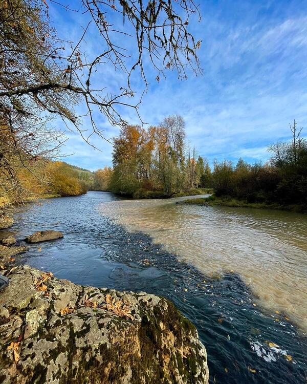
Sediment in rivers affects drinking water, flooding, ecosystem health, and community safety. The U.S. Environmental Protection Agency identifies sediment as one of the main reasons nearly half of rivers and streams in the United States are in fair or poor condition.
Too much sediment can:
- Fill river channels and increase flood risk
- Reduce reservoir storage capacity
- Carry pollutants such as metals, nutrients, and industrial chemicals
- Make the treatment of drinking water and generation of hydropower more difficult
- Harm fish, insects, and habitat in rivers
Understanding where sediment problems are most likely, and who is most affected, helps agencies and communities focus their monitoring and restoration efforts where they are needed most.
What This Study Provides
A U.S. Geological Survey research team developed a national sediment vulnerability ranking for 163 river basins across the contiguous United States. The rankings combine physical watershed characteristics with socioeconomic and ecological conditions to identify where excess sediment could most affect rivers and the social and ecological communities that depend on them.
These rankings can help:
- Prioritize monitoring
- Identify communities that are more at risk
- Guide water‑quality studies
- Support resource planning and management
How We Assessed Vulnerability
The balance between water and sediment and how it impacts ecosystems and communities can be very different across the landscape. The characteristics and amount of sediment in rivers depend on many physical factors of the landscape and watershed through which water flows. Some of the most influential factors include characteristics of the rock and soil, topography, climate and rainfall, land cover, land use, and disturbances like wildfire and floods. The vulnerability of ecosystems and communities to sediment depends in part on whether ecosystems are already stressed, and how communities rely on local rivers for drinking water, agriculture, recreation, or economic stability.
To account for these differences when assessing the vulnerability of social-ecological communities, the study examined six categories:
- Geomorphic setting: The physical landscape and soils that influence how sediment forms and moves.
- Modeled sediment and phosphorus: Computer models that estimate where sediment and nutrients are most likely to reach rivers.
- Hydrologic conditions: How water flows through a basin, including floods, low flows, and seasonal patterns.
- Land use and land cover: How people use the land—such as farming, development, or forest harvest—and how those uses affect erosion.
- Socioeconomic considerations: Community characteristics such as income, water supply sources, and access to resources that influence their ability to respond to excess sediment issues.
- Ecosystem sensitivity: Whether local rivers and riverine habitats are healthy or already stressed, and how susceptible they are to additional sediment.
Physical factors that regulate sediment availability included 1), 2), 3), and 4) from above. Social-ecological factors included 4) and 5) from above. The research team used statistical methods to select metrics that allow for ranking of sediment vulnerability between basins.
Key Findings
The research produced rankings and maps that show:
- Estimates of where excess sediment is most likely to occur
- Assessment of areas more likely to be impacted by excess sediment.
- A vulnerability ranking that combines the estimates of where excess sediment may occur with the potential impact of the sediment to social and ecological communities.
Sediment Vulnerability Hotspots
Sediment vulnerability is highest where there it a lot of sediment available and/or social‑ecological sensitivity is high. The Midwest; Souris–Red–Rainy; Tennessee–Missouri; Texas; Northern, Central, Southern High Plains regions ranked the highest for overall sediment vulnerability. Conversely, the Interior Mountain West regions ranked the lowest.

Regional Vulnerability Ranks
Regional ranks of sediment vulnerability in 18 regions across the contiguous U.S. can be used to prioritize specific watersheds or basins for monitoring and research within different parts of the U.S.

Physical and Social Factors Both Matter
Some basins are vulnerable because they produce a lot of sediment. Others are vulnerable because communities and ecosystems are more sensitive to sediment impacts.
Combining the physical and social-ecological perspectives provides a more complete understanding of vulnerability or risk—highlighting places that might be overlooked if only one factor is considered.

Data Gaps and Monitoring Needs
Many vulnerable basins lack sufficient sediment monitoring. These rankings can be used to help identify where resources and attention are most needed.
A national look at where excess sediment poses the greatest risks to communities and ecosystems.
Sediment in rivers affects drinking water, flooding, ecosystem health, and community safety. To better understand where excess sediment may create problems, the U.S. Geological Survey developed a national sediment vulnerability ranking for river basins across the contiguous United States. These rankings help identify where sediment poses the greatest risks—and where monitoring and research could make a difference.
Why Sediment Matters
Sediment in rivers affects drinking water, flooding, ecosystem health, and community safety. The U.S. Environmental Protection Agency identifies sediment as one of the main reasons nearly half of rivers and streams in the United States are in fair or poor condition.
Too much sediment can:
- Fill river channels and increase flood risk
- Reduce reservoir storage capacity
- Carry pollutants such as metals, nutrients, and industrial chemicals
- Make the treatment of drinking water and generation of hydropower more difficult
- Harm fish, insects, and habitat in rivers
Understanding where sediment problems are most likely, and who is most affected, helps agencies and communities focus their monitoring and restoration efforts where they are needed most.
What This Study Provides
A U.S. Geological Survey research team developed a national sediment vulnerability ranking for 163 river basins across the contiguous United States. The rankings combine physical watershed characteristics with socioeconomic and ecological conditions to identify where excess sediment could most affect rivers and the social and ecological communities that depend on them.
These rankings can help:
- Prioritize monitoring
- Identify communities that are more at risk
- Guide water‑quality studies
- Support resource planning and management
How We Assessed Vulnerability
The balance between water and sediment and how it impacts ecosystems and communities can be very different across the landscape. The characteristics and amount of sediment in rivers depend on many physical factors of the landscape and watershed through which water flows. Some of the most influential factors include characteristics of the rock and soil, topography, climate and rainfall, land cover, land use, and disturbances like wildfire and floods. The vulnerability of ecosystems and communities to sediment depends in part on whether ecosystems are already stressed, and how communities rely on local rivers for drinking water, agriculture, recreation, or economic stability.
To account for these differences when assessing the vulnerability of social-ecological communities, the study examined six categories:
- Geomorphic setting: The physical landscape and soils that influence how sediment forms and moves.
- Modeled sediment and phosphorus: Computer models that estimate where sediment and nutrients are most likely to reach rivers.
- Hydrologic conditions: How water flows through a basin, including floods, low flows, and seasonal patterns.
- Land use and land cover: How people use the land—such as farming, development, or forest harvest—and how those uses affect erosion.
- Socioeconomic considerations: Community characteristics such as income, water supply sources, and access to resources that influence their ability to respond to excess sediment issues.
- Ecosystem sensitivity: Whether local rivers and riverine habitats are healthy or already stressed, and how susceptible they are to additional sediment.
Physical factors that regulate sediment availability included 1), 2), 3), and 4) from above. Social-ecological factors included 4) and 5) from above. The research team used statistical methods to select metrics that allow for ranking of sediment vulnerability between basins.
Key Findings
The research produced rankings and maps that show:
- Estimates of where excess sediment is most likely to occur
- Assessment of areas more likely to be impacted by excess sediment.
- A vulnerability ranking that combines the estimates of where excess sediment may occur with the potential impact of the sediment to social and ecological communities.
Sediment Vulnerability Hotspots
Sediment vulnerability is highest where there it a lot of sediment available and/or social‑ecological sensitivity is high. The Midwest; Souris–Red–Rainy; Tennessee–Missouri; Texas; Northern, Central, Southern High Plains regions ranked the highest for overall sediment vulnerability. Conversely, the Interior Mountain West regions ranked the lowest.
Regional Vulnerability Ranks
Regional ranks of sediment vulnerability in 18 regions across the contiguous U.S. can be used to prioritize specific watersheds or basins for monitoring and research within different parts of the U.S.
Physical and Social Factors Both Matter
Some basins are vulnerable because they produce a lot of sediment. Others are vulnerable because communities and ecosystems are more sensitive to sediment impacts.
Combining the physical and social-ecological perspectives provides a more complete understanding of vulnerability or risk—highlighting places that might be overlooked if only one factor is considered.
Data Gaps and Monitoring Needs
Many vulnerable basins lack sufficient sediment monitoring. These rankings can be used to help identify where resources and attention are most needed.