



Exploring the Potential of Hyperspectral Data to Assess Phytoplankton Community Composition and Carbon Dynamics in Wetland-Estuarine Systems
USGS researchers will work with partners to utilize the hyperspectral information from the National Atmospheric and Science Administration (NASA) Earth Surface Mineral Dust Source Investigation (EMIT) instrument to estimate phytoplankton biomass and community composition in aquatic ecosystems.
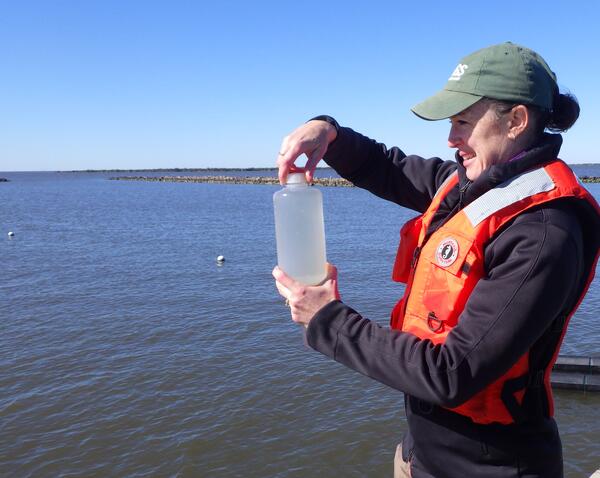
The Science Issue and Relevance: Wetland and estuarine systems play a critical role in connecting terrestrial landscapes with marine ecosystems.
Estuaries, often fringed with tidal wetlands, encompass river mouths, lagoons, and bays, forming unique ecosystems where the mix of freshwater and marine waters results in complex bio-optical characteristics (i.e., the absorption, scattering, and attenuation characteristics of the water influenced by the materials in the water column). These dynamic environments also host an array of habitats, in which the interplay of salinity gradient and nutrient availability play a crucial role in shaping the composition of phytoplankton assemblages, influencing biodiversity and ecological functioning. As a primary producer and source of food supply in aquatic ecosystems, phytoplankton are critical in aquatic ecosystems. The stability of the ecosystem structure and function depends strongly on the diversity of phytoplankton species.
Methodology for Addressing the Issue: The hyperspectral observations by the National Atmospheric and Science Administration (NASA) Earth Surface Mineral Dust Source Investigation (EMIT) instrument offers an untapped potential for monitoring water quality and biodiversity across diverse habitats, from estuarine open water and wetlands to coastal pelagic waters along Gulf of America.
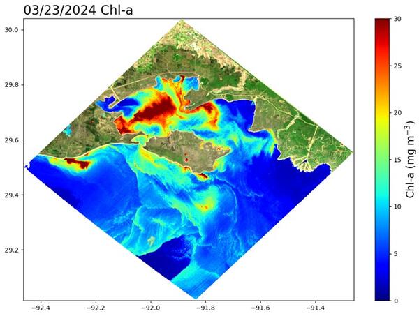
USGS researchers will work with NASA and university partners to test an advanced machine learning algorithm (mixture density networks) and refine a prior adaptive semi-analytical algorithm. This methodology will fully utilize the hyperspectral information from EMIT Level 2 surface reflectance data to infer the inherent optical properties (including phytoplankton absorption coefficients) to estimate phytoplankton biomass (chlorophyll a) and community composition, as well as dissolved and particulate organic carbon.
Future Steps: The resulting EMIT products will offer remote sensing capabilities to individual users, providing on-demand imagery tailored to research and management needs. Remote sensing imagery can also serve as crucial input for coastal water quality forecasting systems and may offer broader applicability to similar regions.
USGS researchers will work with partners to utilize the hyperspectral information from the National Atmospheric and Science Administration (NASA) Earth Surface Mineral Dust Source Investigation (EMIT) instrument to estimate phytoplankton biomass and community composition in aquatic ecosystems.
The Science Issue and Relevance: Wetland and estuarine systems play a critical role in connecting terrestrial landscapes with marine ecosystems.
Estuaries, often fringed with tidal wetlands, encompass river mouths, lagoons, and bays, forming unique ecosystems where the mix of freshwater and marine waters results in complex bio-optical characteristics (i.e., the absorption, scattering, and attenuation characteristics of the water influenced by the materials in the water column). These dynamic environments also host an array of habitats, in which the interplay of salinity gradient and nutrient availability play a crucial role in shaping the composition of phytoplankton assemblages, influencing biodiversity and ecological functioning. As a primary producer and source of food supply in aquatic ecosystems, phytoplankton are critical in aquatic ecosystems. The stability of the ecosystem structure and function depends strongly on the diversity of phytoplankton species.
Methodology for Addressing the Issue: The hyperspectral observations by the National Atmospheric and Science Administration (NASA) Earth Surface Mineral Dust Source Investigation (EMIT) instrument offers an untapped potential for monitoring water quality and biodiversity across diverse habitats, from estuarine open water and wetlands to coastal pelagic waters along Gulf of America.
USGS researchers will work with NASA and university partners to test an advanced machine learning algorithm (mixture density networks) and refine a prior adaptive semi-analytical algorithm. This methodology will fully utilize the hyperspectral information from EMIT Level 2 surface reflectance data to infer the inherent optical properties (including phytoplankton absorption coefficients) to estimate phytoplankton biomass (chlorophyll a) and community composition, as well as dissolved and particulate organic carbon.
Future Steps: The resulting EMIT products will offer remote sensing capabilities to individual users, providing on-demand imagery tailored to research and management needs. Remote sensing imagery can also serve as crucial input for coastal water quality forecasting systems and may offer broader applicability to similar regions.