
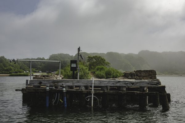
Continuous water quality gaging station located at Farm River at Farm River Marina near East Haven, Connecticut (USGS site ID 411513072512301). The station is placed on the floating dock.
Embayment Monitoring to Support Nutrient Management Activities in Connecticut for Long Island Sound
Active
By New England Water Science Center
September 27, 2021
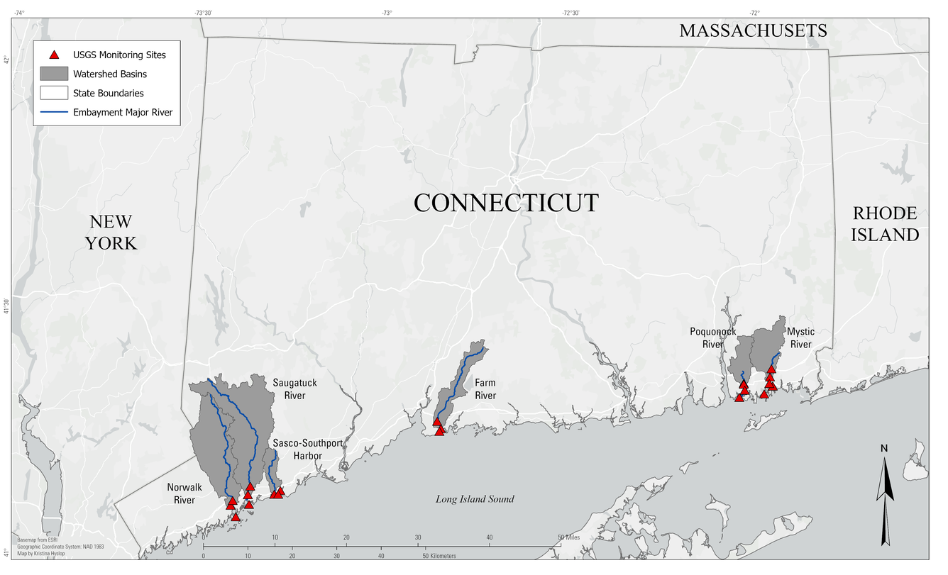
The USGS, in cooperation with the Connecticut Department of Energy and Environmental Protection will be collecting water-quality and hydrologic data at six embayments from April 2021 to June 2027: Mystic, Norwalk, Saugatuck, Sasco-Southport complex, Farm, and Poquonnock.
Media

Sources/Usage: Public Domain. View Media Details
Continuous water quality station on the Mystic River at the Mystic Seaport, Mystic Connecticut (Site ID 412141071580200). Setup includes top and bottom multiparameter sondes and velocity uplooker.
Coastal estuaries in southern New England show the effects of excess nutrients and coastal eutrophication. The effects of excess nutrients include excessive growth of macroalgae, excessive blooms of phytoplankton, hypoxia and oxygen depletion, and deteriorated substrates. Excessive nutrients also contribute to the loss of eelgrass, which provides important underwater habitat and was once commonly found in every bay and harbor in Long Island Sound (Vaudrey and others, 2013; Buzzards Bay National Estuary Program, undated). The state of Connecticut continues to promote a comprehensive approach to managing impacts to Long Island Sound and its coastal embayments and as part of that effort, the Connecticut Department of Energy and Environmental Protection (CT DEEP) seeks to develops monitoring and modeling efforts for selected embayment in LIS.
In 2021, The U.S. Geological Survey (USGS) in collaboration with CT DEEP began collecting water-quality and hydrologic information for two years in each embayment that could be used to inform embayment modeling efforts. Data collection in Norwalk Harbor and Mystic Harbor began in May 2021 and ended in April 2023, and Saugatuck River and Southport Harbor monitoring began in May 2022 and ended in April 2024. The Farm River monitoring began in April 2023 and ended in March 2025. The Poquonnock will be the sixth embayment to be monitored by the USGS in a concerted effort to provide hydrologic- and water-quality data available for CT DEEP’s embayment modeling efforts. The Poquonnock embayment began in July 2025 and will end in June 2027.
The objectives of the study are to 1) Obtain representative water‐quality data under a range of seasonal conditions to characterize the water-quality spatially and vertically within each embayment. 2) Collect selected water‐quality data with high temporal resolution to provide time‐series data needed for water-quality model calibration and evaluation. 3) Collect water-elevation and velocity data in each embayment to provide additional understanding of physical mixing and variability in the embayment. Nutrient models for each embayment will be created based on the collected data which will help improve the understanding of physical and chemical processes of embayments in Long Island Sound.
Media
Sources/Usage: Public Domain. View Media Details
Embayment monitoring sites in Connecticut for Long Island Sound.
Media
Sources/Usage: Public Domain. View Media Details
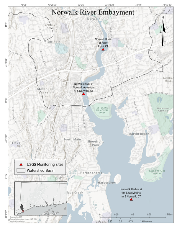
Locations of Norwalk embayment monitoring sites in Connecticut.
Media
Sources/Usage: Public Domain. View Media Details
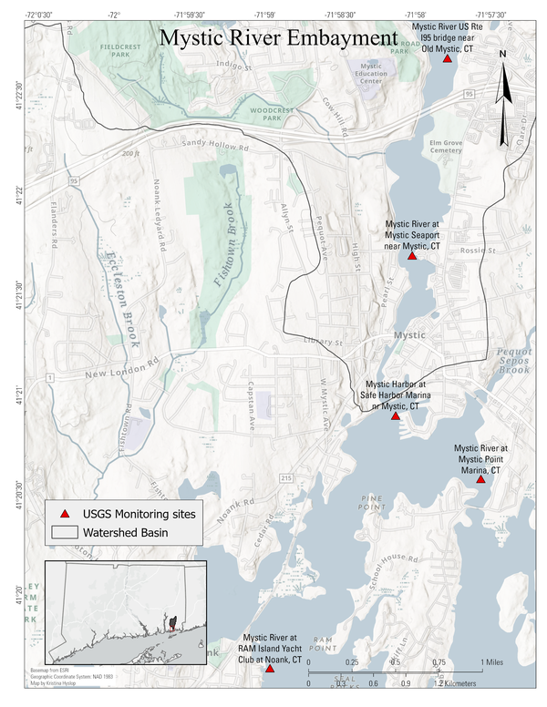
Locations of Mystic embayment monitoring sites in Connecticut
Media
Sources/Usage: Public Domain. View Media Details
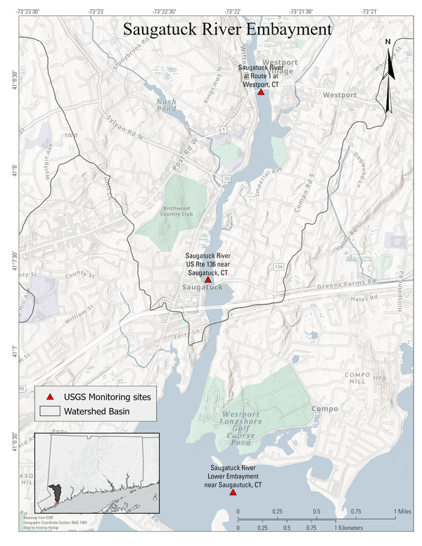
Locations of Saugatuck embayment monitoring sites in Connecticut.
Media
Sources/Usage: Public Domain. View Media Details
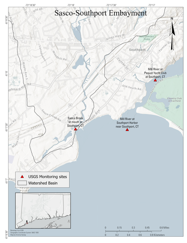
Locations of Sasco-Southport embayment monitoring sites in Connecticut.
Media
Sources/Usage: Public Domain. View Media Details
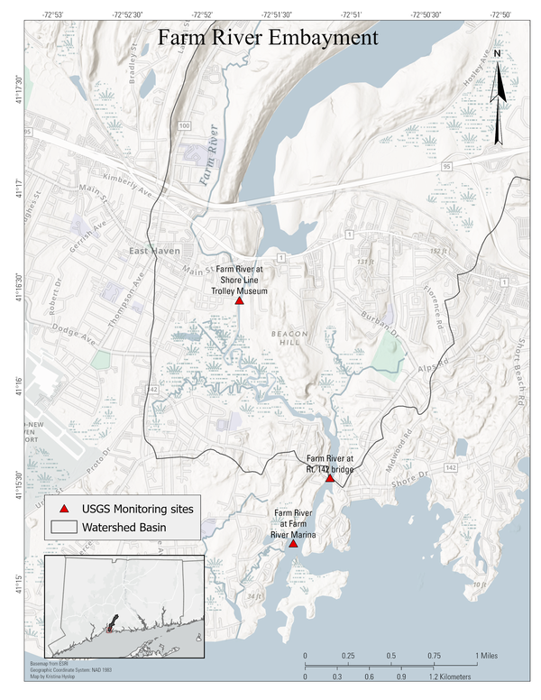
Locations of Farm embayment monitoring sites in Connecticut.
Media
Sources/Usage: Public Domain. View Media Details
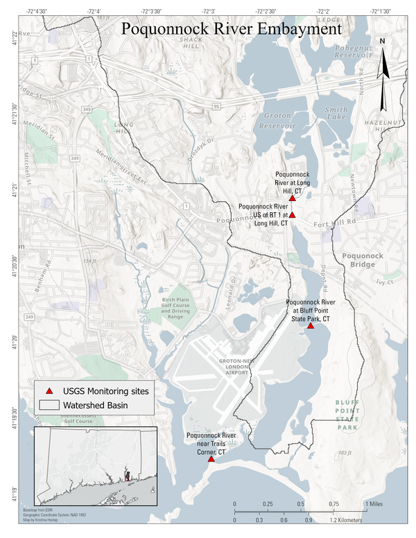
Locations of Poquonnock embayment monitoring sites in Connecticut.
Data collection sites
Site Number | Site Name | Timeline |
| 411940071590300 | Mystic River at Ram Island Yacht Club at Noank, CT | May 2021 - current* |
| 412141071580200 | Mystic River at Mystic Seaport near Mystic, CT | May 2021 - April 2023 |
| 412240071574700 | Mystic River US Rt I95 bridge near Old Mystic, CT | May 2021 - April 2023 |
| 412047071580800 | Mystic Harbor at Safe Harbor Marina near Mystic, CT | May 2021 - April 2023 |
| 412117071580800 | Mystic River at Rt. 1 bridge, CT | May 2021 - April 2023 |
| 412038071574900 | Mystic River at Mystic Point Marina, CT | May 2021 - April 2023 |
| 410502073236000 | Norwalk Harbor at the Cove Marina near E Norwalk, CT | May 2021 - current* |
| 410606073245700 | Norwalk River at Norwalk Aquarium near S Norwalk, CT | May 2021 - current* |
| 410643073243700 | Norwalk River at Ferry Point, CT | May 2021 - April 2023 |
| 410729073171701 | Mill River at Southport Harbor near Southport, CT (Buoy) | May 2022 - April 2024 |
| 410757073165601 | Mill River at Pequot Yacht Club at Southport, CT | May 2022 - April 2024 |
Sasco Brook at mouth at Southport, CT | May 2022 - April 2024 | |
| 410613073215801 | Saugatuck River Lower Embayment near Saugatuck, CT (Buoy) | May 2022 - April 2024 |
| 410724073221001 | Saugatuck River US Route 136 near Saugatuck, CT | May 2022 - current* |
| 01209510 | Saugatuck River at Route 1 at Westport, CT | May 2022 - current* |
| 01195399 | Farm River at Totoket Road at Totoket, CT | February 2020* - current* |
| 411513072512301 | Farm River at Farm River Marina NR East Haven, CT | April 2023 - March 2025 |
| 411532072510801 | Farm River at Route 142 Bridge Near East Haven, CT | April 2023 - March 2025 |
| 411626072514501 | Farm River at the Trolly Museum at East Haven, CT | April 2023 - March 2025 |
| 01119001 | Poquonnock River at Long Hill, CT | July 2025 - June 2027 |
| 412050072021701 | Poquonnock River US Rt 1 at Long Hill, CT | July 2025 - June 2027 |
| 412006072020801 | Poquonnock River at Bluff Point State Park, CT | July 2025 - June 2027 |
| 411914072030001 | Poquonnock River near Trails Corner, CT | July 2025 - June 2027 |
*Previous or ongoing data collection efforts for water quality and/or hydrologic data to support other USGS projects
Download Discrete Sample Data
Download Discrete Sample Data
National Water Dashboard
National Water Dashboard
Media

Continuous water quality gaging station located at Norwalk River at Norwalk Aquarium near South Norwalk, Connecticut (USGS site ID 410606073245700).
Sources/Usage: Public Domain. View Media Details
Media

Installation of continuous water quality gaging station at Mystic River at RAM Island Yacht Club at Noank, Connecticut (USGS site ID 411940071590300).
Sources/Usage: Public Domain. View Media Details
Media

USGS deployed this buoy platform with connected water quality equipment in Saugatuck Harbor, CT in May 2022.
Sources/Usage: Public Domain. View Media Details
Media

Continuous water quality gaging station located at Norwalk Harbor at the Cove Marina near East Norwalk, Connecticut (USGS site ID 410502073236000)
Sources/Usage: Public Domain. View Media Details
Media

Continuous water quality gaging station located at Farm River at Trolley Museum at East Haven, Connecticut (USGS site ID 411626072514501).
Sources/Usage: Public Domain. View Media Details
Media
Sources/Usage: Public Domain. View Media Details
Continuous water quality gaging station located at Poquonnock River at Bluff Point State Park, CT, Connecticut (USGS site ID 412006072020801)

Continuous water quality station
Continuous water quality gaging station located at Farm River at Farm River Marina near East Haven, Connecticut (USGS site ID 411513072512301). The station is placed on the floating dock.

Continuous water quality gaging station
Continuous water quality gaging station located at Farm River at Trolley Museum at East Haven, Connecticut (USGS site ID 411626072514501).
Continuous water quality gaging station located at Farm River at Trolley Museum at East Haven, Connecticut (USGS site ID 411626072514501).

USGS crew deploying Southport Buoy
USGS crew deployed this buoy platform with connected water quality equipment in Southport Harbor, CT in May 2022.
USGS crew deployed this buoy platform with connected water quality equipment in Southport Harbor, CT in May 2022.

USGS crew servicing water-quality monitors
USGS crew servicing water-quality monitors at Saugatuck Rowing Club, Connecticut.
USGS crew servicing water-quality monitors at Saugatuck Rowing Club, Connecticut.

USGS buoy platform with water quality equipment
USGS deployed this buoy platform with connected water quality equipment in Saugatuck Harbor, CT in May 2022.
USGS deployed this buoy platform with connected water quality equipment in Saugatuck Harbor, CT in May 2022.

Hydrologic technician servicing continuous water quality monitor
Hydrologic technician servicing continuous water quality monitorHydrologic technician servicing continuous water quality monitor at Mystic River US Route I-95 Bridge near Old Mystic, Connecticut, (USGS site ID 412240071574700)
Hydrologic technician servicing continuous water quality monitor
Hydrologic technician servicing continuous water quality monitorHydrologic technician servicing continuous water quality monitor at Mystic River US Route I-95 Bridge near Old Mystic, Connecticut, (USGS site ID 412240071574700)

Servicing continuous water quality monitor
Hydrologic technician servicing continuous water quality monitor at Mystic Harbor at Safe Harbor Marina near Mystic, Connecticut (USGS site ID 412240071580800)
Hydrologic technician servicing continuous water quality monitor at Mystic Harbor at Safe Harbor Marina near Mystic, Connecticut (USGS site ID 412240071580800)

Continuous water quality station
Continuous water quality station on the Mystic River at the Mystic Seaport, Mystic Connecticut (Site ID 412141071580200). Setup includes top and bottom multiparameter sondes and velocity uplooker.
Continuous water quality station on the Mystic River at the Mystic Seaport, Mystic Connecticut (Site ID 412141071580200). Setup includes top and bottom multiparameter sondes and velocity uplooker.

Collecting discrete water quality samples
Hydrologic technicians collecting discrete water quality samples at Norwalk River at Ferry Point near Norwalk, Connecticut (USGS Site ID 410643073243700)
Hydrologic technicians collecting discrete water quality samples at Norwalk River at Ferry Point near Norwalk, Connecticut (USGS Site ID 410643073243700)

Continuous water quality gaging station at Norwalk Harbor, Connecticut
Continuous water quality gaging station at Norwalk Harbor, ConnecticutContinuous water quality gaging station located at Norwalk Harbor at the Cove Marina near East Norwalk, Connecticut (USGS site ID 410502073236000)
Continuous water quality gaging station at Norwalk Harbor, Connecticut
Continuous water quality gaging station at Norwalk Harbor, ConnecticutContinuous water quality gaging station located at Norwalk Harbor at the Cove Marina near East Norwalk, Connecticut (USGS site ID 410502073236000)

Continuous water quality gaging station
Continuous water quality gaging station located at Norwalk River at Norwalk Aquarium near South Norwalk, Connecticut (USGS site ID 410606073245700)
Continuous water quality gaging station located at Norwalk River at Norwalk Aquarium near South Norwalk, Connecticut (USGS site ID 410606073245700)

Installation of continuous water quality station
Installation of continuous water quality gaging station at Mystic River at RAM Island Yacht Club at Noank, Connecticut (USGS site ID 411940071590300)
Installation of continuous water quality gaging station at Mystic River at RAM Island Yacht Club at Noank, Connecticut (USGS site ID 411940071590300)

Continuous stage only gaging station
Continuous stage only gaging station located at Mystic River at Rt. 1 bridge, Connecticut (USGS Site ID 412117071580800)
Continuous stage only gaging station located at Mystic River at Rt. 1 bridge, Connecticut (USGS Site ID 412117071580800)
The USGS, in cooperation with the Connecticut Department of Energy and Environmental Protection will be collecting water-quality and hydrologic data at six embayments from April 2021 to June 2027: Mystic, Norwalk, Saugatuck, Sasco-Southport complex, Farm, and Poquonnock.
Media
Sources/Usage: Public Domain. View Media Details
Continuous water quality station on the Mystic River at the Mystic Seaport, Mystic Connecticut (Site ID 412141071580200). Setup includes top and bottom multiparameter sondes and velocity uplooker.
Coastal estuaries in southern New England show the effects of excess nutrients and coastal eutrophication. The effects of excess nutrients include excessive growth of macroalgae, excessive blooms of phytoplankton, hypoxia and oxygen depletion, and deteriorated substrates. Excessive nutrients also contribute to the loss of eelgrass, which provides important underwater habitat and was once commonly found in every bay and harbor in Long Island Sound (Vaudrey and others, 2013; Buzzards Bay National Estuary Program, undated). The state of Connecticut continues to promote a comprehensive approach to managing impacts to Long Island Sound and its coastal embayments and as part of that effort, the Connecticut Department of Energy and Environmental Protection (CT DEEP) seeks to develops monitoring and modeling efforts for selected embayment in LIS.
In 2021, The U.S. Geological Survey (USGS) in collaboration with CT DEEP began collecting water-quality and hydrologic information for two years in each embayment that could be used to inform embayment modeling efforts. Data collection in Norwalk Harbor and Mystic Harbor began in May 2021 and ended in April 2023, and Saugatuck River and Southport Harbor monitoring began in May 2022 and ended in April 2024. The Farm River monitoring began in April 2023 and ended in March 2025. The Poquonnock will be the sixth embayment to be monitored by the USGS in a concerted effort to provide hydrologic- and water-quality data available for CT DEEP’s embayment modeling efforts. The Poquonnock embayment began in July 2025 and will end in June 2027.
The objectives of the study are to 1) Obtain representative water‐quality data under a range of seasonal conditions to characterize the water-quality spatially and vertically within each embayment. 2) Collect selected water‐quality data with high temporal resolution to provide time‐series data needed for water-quality model calibration and evaluation. 3) Collect water-elevation and velocity data in each embayment to provide additional understanding of physical mixing and variability in the embayment. Nutrient models for each embayment will be created based on the collected data which will help improve the understanding of physical and chemical processes of embayments in Long Island Sound.
Media
Sources/Usage: Public Domain. View Media Details
Embayment monitoring sites in Connecticut for Long Island Sound.
Media
Sources/Usage: Public Domain. View Media Details
Locations of Norwalk embayment monitoring sites in Connecticut.
Media
Sources/Usage: Public Domain. View Media Details
Locations of Mystic embayment monitoring sites in Connecticut
Media
Sources/Usage: Public Domain. View Media Details
Locations of Saugatuck embayment monitoring sites in Connecticut.
Media
Sources/Usage: Public Domain. View Media Details
Locations of Sasco-Southport embayment monitoring sites in Connecticut.
Media
Sources/Usage: Public Domain. View Media Details
Locations of Farm embayment monitoring sites in Connecticut.
Media
Sources/Usage: Public Domain. View Media Details
Locations of Poquonnock embayment monitoring sites in Connecticut.
Data collection sites
Site Number | Site Name | Timeline |
| 411940071590300 | Mystic River at Ram Island Yacht Club at Noank, CT | May 2021 - current* |
| 412141071580200 | Mystic River at Mystic Seaport near Mystic, CT | May 2021 - April 2023 |
| 412240071574700 | Mystic River US Rt I95 bridge near Old Mystic, CT | May 2021 - April 2023 |
| 412047071580800 | Mystic Harbor at Safe Harbor Marina near Mystic, CT | May 2021 - April 2023 |
| 412117071580800 | Mystic River at Rt. 1 bridge, CT | May 2021 - April 2023 |
| 412038071574900 | Mystic River at Mystic Point Marina, CT | May 2021 - April 2023 |
| 410502073236000 | Norwalk Harbor at the Cove Marina near E Norwalk, CT | May 2021 - current* |
| 410606073245700 | Norwalk River at Norwalk Aquarium near S Norwalk, CT | May 2021 - current* |
| 410643073243700 | Norwalk River at Ferry Point, CT | May 2021 - April 2023 |
| 410729073171701 | Mill River at Southport Harbor near Southport, CT (Buoy) | May 2022 - April 2024 |
| 410757073165601 | Mill River at Pequot Yacht Club at Southport, CT | May 2022 - April 2024 |
Sasco Brook at mouth at Southport, CT | May 2022 - April 2024 | |
| 410613073215801 | Saugatuck River Lower Embayment near Saugatuck, CT (Buoy) | May 2022 - April 2024 |
| 410724073221001 | Saugatuck River US Route 136 near Saugatuck, CT | May 2022 - current* |
| 01209510 | Saugatuck River at Route 1 at Westport, CT | May 2022 - current* |
| 01195399 | Farm River at Totoket Road at Totoket, CT | February 2020* - current* |
| 411513072512301 | Farm River at Farm River Marina NR East Haven, CT | April 2023 - March 2025 |
| 411532072510801 | Farm River at Route 142 Bridge Near East Haven, CT | April 2023 - March 2025 |
| 411626072514501 | Farm River at the Trolly Museum at East Haven, CT | April 2023 - March 2025 |
| 01119001 | Poquonnock River at Long Hill, CT | July 2025 - June 2027 |
| 412050072021701 | Poquonnock River US Rt 1 at Long Hill, CT | July 2025 - June 2027 |
| 412006072020801 | Poquonnock River at Bluff Point State Park, CT | July 2025 - June 2027 |
| 411914072030001 | Poquonnock River near Trails Corner, CT | July 2025 - June 2027 |
*Previous or ongoing data collection efforts for water quality and/or hydrologic data to support other USGS projects
Download Discrete Sample Data
Download Discrete Sample Data
National Water Dashboard
National Water Dashboard
Media
Continuous water quality gaging station located at Norwalk River at Norwalk Aquarium near South Norwalk, Connecticut (USGS site ID 410606073245700).
Sources/Usage: Public Domain. View Media Details
Media
Installation of continuous water quality gaging station at Mystic River at RAM Island Yacht Club at Noank, Connecticut (USGS site ID 411940071590300).
Sources/Usage: Public Domain. View Media Details
Media
USGS deployed this buoy platform with connected water quality equipment in Saugatuck Harbor, CT in May 2022.
Sources/Usage: Public Domain. View Media Details
Media
Continuous water quality gaging station located at Norwalk Harbor at the Cove Marina near East Norwalk, Connecticut (USGS site ID 410502073236000)
Sources/Usage: Public Domain. View Media Details
Media
Continuous water quality gaging station located at Farm River at Trolley Museum at East Haven, Connecticut (USGS site ID 411626072514501).
Sources/Usage: Public Domain. View Media Details
Media
Sources/Usage: Public Domain. View Media Details
Continuous water quality gaging station located at Poquonnock River at Bluff Point State Park, CT, Connecticut (USGS site ID 412006072020801)
Continuous water quality station
Continuous water quality gaging station located at Farm River at Farm River Marina near East Haven, Connecticut (USGS site ID 411513072512301). The station is placed on the floating dock.
Continuous water quality gaging station located at Farm River at Farm River Marina near East Haven, Connecticut (USGS site ID 411513072512301). The station is placed on the floating dock.
Continuous water quality gaging station
Continuous water quality gaging station located at Farm River at Trolley Museum at East Haven, Connecticut (USGS site ID 411626072514501).
Continuous water quality gaging station located at Farm River at Trolley Museum at East Haven, Connecticut (USGS site ID 411626072514501).
USGS crew deploying Southport Buoy
USGS crew deployed this buoy platform with connected water quality equipment in Southport Harbor, CT in May 2022.
USGS crew deployed this buoy platform with connected water quality equipment in Southport Harbor, CT in May 2022.
USGS crew servicing water-quality monitors
USGS crew servicing water-quality monitors at Saugatuck Rowing Club, Connecticut.
USGS crew servicing water-quality monitors at Saugatuck Rowing Club, Connecticut.
USGS buoy platform with water quality equipment
USGS deployed this buoy platform with connected water quality equipment in Saugatuck Harbor, CT in May 2022.
USGS deployed this buoy platform with connected water quality equipment in Saugatuck Harbor, CT in May 2022.
Hydrologic technician servicing continuous water quality monitor
Hydrologic technician servicing continuous water quality monitorHydrologic technician servicing continuous water quality monitor at Mystic River US Route I-95 Bridge near Old Mystic, Connecticut, (USGS site ID 412240071574700)
Hydrologic technician servicing continuous water quality monitor
Hydrologic technician servicing continuous water quality monitorHydrologic technician servicing continuous water quality monitor at Mystic River US Route I-95 Bridge near Old Mystic, Connecticut, (USGS site ID 412240071574700)
Servicing continuous water quality monitor
Hydrologic technician servicing continuous water quality monitor at Mystic Harbor at Safe Harbor Marina near Mystic, Connecticut (USGS site ID 412240071580800)
Hydrologic technician servicing continuous water quality monitor at Mystic Harbor at Safe Harbor Marina near Mystic, Connecticut (USGS site ID 412240071580800)
Continuous water quality station
Continuous water quality station on the Mystic River at the Mystic Seaport, Mystic Connecticut (Site ID 412141071580200). Setup includes top and bottom multiparameter sondes and velocity uplooker.
Continuous water quality station on the Mystic River at the Mystic Seaport, Mystic Connecticut (Site ID 412141071580200). Setup includes top and bottom multiparameter sondes and velocity uplooker.
Collecting discrete water quality samples
Hydrologic technicians collecting discrete water quality samples at Norwalk River at Ferry Point near Norwalk, Connecticut (USGS Site ID 410643073243700)
Hydrologic technicians collecting discrete water quality samples at Norwalk River at Ferry Point near Norwalk, Connecticut (USGS Site ID 410643073243700)
Continuous water quality gaging station at Norwalk Harbor, Connecticut
Continuous water quality gaging station at Norwalk Harbor, ConnecticutContinuous water quality gaging station located at Norwalk Harbor at the Cove Marina near East Norwalk, Connecticut (USGS site ID 410502073236000)
Continuous water quality gaging station at Norwalk Harbor, Connecticut
Continuous water quality gaging station at Norwalk Harbor, ConnecticutContinuous water quality gaging station located at Norwalk Harbor at the Cove Marina near East Norwalk, Connecticut (USGS site ID 410502073236000)
Continuous water quality gaging station
Continuous water quality gaging station located at Norwalk River at Norwalk Aquarium near South Norwalk, Connecticut (USGS site ID 410606073245700)
Continuous water quality gaging station located at Norwalk River at Norwalk Aquarium near South Norwalk, Connecticut (USGS site ID 410606073245700)
Installation of continuous water quality station
Installation of continuous water quality gaging station at Mystic River at RAM Island Yacht Club at Noank, Connecticut (USGS site ID 411940071590300)
Installation of continuous water quality gaging station at Mystic River at RAM Island Yacht Club at Noank, Connecticut (USGS site ID 411940071590300)
Continuous stage only gaging station
Continuous stage only gaging station located at Mystic River at Rt. 1 bridge, Connecticut (USGS Site ID 412117071580800)
Continuous stage only gaging station located at Mystic River at Rt. 1 bridge, Connecticut (USGS Site ID 412117071580800)